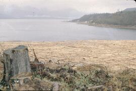
Williston Lake, BC

Elements area

Taxonomy

Code

Scope note(s)

    Source note(s)

      Display note(s)

        Hierarchical terms

        Williston Lake, BC

          Equivalent terms

          Williston Lake, BC

            Associated terms

            Williston Lake, BC

              15 Archival description results for Williston Lake, BC

              15 results directly related Exclude narrower terms
              2019.10.8 · File · 1 Aug. 1970
              Part of Lockwood Survey Corporation Ltd. collection

              These remote-sensing aerial photographs were taken by Lockwood Survey Corporation Ltd. under contract for the B.C. Forest Service. Some photographs are annotated to show logging activity; clearcuts, slash piles, log booms, and tree debris on the water are also visible in some of the images. No detailed location information or index accompanies the photographs. These historically important aerial photographs depict Williston Lake soon after its creation in 1968 with the building of the W.A.C. Bennett Dam on the Peace River. Also depicted are the rivers and tributaries that empty into the Williston Reservoir, such as the Finlay River, the Ospika River, and the Omineca River.

              The identification coding on these photographs can be interpreted as follows:

              • The largest number on the leftmost side is the frame number for the individual photograph.
              • The following code to the right in the format "B) 70-38" is currently unknown, but may refer to an internal project number for the Lockwood Survey Corporation.
              • The 6" may refer to the camera's focal length in inches.
              • Next is "17,150 ASL" which is 17,150 feet Above Sea Level.
              • Following is "152.63" which refers to the camera's focal length in millimeters, which equals 6 inches.
              • The "W1339" may refer to the reel, but that is unconfirmed.
              • "1 AUG 70" is the date the photos were taken.
              2019.10.9 · File · 1 Aug. 1970
              Part of Lockwood Survey Corporation Ltd. collection

              These remote-sensing aerial photographs were taken by Lockwood Survey Corporation Ltd. under contract for the B.C. Forest Service. Some photographs are annotated to show logging activity; clearcuts, slash piles, log booms, and tree debris on the water are also visible in some of the images. No detailed location information or index accompanies the photographs. These historically important aerial photographs depict Williston Lake soon after its creation in 1968 with the building of the W.A.C. Bennett Dam on the Peace River. Also depicted are the rivers and tributaries that empty into the Williston Reservoir, such as the Finlay River, the Ospika River, and the Omineca River.

              The identification coding on these photographs can be interpreted as follows:

              • The largest number on the leftmost side is the frame number for the individual photograph.
              • The following code to the right in the format "B) 70-38" is currently unknown, but may refer to an internal project number for the Lockwood Survey Corporation.
              • The 6" may refer to the camera's focal length in inches.
              • Next is "17,150 ASL" which is 17,150 feet Above Sea Level.
              • Following is "152.63" which refers to the camera's focal length in millimeters, which equals 6 inches.
              • The "W1339" may refer to the reel, but that is unconfirmed.
              • "1 AUG 70" is the date the photos were taken.
              2019.10.7 · File · 10 Sept. 1969
              Part of Lockwood Survey Corporation Ltd. collection

              These remote-sensing aerial photographs were taken by Lockwood Survey Corporation Ltd. under contract for the B.C. Forest Service. Some photographs are annotated to show logging activity; clearcuts, slash piles, log booms, and tree debris on the water are also visible in some of the images. No detailed location information or index accompanies the photographs. These historically important aerial photographs depict Williston Lake soon after its creation in 1968 with the building of the W.A.C. Bennett Dam on the Peace River. Also depicted are the rivers and tributaries that empty into the Williston Reservoir, such as the Finlay River, the Ospika River, and the Omineca River.

              The identification coding on these photographs can be interpreted as follows:

              • The largest number on the leftmost side is the frame number for the individual photograph.
              • The following code to the right in the format "B) 69-53" is currently unknown, but may refer to an internal project number for the Lockwood Survey Corporation.
              • The 6" may refer to the camera's focal length in inches.
              • Next is "17,150 ASL" which is 17,150 feet Above Sea Level.
              • Following is "152.52" which refers to the camera's focal length in millimeters, which equals 6 inches.
              • The "W1308" may refer to the reel, but that is unconfirmed.
              • "10 SEP 69" is the date the photos were taken.
              2019.10.1 · File · 3 July 1968
              Part of Lockwood Survey Corporation Ltd. collection

              These remote-sensing aerial photographs were taken by Lockwood Survey Corporation Ltd. under contract for the B.C. Forest Service. Some photographs are annotated to show logging activity; clearcuts, slash piles, log booms, and tree debris on the water are also visible in some of the images. No detailed location information or index accompanies the photographs. These historically important aerial photographs depict Williston Lake soon after its creation in 1968 with the building of the W.A.C. Bennett Dam on the Peace River. Also depicted are the rivers and tributaries that empty into the Williston Reservoir, such as the Finlay River, the Ospika River, and the Omineca River.

              The identification coding on these photographs can be interpreted as follows:

              • The largest number on the leftmost side is the frame number for the individual photograph.
              • The following code to the right in the format B) 67-326 is currently unknown, but may refer to an internal project number for the Lockwood Survey Corporation.
              • The 6" may refer to the camera's focal length in inches.
              • Next is "17,000 ASL" which is 17,000 feet Above Sea Level.
              • Following is "152.17" which refers to the camera's focal length in millimeters, which equals 6 inches.
              • The "W1245" may refer to the reel, but that is unconfirmed.
              • "3 JUL 68" is the date the photos were taken.
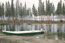
              2019.10.2 · File · 8 Sept. 1969
              Part of Lockwood Survey Corporation Ltd. collection

              These remote-sensing aerial photographs were taken by Lockwood Survey Corporation Ltd. under contract for the B.C. Forest Service. Some photographs are annotated to show logging activity; clearcuts, slash piles, log booms, and tree debris on the water are also visible in some of the images. No detailed location information or index accompanies the photographs. These historically important aerial photographs depict Williston Lake soon after its creation in 1968 with the building of the W.A.C. Bennett Dam on the Peace River. Also depicted are the rivers and tributaries that empty into the Williston Reservoir, such as the Finlay River, the Ospika River, and the Omineca River.

              The identification coding on these photographs can be interpreted as follows:

              • The largest number on the leftmost side is the frame number for the individual photograph.
              • The following code to the right in the format B) 69-53 is currently unknown, but may refer to an internal project number for the Lockwood Survey Corporation.
              • The 6" may refer to the camera's focal length in inches.
              • Next is "17,150 ASL" which is 17,150 feet Above Sea Level.
              • Following is "152.52" which refers to the camera's focal length in millimeters, which equals 6 inches.
              • The "W1307" may refer to the reel, but that is unconfirmed.
              • "8 SEP 69" is the date the photos were taken.
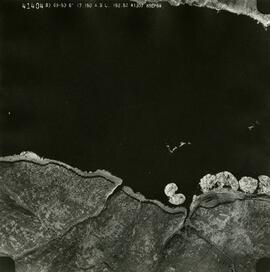
              2019.10.3 · File · 8 Sept. 1969
              Part of Lockwood Survey Corporation Ltd. collection

              These remote-sensing aerial photographs were taken by Lockwood Survey Corporation Ltd. under contract for the B.C. Forest Service. Some photographs are annotated to show logging activity; clearcuts, slash piles, log booms, and tree debris on the water are also visible in some of the images. No detailed location information or index accompanies the photographs. These historically important aerial photographs depict Williston Lake soon after its creation in 1968 with the building of the W.A.C. Bennett Dam on the Peace River. Also depicted are the rivers and tributaries that empty into the Williston Reservoir, such as the Finlay River, the Ospika River, and the Omineca River.

              The identification coding on these photographs can be interpreted as follows:

              • The largest number on the leftmost side is the frame number for the individual photograph.
              • The following code to the right in the format B) 69-53 is currently unknown, but may refer to an internal project number for the Lockwood Survey Corporation.
              • The 6" may refer to the camera's focal length in inches.
              • Next is "17,150 ASL" which is 17,150 feet Above Sea Level.
              • Following is "152.52" which refers to the camera's focal length in millimeters, which equals 6 inches.
              • The "W1307" may refer to the reel, but that is unconfirmed.
              • "8 SEP 69" is the date the photos were taken.
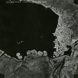
              2019.10.4 · File · 8 Sept. 1969
              Part of Lockwood Survey Corporation Ltd. collection

              These remote-sensing aerial photographs were taken by Lockwood Survey Corporation Ltd. under contract for the B.C. Forest Service. Some photographs are annotated to show logging activity; clearcuts, slash piles, log booms, and tree debris on the water are also visible in some of the images. No detailed location information or index accompanies the photographs. These historically important aerial photographs depict Williston Lake soon after its creation in 1968 with the building of the W.A.C. Bennett Dam on the Peace River. Also depicted are the rivers and tributaries that empty into the Williston Reservoir, such as the Finlay River, the Ospika River, and the Omineca River.

              The identification coding on these photographs can be interpreted as follows:

              • The largest number on the leftmost side is the frame number for the individual photograph.
              • The following code to the right in the format B) 69-53 is currently unknown, but may refer to an internal project number for the Lockwood Survey Corporation.
              • The 6" may refer to the camera's focal length in inches.
              • Next is "17,150 ASL" which is 17,150 feet Above Sea Level.
              • Following is "152.52" which refers to the camera's focal length in millimeters, which equals 6 inches.
              • The "W1307" may refer to the reel, but that is unconfirmed.
              • "8 SEP 69" is the date the photos were taken.
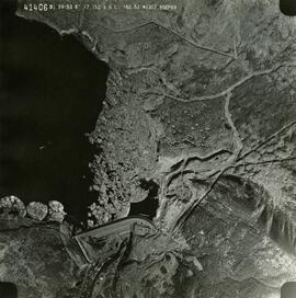
              2019.10.5 · File · 9 Sept. 1969
              Part of Lockwood Survey Corporation Ltd. collection

              These remote-sensing aerial photographs were taken by Lockwood Survey Corporation Ltd. under contract for the B.C. Forest Service. Some photographs are annotated to show logging activity; clearcuts, slash piles, log booms, and tree debris on the water are also visible in some of the images. No detailed location information or index accompanies the photographs. These historically important aerial photographs depict Williston Lake soon after its creation in 1968 with the building of the W.A.C. Bennett Dam on the Peace River. Also depicted are the rivers and tributaries that empty into the Williston Reservoir, such as the Finlay River, the Ospika River, and the Omineca River.

              The identification coding on these photographs can be interpreted as follows:

              • The largest number on the leftmost side is the frame number for the individual photograph.
              • The following code to the right in the format "B) 69-53" is currently unknown, but may refer to an internal project number for the Lockwood Survey Corporation.
              • The 6" may refer to the camera's focal length in inches.
              • Next is "17,150 ASL" which is 17,150 feet Above Sea Level.
              • Following is "152.52" which refers to the camera's focal length in millimeters, which equals 6 inches.
              • The "W1308" may refer to the reel, but that is unconfirmed.
              • "9 SEP 69" is the date the photos were taken.
              2019.10.6 · File · 9 Sept. 1969
              Part of Lockwood Survey Corporation Ltd. collection

              These remote-sensing aerial photographs were taken by Lockwood Survey Corporation Ltd. under contract for the B.C. Forest Service. Some photographs are annotated to show logging activity; clearcuts, slash piles, log booms, and tree debris on the water are also visible in some of the images. No detailed location information or index accompanies the photographs. These historically important aerial photographs depict Williston Lake soon after its creation in 1968 with the building of the W.A.C. Bennett Dam on the Peace River. Also depicted are the rivers and tributaries that empty into the Williston Reservoir, such as the Finlay River, the Ospika River, and the Omineca River.

              The identification coding on these photographs can be interpreted as follows:

              • The largest number on the leftmost side is the frame number for the individual photograph.
              • The following code to the right in the format "B) 69-53" is currently unknown, but may refer to an internal project number for the Lockwood Survey Corporation.
              • The 6" may refer to the camera's focal length in inches.
              • Next is "17,150 ASL" which is 17,150 feet Above Sea Level.
              • Following is "152.52" which refers to the camera's focal length in millimeters, which equals 6 inches.
              • The "W1308" may refer to the reel, but that is unconfirmed.
              • "9 SEP 69" is the date the photos were taken.
              2019.10 · Collection · 1968-1970

              These historically important aerial photographs depict Williston Lake soon after its creation in 1968 with the building of the W.A.C. Bennett Dam on the Peace River. Also depicted are the rivers and tributaries that empty into the Williston Reservoir, such as the Finlay River, the Ospika River, and the Omineca River.

              These remote-sensing aerial photographs were taken by Lockwood Survey Corporation Ltd. under contract for the B.C. Forest Service. Some photographs are annotated to show logging activity; clearcuts, slash piles, log booms, and tree debris on the water are also visible in some of the images. No detailed location information or index accompanies the photographs.

              Lockwood Survey Corporation Ltd.
              2019.10.4.41404 · Item · 8 Sept. 1969
              Part of Lockwood Survey Corporation Ltd. collection

              This remote-sensing aerial photograph was taken by Lockwood Survey Corporation Ltd. under contract for the B.C. Forest Service. This historically important aerial photograph depicts the headwaters of Williston Reservoir soon after its creation in 1968 with the building of the W.A.C. Bennett Dam on the Peace River.

              The identification coding on these photographs can be interpreted as follows:

              • The largest number on the leftmost side is the frame number for the photograph.
              • The following code to the right in the format B) 69-53 is currently unknown, but may refer to an internal project number for the Lockwood Survey Corporation.
              • The 6" may refer to the camera's focal length in inches.
              • Next is "17,150 ASL" which is 17,150 feet Above Sea Level.
              • Following is "152.52" which refers to the camera's focal length in millimeters, which equals 6 inches.
              • The "W1307" may refer to the reel, but that is unconfirmed.
              • "8 SEP 69" is the date the photo was taken.
              2019.10.4.41405 · Item · 8 Sept. 1969
              Part of Lockwood Survey Corporation Ltd. collection

              This remote-sensing aerial photograph was taken by Lockwood Survey Corporation Ltd. under contract for the B.C. Forest Service. This historically important aerial photograph depicts the W.A.C. Bennett Dam and Williston Reservoir soon after its flooding in 1968.

              The identification coding on these photographs can be interpreted as follows:

              • The largest number on the leftmost side is the frame number for the photograph.
              • The following code to the right in the format B) 69-53 is currently unknown, but may refer to an internal project number for the Lockwood Survey Corporation.
              • The 6" may refer to the camera's focal length in inches.
              • Next is "17,150 ASL" which is 17,150 feet Above Sea Level.
              • Following is "152.52" which refers to the camera's focal length in millimeters, which equals 6 inches.
              • The "W1307" may refer to the reel, but that is unconfirmed.
              • "8 SEP 69" is the date the photo was taken.
              2019.10.4.41406 · Item · 8 Sept. 1969
              Part of Lockwood Survey Corporation Ltd. collection

              This remote-sensing aerial photograph was taken by Lockwood Survey Corporation Ltd. under contract for the B.C. Forest Service. This historically important aerial photograph depicts the W.A.C. Bennett Dam and Williston Reservoir soon after its flooding in 1968.

              The identification coding on these photographs can be interpreted as follows:

              • The largest number on the leftmost side is the frame number for the photograph.
              • The following code to the right in the format B) 69-53 is currently unknown, but may refer to an internal project number for the Lockwood Survey Corporation.
              • The 6" may refer to the camera's focal length in inches.
              • Next is "17,150 ASL" which is 17,150 feet Above Sea Level.
              • Following is "152.52" which refers to the camera's focal length in millimeters, which equals 6 inches.
              • The "W1307" may refer to the reel, but that is unconfirmed.
              • "8 SEP 69" is the date the photo was taken.
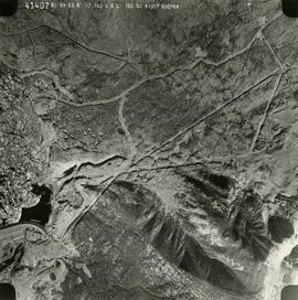
              2019.10.4.41407 · Item · 8 Sept. 1969
              Part of Lockwood Survey Corporation Ltd. collection

              This remote-sensing aerial photograph was taken by Lockwood Survey Corporation Ltd. under contract for the B.C. Forest Service. This historically important aerial photograph depicts the W.A.C. Bennett Dam and Williston Reservoir soon after its flooding in 1968.

              The identification coding on these photographs can be interpreted as follows:

              • The largest number on the leftmost side is the frame number for the photograph.
              • The following code to the right in the format B) 69-53 is currently unknown, but may refer to an internal project number for the Lockwood Survey Corporation.
              • The 6" may refer to the camera's focal length in inches.
              • Next is "17,150 ASL" which is 17,150 feet Above Sea Level.
              • Following is "152.52" which refers to the camera's focal length in millimeters, which equals 6 inches.
              • The "W1307" may refer to the reel, but that is unconfirmed.
              • "8 SEP 69" is the date the photo was taken.
              2016.5.5.01 · File · [19-?]
              Part of Harry Coates fonds

              File consists of trail maps and recreation guides from various places in British Columbia, especially Northern British Columbia. Maps include:

              • British Columbia Road Map and Parks Guide
              • Northwood Pulp and Timber Limited Forest Operations Recreation Map
              • Provincial Parks of Northern British Columbia
              • Visitor's Guide: Mackenzie Woodlands
              • Visitors Guide: Mackenzie Woodlands
              • Mackenzie Forest District Recreation Map
              • Dawson Creek Forest District Recreation Map
              • Morice Forest District Recreation Map
              • Fort St. James Forest District Recreation Map
              • Lakes Forest District Recreation Map
              • Cariboo Forest Region Recreation Map
              • Lakes District Visitors Map
              • Prince George Forest District Recreation Map
              • Vanderhoof Forest District Recreation Map
              • Fort St. John Forest District Recreation Map
              • Cariboo Forest Region Recreation Map (East)
              • Robson Valley Forest District Recreation Map
              • Fort Nelson Forest District Recreation Map
              • Forest Service Recreation Sites: Valemount - Blue River
              • Forest Service Recreation Sites: McBride - Goat River
              • Forest Service Recreation Sites: Prince George West
              • Forest Service Recreation Sites: Moberly - Sukunka
              • Forest Service Recreation Sites: Nation - Takla
              • Forest Service Recreation Sites: Murrat - Kiskatinaw
              • Recreation Road Map for the Prince George Forest Area (1987-1988)
              • Recreation Road Map for the Prince George Forest Area (1997)
              • The Bobtail Forest Service Road Tour
              • Forest Recreation Map: Northwood Pulp and Timber Limited
              • Forest Operations Recreation Map: Northwood pulp and timber limited
              • Forest Service: Recreation Sites Williston/Mackenzie
              • Forest Service Recreation Sites Prince George West
              • The Official Prince George Tourist Street Map
              • Ecological Reserves in British Columbia (July 1990)
              • Prince George Forest District map (April 1990) with annotations regarding trials.