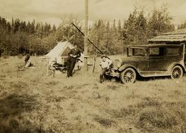
Photograph depicts (from left to right) Gordon Wyness and Jack Lee at a camp scene "at Bobtail" (possibly Bobtail Lake) near Vanderhoof. As noted in the album caption, the crew had "just returned from Vanderhoof". The telegraph cabin roof and their 1930 Buick Series 40 car is visible at right.
Vanderhoof, BC
9 Archival description results for Vanderhoof, BC
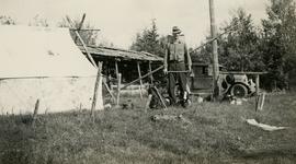
Photograph depicts Gordon Wyness at the Bobtail campsite after having just returned from a night of camping without a tent on Bobtail Mountain. Wyness noted (on photograph verso) that there were pack rats in the telegraph cabin in the background of this photograph.
Photograph depicts Gordon Wyness at the Bobtail campsite after having just returned from a night of camping without a tent on Bobtail Mountain. Wyness noted (on photograph verso) that there were pack rats in the telegraph cabin in the background of this photograph.
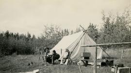
Photograph depicts Jack Lee with gear in front of a tent at Bobtail [Lake?] campsite after returning from Bobtail Mountain where the crew had camped overnight without a tent.
Photograph depicts Jack Lee with gear in front of a tent at Bobtail [Lake?] campsite after returning from Bobtail Mountain where the crew had camped overnight without a tent.
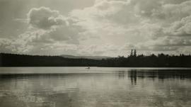
Photograph depicts Jack Lee rafting with a sail on Bobtail Lake, as he was going over to other side of the lake to locate traverse posts (without success, according to the annotation on the photograph verso).
File consists of records created and accumulated by Gary Runka over the course of his consultancy work for W.D. McIntosh Land Surveying Ltd. for the "Fawcett Farm Subdivision and Consolidation" project in Vanderhoof. This file was numbered as G.G. Runka Land Sense Ltd. client file #336; that client number may be seen referenced elsewhere in the G. Gary Runka fonds. The Land Sense Ltd. client files generally include records such as correspondence, contracts, invoices, project reports, publications, ephemera, memoranda, maps or map excerpts, legal documents, meeting materials, clippings, and handwritten notes.
Includes the following map:
- W.D. McIntosh B.C. Land Surveyor, "Plan of Proposed Subdivision of the SE 1/4, SW 1/4 of Section 33, and the N 1/2 of Section 32, all in Township 3, Range 4, Coast District", 1988.
File consists of records created and accumulated by Gary Runka over the course of his consultancy work for W.D. McIntosh Land Surveying Ltd. for the "Proposed Log Home Construction Use" project in Vanderhoof. This file was numbered as G.G. Runka Land Sense Ltd. client file #566; that client number may be seen referenced elsewhere in the G. Gary Runka fonds. The Land Sense Ltd. client files generally include records such as correspondence, contracts, invoices, project reports, publications, ephemera, memoranda, maps or map excerpts, legal documents, meeting materials, clippings, and handwritten notes.
File consists of records created and accumulated by Gary Runka over the course of his consultancy work for W.D. McIntosh Land Surveying Ltd. for the "Consultations on Proposed Log Home Building Operation Land Use" project in Vanderhoof. This file was numbered as G.G. Runka Land Sense Ltd. client file #597; that client number may be seen referenced elsewhere in the G. Gary Runka fonds. The Land Sense Ltd. client files generally include records such as correspondence, contracts, invoices, project reports, publications, ephemera, memoranda, maps or map excerpts, legal documents, meeting materials, clippings, and handwritten notes.


