Digital video recording is an episode of Spotlight on UNBC from October 1993. Features include an announcement that the Prince George campus will be opening on time and construction deadlines have been met, the cataloging process for the UNBC library, recruitment of faculty, housing developments, student retainment, hiring of academic faculty, preparations for the grand opening of the campus, the UNBC School of Nursing regional operations, the UNBC scholarship and bursary fund, the North to the Future campaign, Regional Coordinators and their importance, and the UNBC adrenaline club. Includes interviews with Geoffrey Weller (UNBC President), Ken Coates (VP Academic), Pat Appavoo (University Librarian), Dennis Macknak (Regional Operations and University College Relations), John Backhouse (Mayor of Prince George), Jan Thompson (President of the Cariboo Real Estate Board), Mary Louise McAllister (Political Science), Lee Keener (Math and Computer Science), Annie Booth (Environmental Studies), Karen Borsato (CNC Registration Manager, Quesnel campus), Mike Chiu (Telecommunications Supervisor), Tracey Niesh (Secretary for Regional Operations), Rob Corbett (Director of Human Resources), Joanne Fort (Northwest Community College), Leslie Hardy, Paul Ramsey (PG North MLA), Ellen Facey (South-Central Regional Coordinator), and Brian Cole (UNBC student).
Prince George, BC
2402 Archival description results for Prince George, BC
2402 results directly related
Exclude narrower terms
1994.1.1.5.1.08
·
Item
·
1993
Part of UNBC Office of External Relations
1994.1.1.5.1.20
·
Item
·
1994
Part of UNBC Office of External Relations
Digital video recording is an episode of Spotlight on UNBC from October 1994. Features include interviews with students and faculty regarding the opening of the UNBC campus (Sept. 8, 1994 was Opening Day); class registration for students; student orientation; ongoing construction on campus; a Land Use and Resource Management Symposium; a conference on post-nationalism in Canada presented by the UNBC English Department; an interview with Greg Poelzer regarding research in Russia on social and political issues with aboriginal peoples; a $50,000 donation to the North to the Future campaign from BC Rail; the unveiling of a mural by local artists representing the opening of UNBC; and a tour of student residence apartments by students. Includes interviews with Geoffrey Weller (UNBC President); Don Cyr (UNBC Business Administration); Mark Bernards (UNBC Chemistry); Murray Sadler (UNBC Founder); Tom Steadman (UNBC Founder); Iona Campagnolo (UNBC Chancellor); Paul Thomson (UNBC Registrar); Carol Sigurdson (UNBC Student Services Director); Fred Gilbert (Dean, Natural Resources and Environmental Studies); Karin Beeler (UNBC English); Greg Poelzer (UNBC Political Science); Paul Jiles (BC Rail Chairman); Ken Ferris (Artist); Randall Brazzoni (UNBC Housing Manager); and UNBC students Denise Watt, Christie Westman, and Kelly Pastro.
1994.1.1.5.1.29
·
Item
·
1995
Part of UNBC Office of External Relations
Digital video recording is an episode of Spotlight on UNBC from October 1995. Features segments on research into the fish kill at Tabor Lake; a Siberian First Nations visited the region to meet our First Nations; the transition to UNBC's new president Charles Jago and the interim president George Pedersen); a PowerSmart donation from BC Hydro to UNBC; UNBC recruitment in local high schools; UNBC library journal subscriptions and access to eResources; the "North to the Future" campaign"; and footage from the "North to the Future" promotional video. Includes interviews with Ellen Petticrew (UNBC Geography); Sean Simmons (UNBC student); Gail Fondahl (UNBC Geography); Nikolai Arvneev (Evenki); Chief Joseph Gosnell (Nisga'a Nation); Galina Abramova (Evenk Cultural Centre); George Pedersen (UNBC Interim President); Iona Campagnolo (UNBC Chancellor); Peter Bentley (Canadian Forest Products); Ken Coates (Founding VP Academic); Pat Appavoo (UNBC Librarian); Godfrey Medhurst (UNBC Facilities); Jennifer Hollands (UNBC Liaison Officer); Claudette Gouger (UNBC Liaison Officer); Mari-Etha Pienaar (Prince Rupert); Mayor John Kuz (Prince Rupert); Brent Campbell (Deloitte and Touche, Prince George); Geoffrey Weller (UNBC President); Tom Steadman (UNBC Founder); Paul Shelley (Royal Bank); Winnifred Kessler (UNBC Forestry); Tom Boughner (Skeena Cellulose); and C.T. Hazelwood (Northwood Pulp and Timber).
1994.1.1.5.1.39
·
Item
·
1996
Part of UNBC Office of External Relations
Digital video recording is an episode of Spotlight on UNBC from October 1996. Features segments on the 1996 Fall semester at UNBC with UNBC at near-full capacity; a course offered in Quesnel by the Child Welfare Research Centre; Iona Campagnolo's Chancellor's Tour in the regions; the "North to the Future" campaign; a new weather tower set up for research at the UNBC Prince George campus; UNBC staff and student artwork exhibition presented by the UNBC Arts Council; and a 5-day summer course on local history taught in Barkerville. Includes interviews with Charles Jago (UNBC President), Gordon Ternowetsky (UNBC Social Work), Iona Campagnolo (UNBC Chancellor), Nate Bello (Quesnel City Councillor), George Marlotte (Bank of Nova Scotia), Deborah Poff (UNBC VP Academic), Jon Swainger (UNBC History), Peter Jackson (UNBC Environmental Studies), Eve Pankovitch (UNBC Arts Council), Mary Ellen Kelm (UNBC History), and Robin Fisher (Dean).
1994.1.1.5.1.49
·
Item
·
1997
Part of UNBC Office of External Relations
Digital video recording is an episode of Spotlight on UNBC from October 1997. Features segments on UNBC student orientation; the Northern Advancement Program; a new doctoral program in Natural Resources Management; tourism development by Resource & Recreation program students; a memory test for Alzheimer's patients; a survey on MacGregor Model Forest; UNBC professor won the Volunteer of the Year Award from the Science Council of British Columbia; UNBC students participated in an archaeological dig in Russia; the Global Change Game; Shine-a-rama; Wheel Thang race on campus; and the UNBC Timberwolves men's and women's basketball teams. Includes interviews with Alex Reed (UNBC Assoc. VP); Edmond Constantineau (UNBC First Nations Studies); Max Blouw (UNBC VP Research); Robin Draper (BC Parks); Rob Altemeyer (Global Change Game); Jim Leonard (UNBC Counsellor); Chris Doucette (Wheel Thang); Loralyn Murdoch (Timberwolves coach); Dave Petryk (Tourism Prince George); Anita Hubley (UNBC Psychology); David Robinson (UNBC faculty); Alex Hawley (UNBC faculty); Deborah Poff (UNBC VP); Todd Whitcombe (UNBC Chemistry); and UNBC students Phyllis Joseph, Erin Sherry, Shelly Webber, Kati Eriksen, Dan Byzyna, Dawn Hemingway, Laura Ryser, Jo Burrows, Sarah Ramage, Zane Robinson, and Kari Slater.
1994.1.1.5.1.57
·
Item
·
1998
Part of UNBC Office of External Relations
Digital video recording is an episode of Spotlight on UNBC from October 1998. Features segments on the new bachelor's program in Northern Studies; the construction underway for the Irving K. Barber Enhanced Forestry Laboratory; the first ranking for UNBC the Maclean's ratings; Includes interviews with John Sam and Derrick Chief (artists of "Gathering of the Clans" mirror); Gary Miltonberger (Energy, Mines & Petroleum Resources); Orland Wilkerson (UNBC Environmental Studies); Carolee Clyne (UNBC Computing Services); Chief Ken Russell (Gitsegukla); Doug Baker (UNBC Environmental Studies); Brad Gagnon (Zoe's Earth Collections); Jane Young (UNBC Biology); Charles Jago (UNBC President); Robin Fisher (Dean of Arts, Social, and Health Sciences); Annette Browne (UNBC Nursing); Geraldine Thomas (Stoney Creek); Ken Prkachin (UNBC Psychology); Dave Ryan (Gitsegukla Hemp Corporation); Mary-Ellen Kelm (UNBC History); John Young (UNBC Political Science); Dale Lovick (Aboriginal Affairs Minister); Michael Bliss (historian); and UNBC students and alumni Oliver Ray, Bill Carpenter (UNBC Rugby Club), Jamie Kerr (UNBC Rugby Club), Susan Nykoluk, Anne Mariscak, Carla Payne, Jo Burrows (Anthropology), Sarah Ramage (Anthropology), Laurie Hildebrand, and Todd Rosie (English).
1994.1.1.5.1.62
·
Item
·
1999
Part of UNBC Office of External Relations
Digital video recording is an episode of Spotlight on UNBC from October 1999, which is mainly a montage episode of 1998 UNBC events. Features include donations to UNBC, research in Hazleton, a new degree program for Fort St. John for the oil and gas industry, a new bachelors program in Northern Studies, construction under way for the Irving K Barber Enhanced Forestry Laboratory, the first ranking for UNBC in Maclean's magazine, Gitksan Nation hemp project, a new student computer lab on campus, the "Gathering of the Clans" mirror art donation, Wheel Thang race with rollerblades and bikes, women's healthcare experiences with rural healthcare systems, Barkerville history course, UNBC political science students visit Russia, jazz and poetry nights, and the Delgamuukw Forum.
1994.1.1.5.1.67
·
Item
·
2000
Part of UNBC Office of External Relations
Digital video recording is an episode of Spotlight on UNBC from October 2000. Features segments on the new lab expansion, the possibility of a partnership with AXOR for a planned R&D park near the lab building at the Prince George campus, the Apple computer lab, the first UNBC archaeological field school at Hatsul Heritage Village at Soda Creek, increased international student exchange opportunities, the Northern New Media Conference, the Innovation Resource Centre, the Geoffrey R. Weller memorial and dedication of the Weller Library, and the 10th Anniversary of UNBC. Also includes a report on the Tumbler Ridge economic crisis due to the closure of the Quintette coal mine and the Bull Moose mine, which includes features on the Tumbler Ridge Housing Corporation sale and the Tumbler Ridge Diversification Society. Includes interviews with Max Blouw (UNBC Assoc. VP Research), Al Galbraith (Tumbler Ridge Housing Corporation), Claudette Gouger (UNBC Alumni Association), Graham Gobrick (Minister of Advanced Education), Perry Shawana (UNBC First Nations Studies), and Michael Klassen (UNBC instructor). Also includes interviews with UNBC students and alumni Tone Stakes, Christina Neufeld, Bjorn Butow, Jeff Antonik, Ray Proulx, Lana Sullivan, Garry Grochowich, and Bill Dixon.
1994.1.1.5.1.07
·
Item
·
1993
Part of UNBC Office of External Relations
Digital video recording is an episode of Spotlight on UNBC from September 1993. Features include an interview with students regarding why they attend UNBC; development of the co-op education program; UNBC's new faculty in the International Studies, Nursing and History departments; plans for convocation 1994; the UNBC academic calendar; the promotion of UNBC in southern media; public bus tours of UNBC; and a tour of the regions with Iona Campagnolo and other UNBC officials. Includes interviews with Fred Gilbert (Dean of Natural Resources and Environmental Studies), Dan Lousier (BC Forest Service), Larry Woods (International Studies), Dana Edge (Nursing), Robin Fisher (History), Carmen Pickering (UNBC Tour Guide), Ken Coates (UNBC VP Academic), Eileen Heir (Yirka Dene Language Institute), Iona Campagnolo (UNBC Chancellor), Ron Sebastian (First Nations artist), and Herb Russell (Executive Director, Gitanyow). Also includes interviews with UNBC students and graduates Kelly Breen, Jackie Watson, Brad and Beverly Freathy, Kathy Vagt, and Terri Stewart (Northwest Community College student advisor).
1994.1.1.5.1.19
·
Item
·
1994
Part of UNBC Office of External Relations
Digital video recording is an episode of Spotlight on UNBC from September 1994, highlighting the Queen's Royal visit to UNBC and the opening of the university. Features include speeches from Queen Elizabeth, the Premier of British Columbia Mike Harcourt, UNBC Chancellor Iona Campagnolo, and student Jackie Watson; Lake Babine dancers; Kermode Choristers Choir from Terrace; a meeting between Queen Elizabeth and the founders of UNBC; the Founder's Ceremony; an interview with Murray Sadler regarding the legacy of UNBC; and an afternoon tea event with Queen Elizabeth and UNBC students (including Sonia Parmar) in the UNBC dining hall.
1994.1.1.5.1.28
·
Item
·
1995
Part of UNBC Office of External Relations
Digital video recording is an episode of Spotlight on UNBC from September 1995. Features segments on the UNBC Fitness Centre; the opening of the new residence building at UNBC; the groundbreaking of the new UNBC daycare centre; research into communication between teenagers and their parents; a collaboration between UNBC and colleges for credit transfer; a new collective agreement for UNBC faculty; Jesus Christ Superstar performance; celebration for North to the Future campaign donors; Iona Campagnolo received an Honourary Degree from Simon Fraser University; an honourary retirement lunch for president Geoffrey Weller; and an interview with Charles Jago regarding his tour of the regions and UNBC's regional mandate. Includes interviews with Jim Bell (UNBC Student Services); Jim O'Meara (UNBC Fitness Centre); Randall Brazzoni (UNBC Housing Manager); Sherry Beaumont (UNBC Psychology); Dennis Olson (UNBC Business); Lee Keener (UNBC Faculty Association); Tom Steadman (UNBC Foundation); Iona Campagnolo (UNBC Chancellor); Murray Sadler (UNBC Founder); Geoffrey Weller (UNBC President); Charles Jago (UNBC President); Alan Campbell (Northwest College Board); and UNBC students Ray Zukanovic and Margaret Dediluke.
1994.1.1.5.1.38
·
Item
·
1996
Part of UNBC Office of External Relations
Digital video recording is an episode of Spotlight on UNBC from September 1996. This episode is a special episode focusing on a trip to Russia with 16 UNBC political science students who studied post-Soviet Russia and their professor John Young. Includes interviews with John Young (UNBC Political Science); Doug Steele; Sylvain Fabi (Canadian Embassy); Ludmilla Nemova (Russian researcher); and UNBC students Dave Schaaf, Tyler Brock, Laurie Hildebrand, and Kyle Parker.
1994.1.1.5.1.48
·
Item
·
1997
Part of UNBC Office of External Relations
Digital video recording is an episode of Spotlight on UNBC from September 1997. Features segments on the start of the 1997/98 academic year; Centre of Excellence in Sustainable Forestry; research on forest canopies; Iona Campagnolo's last chancellor's tour; Barkerville local history course; youth science campuses at UNBC over the summer; fish count in the Salmon Valley River for the Spruce City Wildlife Association; compost site on campus; an elk skeleton found during UNBC construction carbon dated to 2300 years old; planning for UNBC Orientation Week; and a Slocan donation to UNBC for the construction of the Enhanced Forestry Lab. Includes interviews with Charles Jago (UNBC President); Claudette Gouger (UNBC Liaison Officer); Max Blouw (UNBC Assoc. VP Research); Darwyn Coxson (UNBC Biology); Lauren Bacon (UNBC Orientation); Robin Fisher (UNBC Dean); Mary-Ellen Kelm (UNBC History); Todd Whitcombe (UNBC Chemistry); Per Dahlstrom; and UNBC students Nadia Ali, Vanessa Egginton, Jocelyn Campbell, Heather Deering, Shannon Keeping, Larry Peters, Laura Reynolds, Sacha Wood, Amanda Cole, and Jody Tetreau.
1994.1.1.5.4.12
·
Item
·
[between 1993 and 2001]
Part of UNBC Office of External Relations
Videocassette contains "Spotlight on UNBC" animation clips that were used in the creation of the television show.
1994.1.1.5.4.09
·
Item
·
[between 1995 and 2001]
Part of UNBC Office of External Relations
Videocassette contains "Spotlight on UNBC" computer shots of content relating to rural health, the Retain 2000 conference, web courses, and anthropology.
1994.1.1.5.4.10
·
Item
·
[between 1995 and 2001]
Part of UNBC Office of External Relations
Videocassette contains "Spotlight on UNBC" computer shots of a tour of the UNBC website, as well as shots of the UNBC library databases, SGI, Maclean's, the University of the Arctic, the UNBC Sportsplex, and the UNBC lab expansion.
1994.1.1.5.4.11
·
Item
·
1998
Part of UNBC Office of External Relations
Videocassette contains "Spotlight on UNBC" computer shots of UNBC's electron microscope and a UNBC promotional CD-Rom.
1994.1.1.5.4.04
·
Item
·
2001
Part of UNBC Office of External Relations
Videocassette contains stories created in February 2001 for either "Spotlight on UNBC" or "UNBC Insight".
1994.1.1.5.4.13
·
Item
·
1997
Part of UNBC Office of External Relations
Videocassette contains "Spotlight on UNBC" graphics clips that were used in the creation of the television show. Includes the intro video, the "Spotlight on UNBC" music and logo, among others.
1994.1.1.5.4
·
Subseries
·
1993-2001
Part of UNBC Office of External Relations
File consists of master versions of Spotlight on UNBC, a promotional television show created by the UNBC Office of Communications.
1994.1.1.5.4.07
·
Item
·
2001
Part of UNBC Office of External Relations
Videocassette contains a story, possibly for "UNBC Insight", on cancer research by Chow Lee.
1994.1.1.5.4.05
·
Item
·
2001
Part of UNBC Office of External Relations
Videocassette contains a story, possibly for "UNBC Insight", on Mim Hughes, Women's Studies scholarship winner.
1994.1.1.5.4.03
·
Item
·
2001
Part of UNBC Office of External Relations
Videocassette contains a "UNBC Insight" story on moose research by Roy Rea.
1994.1.1.5.4.06
·
Item
·
2001
Part of UNBC Office of External Relations
Videocassette contains a story, possibly for "UNBC Insight", on Tabor Lake research with Ellen Petticrew's limnology class.
1994.1.1.5.4.01
·
Item
·
2001
Part of UNBC Office of External Relations
Videocassette contains stories created in 2001 for either "Spotlight on UNBC" or "UNBC Insight". Stories include the Northern Medical Program announcement (Jan. 2001); a Northern Medical Program workshop (Feb. 2001); the Bentley Centre sod-turning (2001); Convocation 2001; cancer research by Chow Lee (March 2001); Mim Hughes wins scholarship; and Tabor Lake limnology research (Feb. 2001).

2012.13.1.3.026
·
Item
·
Oct. 1975
Part of J. Kent Sedgwick fonds
Image depicts a few houses, most likely near the airport in Prince George, B.C.

2012.13.1.3.025
·
Item
·
Oct. 1975
Part of J. Kent Sedgwick fonds
Image depicts a rural setting, most likely near the airport in Prince George, B.C.
2020.4.8.1.07.057
·
Item
·
[July 1972]
Part of G. Gary Runka fonds
2007.1.25.3.19.06
·
Part
·
1924
Part of Aleza Lake Research Forest fonds
Original photographic print included in "Northern Interior Forest Experiment Station: Report of Preliminary Investigations" by Percy Barr.
2007.1.25.3.19.07
·
Part
·
1924
Part of Aleza Lake Research Forest fonds
Original photographic print included in "Northern Interior Forest Experiment Station: Report of Preliminary Investigations" by Percy Barr.
2014.6.1.01
·
File
·
1958-1981
Part of Rustad & Dezell Family fonds
File consists of various "Spruce Dollars" consisting of thin rounds of spruce wood stamped commemorating an event or place. Some are contained in their original plastic bags with some of the bags marked with the names of the people who owned them. File also includes a thank you note from UNBC for the donation.

2012.13.1.5.24
·
Item
·
Mar. 2003
Part of J. Kent Sedgwick fonds
Image depicts a Lakewood view of Spruceland in Prince George, B.C.
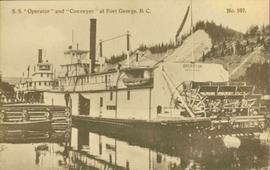
2006.20.9.14
·
Item
·
[ca. 1910]
Part of NBCA Photograph Collection
Postcard photograph depicts two sternwheelers in dock. Group of men can be seen standing on dock. Steep banks of opposite shore visible in background.
Printed annotation on recto reads: “S.S. “Operator” and “Conveyer” at Fort George, B.C. No. 107.”
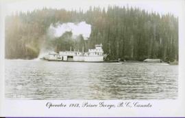
2006.20.9.20
·
Item
·
1913
Part of NBCA Photograph Collection
Postcard photograph depicts sternwheeler in river, trees on opposite shore in background.
Printed annotation on recto reads: “Operator 1913, Prince George, B.C. Canada”, handwritten in pencil on verso: “Operator 1913”.
1994.1.2.1.048
·
File
·
[after 1990]
Part of UNBC Office of External Relations
File consists of photographs of UNBC Staff & Family Portraits .
2008.3.2.4.1
·
Item
·
[1985 or 1986]
Part of Bridget Moran fonds
Photograph depicts group of 23 men and women posed for photo in gymnasium. Plaque in foreground reads "QUINSON ELEMENTARY STAFF 1985 86". Bridget Moran stands third from left in middle row.
1994.1.1.5.4.08
·
Item
·
[2001?]
Part of UNBC Office of External Relations
Videocassette contains a standup by Rob Van Andrichem announcing reruns of "Spotlight on UNBC" for the months of July and August, until the beginning of a new season.
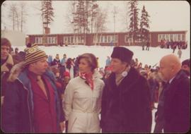
2009.6.1.346
·
Item
·
1978
Part of The Honourable Iona Campagnolo fonds
Handwritten annotation on verso reads: “Northern BC Winter Games ’77 Prince George”.
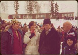
2009.6.1.344
·
Item
·
1978
Part of The Honourable Iona Campagnolo fonds
Long building in background.
Handwritten annotation on verso reads: “with Pierre T + Rob B at P. George, winter 78”.

2012.13.1.129.04
·
Item
·
1975
Part of J. Kent Sedgwick fonds
Image depicts a long line of people cross country skiing along the Birchleg route on Tabor Mountain in Prince George, B.C.

2011.3.4.09
·
Item
·
[ca. 1901-1915]
Part of North Coast & Central BC Postcard Collection
Stern wheeler in river. Printed annotation on recto reads: “Steamer B.X. Monarch of New B.C. Soda Creek, Quesnel and Fort George”
2003.11.1.28
·
File
·
1999-2000
Part of Island Cache Recovery Project Collection
File consists of an oral history given by Stephanie Lode, which was gathered as part of Dr. Mike Evan's Island Cache Recovery Project. Includes consent forms, transcripts, and the recorded oral history on the original media.

2006.20.9.21
·
Item
·
30 October 1910
Part of NBCA Photograph Collection
Postcard photograph depicts lofty view of sternwheeler in river. Scattered buildings and tents in background, river and shore in foreground. Printed annotation on recto reads: “South Fort George Oct 30th 1910”

2012.13.1.7.235
·
Item
·
Mar. 2003
Part of J. Kent Sedgwick fonds
Image depicts a few storage sheds somewhere in Prince George, B.C.
1993.1.2.095
·
Item
·
31 Oct. 2001
Part of UNBC History Collection

2012.13.1.23.11
·
Item
·
1973
Part of J. Kent Sedgwick fonds
Image depicts a small stream somewhere on Cottonwood Island.

2012.13.1.23.07
·
Item
·
1973
Part of J. Kent Sedgwick fonds
Image depicts a small stream somewhere on Cottonwood Island.

2011.3.2.14
·
Item
·
[ca. 1920]
Part of North Coast & Central BC Postcard Collection
Street scene in Prince George B.C. Several Union Jack flags are visible and there is a celebration banner at the end of the street. Long shadows in photo indicate summer (perhaps Dominion Day?). River in foreground, railroad and city in mid ground and hill in background. Printed annotation on recto reads: “Prince George. B.C.”

2012.13.1.7.243
·
Item
·
Apr. 2003
Part of J. Kent Sedgwick fonds
Image depicts a street of houses somewhere in Prince George, B.C.
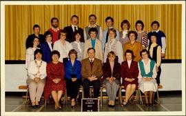
1994.1.2.1.004
·
File
·
[after 1990]
Part of UNBC Office of External Relations
File consists of photographs of the 1997 Student Awards.