Consists of a 1945 handwritten letter from Rev. F.E. Runnalls to Mr. Harvey regarding Runnalls' "History of Prince George" book. Includes two accompanying newspaper clippings.
Prince George, BC
2402 Archival description results for Prince George, BC
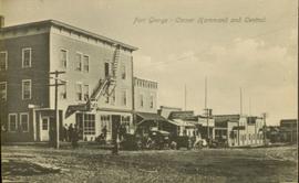
Street view of some vehicles parked in front of commercial buildings in Prince/Fort George. Businesses include "J.P. Robertson 'The Men's Store'" and "James & Co. Clothing and Shoes." Printed annotation on recto reads: "Fort George- Corner Hammond and Central."
File consists of copies of research material related to Island Cache and Cottonwood Island from libraries, museums, and archives. Includes photocopies of public records, photographs, and oral history transcripts.
Item consists of copies of Prince George sister city agreements, likely provided to UNBC for informational purposes.
File consists of photocopies of undated city records related to Island Cache. Includes incoming and outgoing correspondence between the City of Prince George and residents of Island Cache, internal municipal correspondence, a "Report to City of Prince George - Purchases Cottonwood Island Properties", "Cottonwood Island - A Report on Desirable Land Use", and notices of hearings.
File consists of copies of correspondence to residents of Island Cache from the City of Prince George and correspondence from residents of Island Cache to the city.
File consists of copies of records from the City of Prince George from 1974 onwards related to Island Cache that were photocopied and organized by researchers involved with the Island Cache Recovery Project. Includes the 1975 "Cottonwood Island Study" and correspondence regarding a Cottonwood Island trail and park.
File consists of copies of 1973 records from the City of Prince George related to Island Cache that were photocopied and organized by researchers involved with the Island Cache Recovery Project. Includes correspondence from Island Cache residents to the city and correspondence from the city to Island Cache residents regarding purchase and demolition of property.
File consists of copies of 1972 records from the City of Prince George related to Island Cache that were photocopied and organized by researchers involved with the Island Cache Recovery Project. Includes responses to a survey asking home owners of Island Cache about their interest in the installation of a water main to their property. Also includes city correspondence and memoranda regarding the possible installation of a water system in Island Cache.
File consists of copies of 1972 records from the City of Prince George related to Island Cache that were photocopied and organized by researchers involved with the Island Cache Recovery Project. Includes tax assessments for Island Cache properties.
File consists of copies of 1972 records from the City of Prince George related to Island Cache that were photocopied and organized by researchers involved with the Island Cache Recovery Project. Includes real estate indentures between property owners and the City of Prince George for Island Cache properties.
File consists of copies of 1972 records from the City of Prince George related to Island Cache that were photocopied and organized by researchers involved with the Island Cache Recovery Project. Includes correspondence from the city to Island Cache residents and correspondence from Island Cache residents to the city. Much of the correspondence from residents are offers to the city to sell their property.
File consists of copies of 1972 records from the City of Prince George related to Island Cache that were photocopied and organized by researchers involved with the Island Cache Recovery Project. Includes correspondence from persons external to Island Cache, particularly internal city correspondence. Also includes correspondence from other city residents and organizations to the city regarding Island Cache.
File consists of copies of 1972 records from the City of Prince George related to Island Cache that were photocopied and organized by researchers involved with the Island Cache Recovery Project. Includes building inspections and assessments for Island Cache properties. Aldo includes fire inspections and home inventories for insurance purposes.
File consists of copies of 1972 records from the City of Prince George related to Island Cache that were photocopied and organized by researchers involved with the Island Cache Recovery Project. Includes a "Summary of 1972 Cottonwood Island Records", a table of 1972 snow courses, and a listing of insurance claims. Also includes correspondence from residents of Island Cache, City departments, the Cottonwood Island Residents Association, and others.
File consists of copies of 1971 records from the City of Prince George related to Island Cache that were photocopied and organized by researchers involved with the Island Cache Recovery Project. Includes a report on Cottonwood Island by the Advisory Planning Commission, municipal memoranda, a brief on "The Recreation Program on Cottonwood Island", and a brief on the "Reception and Planning Centre". Also includes correspondence from residents of Island Cache, City departments, the Cottonwood Island Residents Association, and others.
File consists of copies of 1970 records from the City of Prince George related to Island Cache that were photocopied and organized by researchers involved with the Island Cache Recovery Project. Includes a petition, a 1970 Cottonwood Island telephone directory, and 1970 census information for Island Cache. Also includes correspondence from residents of Island Cache, School District No. 57, CN Railways, and the Cottonwood Island Residents Association.
File consists of photocopies of 1960s records from the City of Prince George related to Island Cache that were organized by researchers involved with the Island Cache Recovery Project. Includes an Urban Renewal Report and municipal memoranda.
File consists of photocopies of material from the collection of Bob Parris. Includes material dated from 1973 organized by Island Cache Recovery Project researchers. Includes photocopies of photographs, newspaper clippings, correspondence to and from the City of Prince George, records of property assessment, and personal correspondence to Bob Parris.
File consists of photocopies of material from the collection of Bob Parris. Includes material dated from 1972 organized by Island Cache Recovery Project researchers. Includes copies of newspaper clippings, correspondence regarding the installation of a municipal water system on Cottonwood Island, a document of "Thirteen Little-Known Facts About Cottonwood Island", a notice regarding "Clean-up Procedures Following Flooding", Prince George city bylaw no. 2419, a listing of Island Cache properties "Worth Fixing, Maybe Worth Fixing, and Not Worth Fixing", and notices of hearings from the city.
File consists of photocopies of material from the collection of Bob Parris. Includes material dated from 1971 organized by Island Cache Recovery Project researchers. Includes copies of newspaper clippings; a "Report on Flood Protective Measures for Cottonwood Improvement District" from 1969; and newsletters, correspondence, and a petition from the Island Residents' Association.
File consists of photocopies of material from the collection of Bob Parris. Includes material dated from 1970 organized by Island Cache Recovery Project researchers. Includes copies of newspaper clippings, the summary of a Cottonwood Island Community Survey, City of Prince George Letters Patent, Island Residents' Association newsletters, correspondence, and "Cottonwood Island: A Report on Desirable Land Use".
File consists of:
- Draft "Joint Protocol for Co-ordination of Research and Operational Planning Activities at the Aleza Lake Research Forest" between the BC Ministry of Forests, Small Business Forest Enterprise Program, and Northwood Pulp and Timber Ltd. (7 Feb. 1996)
- Application for an Exemption to a Silvicultural Prescription and Logging Plan (19 Dec. 1996)
- Amendment to Special Use Permit #19070, Bowron Floodplain Addition, Aleza Lake Research Forest (1 Aug. 1995)
Videocassette contains raw footage of Convocation May 14, 1994.
Videocassette contains raw footage of Convocation May 14, 1994.
Videocassette contains raw footage of Convocation May 14, 1994.
Videocassette contains raw footage of Convocation May 14, 1994.
Videotape contains footage of: 29-May-05 - Scenery - northwest / 29-May-05 - Convocation - Terrace - Braid, Tammy; Gosnell, Laura; Coosemans, Jose and Amanita / 30-May-05 - Scenery - Nass Valley Lave Lake / 30-May-05 - Convocation - Nisga'a / 30-May-05 - Scenery - Nass Valley near Kincolith and T'seax River
Videotape contains footage of: 28-May-04 - Convocation 2004 / 30-May-04 - Terrace Convocation 2004 - Finlayson, Terri / 31-May-04 - Nisga'a Convocation 2004 / 31-May-04 - UNBC grads run Nisga'a Valley Health Authority - Verde, Mitch; McKay, Corrine
Videotape contains footage of: 24-May-02 - Convocation 2002 / 26-May-02 - Terrace Convocation / 27-May-02 - Hazelton convocation ceremony to recognize recipients of Gitksan language certificates - Woods, Audrey; Jones, Ray
Videotape contains footage of: 1-Jun-01 - Nisga'a Convocation Tape II / 1-Jun-01 - Terrace grad ceremony - Dediluke, Margaret
Videotape contains footage of: 25-May-01 - Convocation Tape II - Johnson, Chris; Ray, Oliver / 31-May-01 - Shawna Hartman fisheries research near Smithers - Hartman, Shawna / 1-Jun-01 - Nisga'a Convocation Tape I - Lincoln, Lillian
Videotape contains footage of: 25-May-01 - Convocation Tape I
Videocassette contains footage of Convocation 2001.
Slide depicts a detonation in an area of cleared ground in a forested area, likely the Aleza Lake Experiment Station. Work may have been undertaken for roadbuilding activities at the Experiment Station.
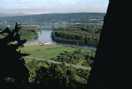
File consists of photographs of the Construction of UNBC with downtown PG visible in the background.
Videotape contains footage of: 3-Nov-05 - Construction of Teaching and Learning Centre / 4-Nov-05 - Oil and Gas video retakes of voiceovers - Rob
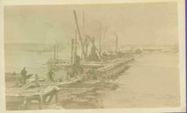
Photograph depicts pier under construction, workers, buildings smokestacks and river with chunks of ice. Handwritten annotation in pencil on recto reads: “S. FT. GEORGE G.T.P. BRIDGE”.
Video is a CG architectural tour of the proposed Northern Medical Program building at UNBC.
File consists of a compilation of digital images on CD-R from the Office of Development.
Series contains material created and collected by Kent Sedgwick over the course of his work with the Prince George Heritage Commission, the Alexander Mackenzie Heritage Trail Association, and other local organizations. The files primarily consist of meeting minutes, typescript documents, and correspondence between Sedgwick and the organizations.
Consists of records relating to the history of the Community Arts Council of Prince George. Includes photograph albums, meeting minutes, and operational records.
This two volume lichen key (I. Arboreal Lichens, II. Terrestrial Lichens) includes original botanical samples of lichen species in the Prince George area. An introductory excerpt is provided below:
Using the Keys:
The keys are designed to permit a non-specialist to identify some of the more common and conspicuous lichens of the Prince George area, with emphasis on those that are used as forage by caribou. It will not be possible to identify all specimens with these keys. Two keys are provided: one for arboreal and one for terrestrial lichens. The arboreal lichen key includes species that grow on living or dead trees or shrubs. The terrestrial lichen key includes species growing on soil or humus, and in a few cases on rock. Some terrestrial lichens may also grow on old, rotten logs on the forest floor. They keys require the use of a hand lens or low-power dissecting microscope. Color descriptions refer to dry lichens.
File consists of 2 Prince George Golden Jubilee (1965) coins and 3 Corporation of the District of Kitimat (1953) coin.
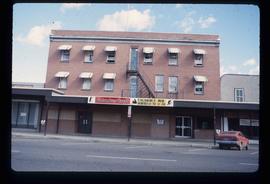
Image depicts the Columbus Hotel in Prince George, which was destroyed by a fire in 2008.
Item is a hand drawn and coloured map by the City of Prince George Planning Department depicting the College Heights and southwest (Vanway) neighbourhood area existing land use in 1976.
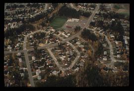
Image depicts College Heights, particularly along Gladstone Drive, in Prince George, B.C.
Subseries consists of various published videos collected by the UNBC Office of Communications for the purposes of background research and the creation of video clips for UNBC productions.
Photograph depicts Colin Browne, Marilyn Bowering, Ken Belford, Sharon Harris, and Joy McKinnon at "Words, Loves" conference.
