Riske Creek, BC

Elements area

Taxonomy

Code

Scope note(s)

    Source note(s)

      Display note(s)

        Hierarchical terms

        Riske Creek, BC

          Equivalent terms

          Riske Creek, BC

            Associated terms

            Riske Creek, BC

              14 Archival description results for Riske Creek, BC

              2012.13.1.65.07 · Item · May 1975
              Part of J. Kent Sedgwick fonds

              Image depicts a sign titled "Chilcotin Wildlife Management Area" somewhere near Riske Creek, B.C. It reads: "This trail has been provided by the Fish and Wildlife Branch in co-operation with Riske Creek Ranching Ltd., as access to the Chilcotin Wildlife Management Area. Please do not leave the the trail as the surrounding land is private property."

              2001.1.090 · File · 1959-1967
              Part of NBCA Document and Ephemera Collection

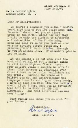
              The fonds consists of 4 letters by Collier written to McKilvington and 1 letter from McKilvington to Collier. Collier's letters discuss the problems in getting a signed copy of his book to McKilvington, and also respond to McKilvington's letter with information about mutual friends in the Chilcotin and with opinions on the depletion of wildlife in the Chilcotin district. McKilvington's letter is autobiographical, and also contains his opinions on the depletion of wildlife in the Chilcotin, gun control and provincial game regulations. One letter is a response to a letter McKilvington sent to the provincial government on the mismanagement of wildlife, ostensibly written by Ken Kiernan (BC Minister of Recreation & Conservation) but, according to Collier, probably written by Jim Hatter, Kiernan's deputy. The newspaper clippings include an obituary of Collier, an article and letter by Collier, and two photographs of Mrs. Collier taken at local functions.

              McKilvington, Benjamin (Bud) W.
              Geographic Features
              2006.20.11 · File · [ca. 1890 - 1940]
              Part of Northern BC Archives Historical Photograph Collection

              Photographs within this file document natural and artificial features across the landscape of Northern British Columbia. This landscape also includes the physical, built, urban and industrial landscapes; topography; site plans; boundaries, districts, reserves, parks, sanctuaries, towns, villages and cities, etc.

              Group of Hikers
              2012.13.1.65.08 · Item · May 1975
              Part of J. Kent Sedgwick fonds

              Image depicts a group of people and two vans, apparently preparing to set out on a hike somewhere near Riske Creek, B.C.

              Group of Hikers
              2012.13.1.65.12 · Item · May 1975
              Part of J. Kent Sedgwick fonds

              Image depicts a group of hikers listening to a man, possibly a guide, speak. The location is possibly near Riske Creek, B.C.

              2012.13.1.65.09 · Item · May 1975
              Part of J. Kent Sedgwick fonds

              Image depicts a group of hikers examining something on the ground, most likely the small pink flower that is barely visible in the grass. The location is possibly near Riske Creek.

              Junction Range
              2012.13.1.065 · Subseries · [between 1974 and 1984]
              Part of J. Kent Sedgwick fonds

              File contains slides depicting places in and around the Junction Sheep Range Provincial Park south-west of Williams Lake.

              Tents
              2012.13.1.65.10 · Item · May 1975
              Part of J. Kent Sedgwick fonds

              Image depicts several orange and blue tents, possibly somewhere near Riske Creek, B.C.