This photograph album consists of photographs, membership cards and correspondence of Herbert F. Glassey. Subjects identified in this album include: automobiles, landscape vistas, hunting scenes, snowshoeing, dog sledding, provincial government offices and waterscapes. Identified geographic locations include: Nesutlane Trading Post, Atlin, Teslin Lake, Atlin Lake, McKee Creek, Taku Glacier and Otter Creek. The following of Mr. Glassey’s membership cards are also included within this album: “White Pass & Yukon Route, No. 308: Government Agent, Atlin account, 1939-1940”; “White Pass & Yukon Route, No. 283: Government Agent account, 1941-1942”; “Registration Certificate, 1940”; “The Wartime Prices and Trade Board, no.1305, 1942”; “Dominion Bureau of Statistics, no.252”; “The Society of Notaries Public Membership Card, 1956”; and “Prince Rupert Liberal Association, 1953”.
Glassey, SarahRed Rock Lake, BC
2 Archival description results for Red Rock Lake, BC
2009.5.2
·
File
·
1899-01-01 - 1959-12-31
Part of Taylor-Baxter Family Photograph Collection
2009.5.2.51
·
Item
·
[ca. 1910?]
Part of Taylor-Baxter Family Photograph Collection
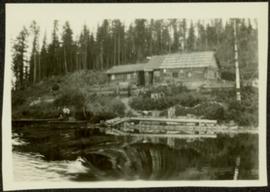
Photograph depicts two log buildings in fenced area on lake shore, forest trees in background. A man can be seen standing near docking area and small boat pier extending into water in foreground. Handwritten annotation on recto of photograph: "Fur Farm Red Rock Lake". This location is believed to at mile 27, north of Summit Lake.
