Transcription:
[Envelope addressed to:]
Mr. George Abbot, 50 State Street, Boston, Mass, U.S.
Brown Bros + Co
[Envelope postmarked from 150 Mile House on Aug 2, 1893 or Aug 2, 1898]
Cariboo Camp, July 31st
Dear Aggie + George
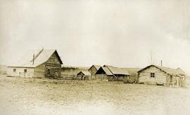
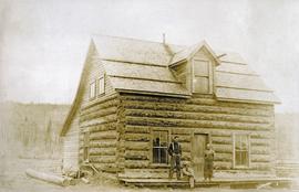
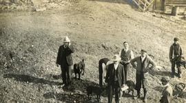
It seems very strange to be all these thousands of miles away, in so short a space of time, and surrounded by conditions so totally different from anything I ever saw, and I find that with all the information received from J.B. that I really knew nothing about it. The journey from Ashcroft was very hard as the roads were so fearfully dusty that for the first 30 miles, I was very much worn out + discouraged and my mouth was parched, nostrils sore, and eyes irritated, for the dust is alkaline, and the water full of it, so that we were very thirsty and yet afraid to drink at the houses on the way, but afterward the wind was in our favour + blew from the north, so it drove the dust behind us and we got along much better. We started on Sunday morning from Ashcroft about 9 a.m. and that day drove 68 miles, with two changes of horses. Monday we drove 75 miles and got within 82 miles of Camp. On Tuesday we drove to within 32 miles of Quesnelle and got there about 11 a.m. and could easily have made the Camp that evening, but found the horses all out in the pasture, which is an enclosure many miles in extent and altho they went in search of horses for 2 or more hours could not find them, so we had to stop all night and the next morning they got the horses, and we got in about 1 p.m. and I met a most hearty reception, as I knew I would, from John, but must say that everyone here (as it is a large colony) are very kind + Mrs Hobson has done everything to make me feel at home. Their house is a perfect burrow of cosiness, and I was perfectly astonished to find things so homelike + delightful. Mrs H has a beautiful flower garden—sweet peas in abundance and a great variety of other flowers looking healthy + fine. They also have a fine vegetable garden, lettuce, peas, cauliflower, onions, beets, potatoes, and all looking fine. Of course they are irrigated, for everything is fearfully dry, and a few days before I got here, John had 150 [men?] fighting fires in the mountains for 3 days + was fearful of the destruction of this Camp, but they saved it by cutting down the timber + back-firing, as they call it, further up the ditch (which I shall see later) they had men cover up or bury with dirt, 40,000th of [illegible] which was saved and one building was burnt and John says the business cost the Company at least $5000.00, but he thinks they got off cheap. I got here on Wednesday + after a good clean up + a good dinner, I went with John to the Mine, and saw the blasting + two Monitors at work, and can assume for it is a most wonderful sight, the [illegible] of the monitors, and the rush of rocks + water thro’ the Flumes is something astonishing, after looking at them a little while, we went back to Camp (for you must know the Mine is more than ½ miles away and after supper had a long talk with John, and he opened a Bottle of Champagne, + I went to bed feeling very tired + happy. Next morning got up about 8 and found [illegible] waiting for me to go to breakfast. Went to the Mines again afterward, after going to the Reservoir + walking down the Ditch, when I saw the clean up of one short piece of Sluice, about 40 or 50 ft in length, it is done by tearing up the Blocks + Riffles, which are laid in a perfectly tight bottom of planks, + a continual stream of water, about 3 inches deep is run thro the sluice box. The men wearing rubber boots + they commence at the top first + follow down, + as they lift the Blocks + Riffles that stop the gold, a man with a peculiar scoop shovel fills the sand + gravel into a pan, and the pan-man lets the water wash it out and the precious stuff then shows in the [shape?] of quicksilver + the gold is enclosed in the same + is amalgam which they carefully put in a sheet iron pail very strongly made. The whole process was interesting + also exciting, on acct of the anxiety as to the result. Well when they got to the end of the clean quicksilver jad been poured back into the flasks over 800 ounces of amalgam, which we brought home with us, and put into the safe. Mind you, I could not tell you how many hundred of feet of Sluice there are, but many, and John says lots of it far richer. [illegible] the ore cleaned, + he expects over $100,000.00 when the final clean up comes, which will be in a week or so for he says he saved the clean up for me to see. It is impossible me to tell you how kind he is to me in every way—and this visit will be to me, a memory as long as I live. There are lots of plans ahead. We are going fishing tomorrow and Horseback rides are planned, then I am going to Horsefly, + spend a night or more there, and I don’t know what beside. Went down to the Mine with John this morning and one of the men brought + handed to me, 2 specimens of coarse gold, which are unusual one some like this [sketch of gold nugget, 2 cm wide] and as large, pure, the other smaller. The larger John says about $2.50. I have found out how exciting a business it must be, especially when you have an interest in what you find. Henry Hobson was very cordial and altho he is much changed, I begin to get familiar with his old look. Robbie is a pretty interesting boy, and takes to me for which I am very thankful as he brings to me my little grandson, J.R. and I tell Robbie about him, and he says he wishes he would come + play with him, he is larger + heavier than J.R. as he weighs 35 lbs. his nurse is a very nice girl, and seems devoted to him he always speaks of her, “as his Mary”. I hope to get letters from home, by next Mail, which will be next Thursday. There is only one Mail a week in here. I have written several disjointed epistles, but I think John telegraphed to your mother that I was safe here from the [illegible] that he said last night that I was not to worry for they knew at home I was all right in Cariboo. They live as well here as at [Jonnys? Jamys?] Hotel, and our party at table is Mr + Mrs H, a Mr Warner, the Doctor, + Henry, and we have about everything you could wish. So you see I have fallen in good hands and I wish it were possible you could see things here as they are, you would be interested + astonished. I trust you + the children are well, and that your mother + Nellie are also well. It seems a long time since I left Lynn and yet it is so short a time since.
The weather here is very fine. The atmosphere invigorating, about 65, and the nights delightfully cool, and conductive to sleep and I am sure it will do me a great deal of good. I suppose George will go on his vacation soon, and am sure he needs it. I wish you could go with him. I often think of you all, hope D + [Odlin?] is home, + the better of his trip, only I trust you will not need his services. I am sure you are easier, when he is [within?] call. Mrs Hobson is going to write Nellie, and send some samples of silk that she wants from Mrs Chase as she could not finish her cushion, not having enough, + she wants her to fold it in a newspaper, but she will tell her about it herself—
I write to you + your mother will see this + Helen, but it is very hard for me to write. I am very anxious to hear from home, but I know it is not time yet so am patient, but shall be most thankful when I hear. Much love to you + George. Kiss Radford + the [illegible] baby for me, love to your mother + Helen, Aunt Aggie + not forgetting Nap—I hope he will keep well, he was not first-rate when I left. Mr + Mrs Hobson both send kindest regards to you all, and now I must stop and am always your affectionate Father
I want both you + George to write.