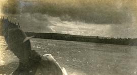
Prince George, BC

Elements area

Taxonomy

Code

Scope note(s)

    Source note(s)

      Display note(s)

        Hierarchical terms

        Prince George, BC

          Equivalent terms

          Prince George, BC

            Associated terms

            Prince George, BC

              2269 Archival description results for Prince George, BC

              2269 results directly related Exclude narrower terms
              Farmhouse
              2012.13.1.3.012 · Item · Apr. 1972
              Part of J. Kent Sedgwick fonds

              Image depicts a farmhouse on Old Summit Road in Prince George, B.C.

              Family Records series
              2014.6.1 · Series · 1953-2017
              Part of Rustad & Dezell Family fonds

              Series consists of records reflecting the activities of the Dezell and Rustad families. Series include mayoral records from Bea and Garvin Dezell when Garvin served as Mayor of Prince George. Series includes materials celebrating Bea Dezell's life created by her family. Series also includes fundraising efforts for the Northern Medical Programs Trust. Finally, series includes a collection of "spruce" dollars and commemorative coins.

              2008.3.3.3.4 · Item · 26 May 1995
              Part of Bridget Moran fonds

              Photograph depicts men, women, and infant seated in the Canfor Theatre at the University of Northern British Columbia in Prince George, B.C. Unidentified individuals sit in seats in background. Accompanying note from Maureen Faulkner: "Next row down is R. [Roseanne Moran] & the Kennedy's, I move to join her next to walkway." Photo taken on the day Bridget Moran received an Honourary Law Degree.

              2008.3.3.3.11 · Item · 26 May 1995
              Part of Bridget Moran fonds

              Photograph depicts men, women, and infant sitting in crowded Canfor Theatre at the University of Northern British Columbia in Prince George, B.C. Accompanying note from Maureen Faulkner: "Your family. now behind R [Roseanne Moran] + me. look on with pride & interest." Photo taken on the day Bridget Moran received an Honourary Law Degree.

              2006.18.1.33 · File · 1994
              Part of Aleza Lake Research Forest Society fonds

              File consists of a compilation of Experimental Projects in the Prince George Region. This compilation work was done by Stewart Taylor of the Ministry of Forests. Included are Experimental Projects regarding the Aleza Lake Research Forest that were selected from Taylor's larger project, which contained over 400 EP summaries for the Prince George Region.

              Exhibition Sports Centre
              2012.13.1.7.234 · Item · Mar. 2003
              Part of J. Kent Sedgwick fonds

              Image depicts the Exhibition Sports Centre, which used to be a drill hall army base, on Keller Street in Prince George, B.C.

              Exhibition Sports Centre
              2012.13.1.7.244 · Item · Mar. 2003
              Part of J. Kent Sedgwick fonds

              Image depicts the Exhibition Sports Centre, which used to be a drill hall army base, on Keller Street in Prince George, B.C.

              2001.1.097 · Item · 1922
              Part of NBCA Document and Ephemera Collection

              Item consists of photocopied pages from the 1922 Wrigley's B.C. Directory. Includes Fort Fraser, Fort George, Fort St. James, Gibson's Landing, Giscome, Giscome Portage, Hutton Mills, Longworth, Loos, Penny, Prince George, Prince Rupert, South Bulkley, South Fort George, and South Francois Lake.

              Everett Peterson
              2006.18.1.08 · File · 2001
              Part of Aleza Lake Research Forest Society fonds

              File consists of:

              • Correspondence from Everett Peterson to Paul Sanborn, dated 6 July 2001, which includes photocopied photographs taken at Aleza Lake in summer 1956
              • Photocopied version of Everett Bruce Peterson's 1956 "Study of Coniferous Reproduction by Direct Seeding Methods on Various Forest Site Types at Aleza Lake, B.C.: An essay submitted during the Third Year of the Course in Forestry at the University of British Columbia" (original is held at NBCA 2007.1.25.3.12)
              Europe Hotel
              2012.13.1.7.178 · Item · Dec. 1999
              Part of J. Kent Sedgwick fonds

              Image depicts the Europe Hotel in Prince George prior to its demolition in the 1980s; however, the slide itself was only made in 1999 and the date of the photo is otherwise unknown, but most likely around 1979.

              2013.9 · Collection · [1930-1939]

              Collection consists of 11 digitized images of Prince George in the 1930s. Includes depictions of snow removal, flooding of the Fraser and Nechako Rivers, the CNR rail yard, and the railway bridge.

              Elsie Christenson
              2003.11.1.05 · File · 1999-2000
              Part of Island Cache Recovery Project Collection

              File consists of an oral history given by Elsie Christenson, which was gathered as part of Dr. Mike Evan's Island Cache Recovery Project. Includes consent forms, transcripts, and the recorded oral history on the original media.

              Elizabeth Williams
              2003.11.1.46 · File · 1999-2000
              Part of Island Cache Recovery Project Collection

              File consists of an oral history given by Elizabeth Williams, which was gathered as part of Dr. Mike Evan's Island Cache Recovery Project. Includes consent forms, transcripts, and the recorded oral history on the original media.

              East Line
              2012.13.2.17 · Subseries · 1972-2011
              Part of J. Kent Sedgwick fonds

              Subseries consists of material collected by Kent Sedgwick for research regarding the communities along the East Line of the Grand Trunk Pacific Railway in Central British Columbia, particularly between Prince George and McBride. These communities and locations include, among others, Shelley, Willow River, Sinclair Mills, Longworth, Dunster, Tete Jaune, Valemount, Mount Robson, and the Yellowhead Pass. Research on these communities was conducted during Kent Sedgwick's involvement in the UNBC-led Upper Fraser Historical Geography Project. The files primarily consist of research notes, audio and transcripts of oral interviews, and photographs of the East Line communities.

              "Dynacom"
              1994.1.1.5.6.08 · Item · [before 1995]
              Part of UNBC Office of External Relations

              Film is a promotional video for Dynacom, the television announcement system installed throughout the UNBC campus.

              Drying sugar
              2014.10.1.104 · Item · 1910
              Part of Arthur Holland Land Surveying Collection

              Photograph depicts a tarp spread out on the grass, two men sit nearby the tarp. There is a canvas tent in the background with a man standing beside it. Behind the tent is a low hill with a fence bordering the top of the hill. There are blankets drying on the fence.

              1993.1.2.041 · File · 2015
              Part of UNBC History Collection

              File consists of:

              • Keynote speech by Dr. Charles Jago to the Northeast BC Resource Municipalities Coalition in Fort St. John on 25 Nov. 2015
              • Speech by Dr. Charles Jago to the Canadian Association of Research Administration Western Canada Branch at UNBC on 4 Dec. 2015
              Jago, Charles
              2012.13.1.3.110 · Item · 12 Oct. 1989
              Part of J. Kent Sedgwick fonds

              Image depicts George St in downtown Prince George with City Hall in the background. Also visible are the Prince George Hotel, Ming's Inn Chinese Restaurant, Fraser Stationers Ltd., Weiner King food cart, and a movie theatre. Map coordinates 53°54'55.0"N 122°44'36.1"W

              2012.13.1.3.108 · Item · 12 Oct. 1989
              Part of J. Kent Sedgwick fonds

              Image depicts 4th Ave at Quebec St, showing the following businesses: The Yarn Barn, Golden Chalice Jewellers, Dandy Lines, Ultrasport, and Saveco. Map coordinates 53°54'58.6"N 122°44'47.5"W

              Downtown Prince George
              2012.13.1.3.082 · Item · May 1984
              Part of J. Kent Sedgwick fonds

              Image depicts downtown Prince George taken from City Hall looking north. Map coordinates 53°54'46.2"N 122°44'43.9"W

              Downtown Prince George
              2012.13.1.3.076 · Item · May 1984
              Part of J. Kent Sedgwick fonds

              Image depicts a view of Prince George from City Hall looking northeast with the pulp mills in the background. Map coordinates 53°54'46.3"N 122°44'41.9"W

              Downtown Prince George
              2012.13.1.3.080 · Item · May 1984
              Part of J. Kent Sedgwick fonds

              Image depicts downtown Prince George taken from City Hall looking north. Map coordinates 53°54'46.2"N 122°44'43.9"W

              Downtown Prince George
              2012.13.1.3.081 · Item · May 1984
              Part of J. Kent Sedgwick fonds

              Image depicts downtown Prince George taken from City Hall looking northwest. Map coordinates 53°54'46.2"N 122°44'43.9"W

              Downtown Prince George
              2012.13.1.3.079 · Item · May 1984
              Part of J. Kent Sedgwick fonds

              Image depicts downtown Prince George taken from City Hall looking northwest. Map coordinates 53°54'46.2"N 122°44'43.9"W