Land, Settlement and Immigration

Elements area

Taxonomy

Code

Scope note(s)

  • Claiming, settling, and moving to a new land

  • Land titles, distribution, grants, etc.

  • Community and regional settlement patterns

  • Land settlement companies

  • Land surveys and surveyors

  • Real estate companies and activities

  • Organizations involved in sponsoring and supporting immigrants

Source note(s)

  • MemoryBC Subject Groups

Display note(s)

    Hierarchical terms

    Land, Settlement and Immigration

      Equivalent terms

      Land, Settlement and Immigration

        Associated terms

        Land, Settlement and Immigration

          1387 Archival description results for Land, Settlement and Immigration

          1387 results directly related Exclude narrower terms
          Optical Discs
          2020.4.9.2 · Subseries · 1995-2013
          Part of G. Gary Runka fonds

          Series consists of digital records on optical disc media (CDs and DVDs) created or collected by Gary Runka and Joan Sawicki for personal and professional purposes. Includes computer back-ups, film documentaries, and digital publications on disc.

          Oral History Interviews
          2003.11.1 · Series · 1999-2000
          Part of Island Cache Recovery Project Collection

          Series consists of the 46 oral histories conducted by the Island Cache Recovery Project. A file exists for each participant in the research project, which includes the original recorded oral history on cassette tape and/or VHS, consent forms for use of the oral history, a written transcript for the oral history, and a digital version of the written transcript. Label on diskette states, "Island Cache Research Project. Transcription of Heinz Bartkowski interview (by: Lori Koop) June 12-99 file: Heinz.rtf FNST 272."

          2009.7.1.277 · Item · [ca. 1880-1920]
          Part of Archdeacon W. H. Collison fonds

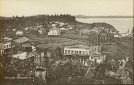
          Wide angle photograph of many buildings scattered in a clear cut area. Foreground shows several businesses, including "Kelly Carruther's Supply" and "Prince Rupert Hardware and Supply Co." Some remaining forest is visible in the background. Annotation on recto reads: "Prince Rupert, BC 1659."

          2020.4.2.1.40 · File · [June 1980]
          Part of G. Gary Runka fonds

          File consists of a speech given by Gary Runka entitled "Overview: Planning for Rural Land" for the Canadian Institute of Planners Annual Conference in Kitchener, Waterloo. Includes newspaper clipping titled "A pathetic tale of two resources" from the Victoria Colonist, June 22,1980.

          Commentary on this speech by Barry Smith of the Ministry of Agriculture and Lands:
          "This speech is aimed at the "urban" planner who is planning in rural areas. While 'rural land' can encompass many things and there are only passing references to agriculture, the planning approaches and principles - like the need for the urban planner to view the world from the rural side of the fence - is often going to involve agricultural land.

          Mention is made of integrated natural resource management and an emphasis is made on the planner understanding the rural perspective.

          The comment (warning) is made that "...the rural land use tug-of-war between lifestyle pursuits, population demands and natural resource production will continue" - the message being that planning practitioners will probably find themselves in the midst of these tug-of-wars.

          This paper clearly recognizes the challenges of introducing urban planning techniques into rural landscapes and provides some very valuable insights. While farmland preservation isn't central to this speech the rural resource and planning theme is relevant."
          Paldi correspondence
          1996.8.4.71 · File · 1991-1998
          Part of Chander Suri fonds

          File consists of correspondence with multiple parties including Wright Parry Taylor & Fuller Engineering, Paldi Estates, and the Cowichan Valley Regional District. Includes notes, sewage and waste disposal assessments, state of title certificate, and applications.

          1996.8.4.72 · File · 1982 -1992
          Part of Chander Suri fonds

          File consists of a development plan for Paldi Estates, a letter about the Paldi Estates Official Community Plan Concept (OCPC), a Bamberton OCPC and town proposal, correspondence from the Cowichan Valley Regional District, highway commercial development schedule, a Stonebridge development permit area, and scans of Registration of Charge applications. Includes design guidelines for rural residential community water systems and a guide for applicants.

          "Paldi New Townsite"
          1996.8.4.70 · File · 1991-1994
          Part of Chander Suri fonds

          File consists of a water supply and sewage disposal study for the townsite of Paldi. Includes maps, correspondence, water licensing information and application, and Bayview Village advertising brochure.

          2012.13.2.20.11 · File · 1981, 2007
          Part of J. Kent Sedgwick fonds

          File consists of typescript documents, notes, and reproductions relating to papers about the 4th Duke of Sutherland in Brooks, Alberta. File contains material regarding the 4th Duke of Sutherland conducting a settlement scheme, through the purchasing and sale of land in Brooks, Alberta. Includes: "The Contribution of the Fourth Duke of Sutherland to the Brooks Community" typescript document by the Brooks Museum (1981).

          "Parcel Z map 1268"
          2012.13.2.02.33.02 · Item · [1990?]
          Part of J. Kent Sedgwick fonds

          The item is a reproduction of a section of survey map drafted in 1915. The reproduction was likely created in 1990. The Plan Number is 1268 and highlights the area along the Nechako River. The map details subdivisions East of Carney Street and North of Fifth Avenue. Some original street and avenue names have been crossed out and replaced with handwritten names. Annotation on reverse side of map states, "D.L. 343 Pl. 1268."

          Park system planning
          1996.8.3.07 · File · 1964-1967
          Part of Chander Suri fonds

          File consists of assorted maps, correspondence, and speeches examining the prospects of park establishment in the Prince George area.

          2003.13 · Collection · [after 1909]

          Consists of two photograph albums that illustrate Parker Bonney's early years as a Forest Engineer. Includes photographs of the expedition to the Nass Valley undertaken by Parker Bonney, Sam Brown, and others. May also include photographs of later surveying expeditions.

          Bonney, Parker
          Pat Foreman
          2003.11.1.13 · File · 1999-2000
          Part of Island Cache Recovery Project Collection

          File consists of an oral history given by Pat Foreman, which was gathered as part of Dr. Mike Evan's Island Cache Recovery Project. Includes consent forms, transcripts, and the recorded oral history on the original media.

          Peace River field trip
          2012.13.2.19.15 · File · 1979-1980
          Part of J. Kent Sedgwick fonds

          File consists of notes and reproductions relating to a field trip in May 1979 for the College of New Caledonia to the Peace River Region, including the Pine Pass lookout; Dawson's Creek; Chetwynd; Hudson's Hope; and the W.A.C. Bennett Dam. Includes: "Peace River" duotang with resources compiled by Kent Sedgwick (1979) and "Bird's eye view of Fort St. John" postcard from Fort St. John (1980).

          Peace River region
          2012.13.2.19.16 · File · 2003-2010
          Part of J. Kent Sedgwick fonds

          File consists of clippings related to the Peace River region. Also includes photographs taken by Kent Sedgwick depicting Mackenzie, BC and the Peace River region (2003).

          Personal Correspondence 1913
          2002.17.3 · Series · 1913
          Part of Henderson-Roe collection

          Consists of 6 letters written by Jack Henderson-Roe, of Fort George, to his father, C.H. Henderson-Roe, of England, regarding proposed land acquisitions in Fort George.

          Personal Correspondence 1914
          2002.17.4 · Series · 1914
          Part of Henderson-Roe collection

          Consists of 5 letters written by Jack Henderson-Roe, of Fort George, to his father, C.H. Henderson-Roe, of England, regarding investments and proposed land acquisitions in Fort George.

          Personal Records
          2020.4.1 · Series · 1953-2014
          Part of G. Gary Runka fonds

          Series consists of records relating to G. Gary Runka's personal life, including academic records, personal resume, and posthumous materials. Also includes Runka's personal correspondence during his time with the Agricultural Land Commission and memorabilia from his curling activities.

          2020.4.2.1.32 · File · Dec. 1983
          Part of G. Gary Runka fonds

          File consists of the written personal reflections of Gary Runka for the "'Ten Years of Agricultural Land Preservation", December 1983.

          Commentary on this speech by Barry Smith of the Ministry of Agriculture and Lands:
          "These personal reflections were prepared by GGR for publication in the ALC's document commemorating its 10th anniversary entitled "Ten Years of Agricultural Land Preservation". These reflections form pages 33 - 35 of this 61 page document.

          The reflections portray the hectic start of the Land Commission's work but also inform us of GGR's role prior to becoming the Commission's first General Manager. As noted, "I had been extensively involved in drawing up the "suggested ALR plans" for the various regional districts while working with the Soils Branch of the Ministry of Agriculture." He then accompanied the Commission on their initial meetings with regional districts and local governments around the province.

          The fact that GGR played a key role in developing the CLI mapping (an important basis of the ALR), then was involved with drawing up the suggested ALR plans, followed by his efforts as ALC General Manager to implement the Reserve plans, and finally sign off on the completed ALR plan map sheets, arguably makes Gary Runka, like no other person, the "Father of the ALR"."

          2020.4.4.03 · File · 1978
          Part of G. Gary Runka fonds

          File consists of records relating to the Perspectives on Natural Resources Symposium II Land in Lindsay, ON, November 8, 1978, which Gary Runka spoke at in his role as Chairman of the BC Agricultural Land Commission. Includes correspondence, speaking notes, conference material, and papers. Runka's paper was "Private Land Needs and the British Columbia Agricultural Land Commission Experience".

          Photographs
          2020.4.8 · Series · 1956-2013
          Part of G. Gary Runka fonds

          Gary Runka was a hobbyist photographer and documented his work and personal life through photography as he travelled across every region of British Columbia. His photographs document the evolution of British Columbia communities and regions over a 30 year period. Gary Runka's core interest was land and changing land uses. Many of his photographs tell a story of urban edge and/or natural resource compatibility/conflict. There are also a substantial number of photographs related to soils, including soil profiles, soil erosion and land (topography, drainage etc.) capability for agriculture. The collection also includes specific client-related photos, tied to Land Sense Ltd. client file job numbers.

          The collection also documents personal travels and hiking trips throughout British Columbia and backpacking in some historic areas, such as the West Coast Trail and Cape Scott. These photographs also represent land evolution over time, including extent of alpine glaciation or biodiversity/plant species inhabiting the area.

          Photographs
          2003.13.1 · Series · [after 1909]
          Part of Parker Bonney Photograph Collection

          Consists of two photograph albums that illustrate Parker Bonney's early years as a Forest Engineer. Includes photographs of the expedition to the Nass Valley undertaken by Parker Bonney, Sam Brown, and others. May also include photographs of later surveying expeditions.

          Photographs
          2002.17.1 · Series · [between 1912 and 1914]
          Part of Henderson-Roe collection

          Photographs consist of 16 black & white photographs depicting Fort George land and surveying, including 3 photographs of Jack Henderson-Roe in front of his log cabin that he constructed in Fort George in 1913.

          2020.4.2.1.10 · File · Apr. 1974
          Part of G. Gary Runka fonds

          File consists of a speech given by Gary Runka entitled "Physical Resource Data Needs in Land Use Planning" which was given at a technical workshop to develop an integrated approach to base data inventories for Canada's Northland.

          Commentary on this speech by Barry Smith of the Ministry of Agriculture and Lands:
          "While the speech is not related to agriculture or farmland preservation directly, GGR emphasises the importance of data collection and mapping and its use in the planning process. The general principles he discusses were those employed in the development of the Agricultural Land Reserve.

          The proceedings of the workshop were published in 1979 by Environment Canada." The proceedings are available online at: https://www.geostrategis.com/PDF/1974-04-17%20remote%20sensing%20for%20northen%20surveys%20and%20environmental%20monitoring-jean%20Thie%20CCRS%20copy.pdf

          Pl. 721 DL 1426
          2012.13.2.02.33.15 · Item · [1990?]
          Part of J. Kent Sedgwick fonds

          The item is a reproduction of a survey map likely drafted in the 1910s. The reproduction was likely created in 1990. The area covered is South of Anderson Street, East of Simpson Street, North of Van Bien Avenue and West of 9th Street. Annotations state, "Pl 721 DL 1426."

          2012.13.2.02.33.08 · Item · [1990?]
          Part of J. Kent Sedgwick fonds

          The item is a reproduction of a survey map drafted in July 1914. The reproduction was likely created in 1990. The area covered is along the Fraser River and east of Guelph Street. Annotations state, "PL 1409 D. L. 417 HBCo." and highlight different scales of measurement and changed street names.

          2012.13.2.02.33.12 · Item · [1990?]
          Part of J. Kent Sedgwick fonds

          The item is a reproduction of a survey map drafted on 29 Oct. 1910. The reproduction was likely created in 1990. The area covered is South of Princess Street, East of James Avenue, North of 8th Street and West of Rupert Avenue. Annotations state, "Jesse Hodgeson Crown grand in 1910 for $800..."

          2012.13.2.02.33.09 · Item · [1990?]
          Part of J. Kent Sedgwick fonds

          The item is a reproduction of a survey map drafted in 1 Oct. 1913. The reproduction was likely created in 1990. The area covered is along the Fraser River and west of Linooln Avenue, south of Jackson Street and North of McKinley Street. Annotations state which maps and lots are adjacent to this one. An illegible signature is highlighted.

          2012.13.2.02.33.16 · Item · [1990?]
          Part of J. Kent Sedgwick fonds

          The item is a reproduction of a survey map drafted on 1 March 1910. The reproduction was likely created in 1990. The area covered is South of Bernhardt Avenue, East of Simpson Street, North of the Fraser River and West of 9th Street. Annotations state, "DL 1426 Plan 721."

          2012.13.2.02.33.03 · Item · [1990?]
          Part of J. Kent Sedgwick fonds

          The item is a reproduction of a survey map drafted on 1 March 1910. The reproduction was likely created in 1990. The area highlighted is along the Fraser River. The map details subdivisions East of Ninth Street and South of Thapage Lane. Land Surveyor J. F. Templeton certified the plan. Annotation on the map states, "Pl. 727."