Title and statement of responsibility area
Title proper
General material designation
Architectural drawing
Cartographic material
Graphic material
Textual record
Parallel title
Other title information
Title statements of responsibility
Title notes
- Source of title proper: Title based on creator of fonds.
Level of description
Reference code
Edition area
Edition statement
Edition statement of responsibility
Class of material specific details area
Statement of scale (cartographic)
Statement of projection (cartographic)
Statement of coordinates (cartographic)
Statement of scale (architectural)
Issuing jurisdiction and denomination (philatelic)
Dates of creation area
Date(s)
-
1954-2009 (Creation)
- Creator
- Suri, Chander
Physical description area
Physical description
- 1.38 m of textual records
- approx. 2000 maps and plans
- approx. 70 photographs
Publisher's series area
Title proper of publisher's series
Parallel titles of publisher's series
Other title information of publisher's series
Statement of responsibility relating to publisher's series
Numbering within publisher's series
Note on publisher's series
Archival description area
Name of creator
Biographical history
Chander Suri was the planning director for the Regional District of Fraser Fort George from 1969 to 1977. Graduating from Delhi University in 1962 with a Bachelor of Architecture Degree, Suri worked on multiple projects worldwide including townships in Hungary, Tokyo, Czechoslovakia, England, Japan, and New Delhi. He was also a lead designer on the United States pavilion at the 1961 New Delhi International Fair and the Quebec pavilion for Expo 67.
Suri started his career with the Regional District of Fraser Fort George in early 1968, working as a planning assistant with Alan Soutar. In March 1969, Chander Suri was appointed planning director in his predecessor's place and tasked with overseeing multiple development plans for Prince George and the Fraser Fort George Regional District. He started his term managing the establishment of development centers and recreational sites along Highway 16 East to take advantage of the tourist traffic anticipated with the route's completion. Additionally, Suri oversaw the development of the Greater Prince George Plan unveiled in 1974, outlining a 25-year development plan for the city.
Numerous other projects mark his employment with the Regional District including Official Community Plans for the Fraser Fort George Regional District and surrounding Upper Fraser Valley communities. Suri's work encompassed rural planning, property assessments, land use policy, real estate, park system planning, and development projects connected to resource management and waste management. His employment with the Regional District ended in 1977. Suri continued to work as a Prince George-based independent planning consultant thereafter.
Custodial history
Donated by Chander Suri to the University of Northern British Columbia in 1996. Accrual received in 2018.
Scope and content
This fonds encompasses the planning career of Chander Suri. The head planner for the Regional District of Fraser-Fort George from 1969 to 1977, Chander Suri embarked on numerous community plan projects in the Prince George area. Suri also worked as an independent planning consultant for local businesses and organizations. Chander Suri's records encompass numerous urban and rural projects facilitating population and industry growth within the RDFFG that spanned beyond Suri's career.
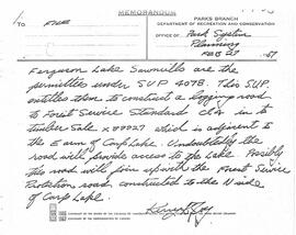
Textual records comprise official and draft planning documents, development reports, planning proposals, contracts, published regulations, socio-economic studies of regions near Prince George, financial and other studies for development sites, illustrated promotional packages/proposals for developments, regional/provincial guides and standards, and correspondence relating to Suri's professional consulting activities. The fonds contains a wide array of maps, architectural plans, and technical drawings ranging from municipal planning layouts, industrial land developments, and private property (commercial and residential) development projects, mainly from in and around Prince George.
These records are relevant to researchers of the subjects of land use, land development and land planning issues in the Prince George and Fraser-Fort George Regional District in the second half of the 20th century.
Series include:
- Maps and Plans relating to development projects in British Columbia, predominantly in the Prince George area
- Lower Mainland Planning material from Suri's early career period
- Regional District of Fraser Fort George Planning records and resource material collected by Suri during his employment at the RDFFG
- Planning Consultancy records relating to Suri’s independent planning consultancy work in his later career period
Notes area
Physical condition
Immediate source of acquisition
Arrangement
Arranged by the archivist.
Language of material
English
Script of material
Location of originals
Availability of other formats
Restrictions on access
No restrictions.
Terms governing use, reproduction, and publication
Personal or academic use of materials is welcomed under the standard fair dealing and educational use clauses of Canadian Copyright Law. Commercial use is, however, forbidden without the express permission of the copyright holder. For information on obtaining written permission from the copyright holder, please contact the Northern B.C. Archives and Special Collections.