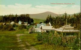
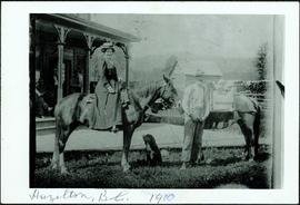
Hazelton, BC

Elements area

Taxonomy

Code

Scope note(s)

    Source note(s)

      Display note(s)

        Hierarchical terms

        Hazelton, BC

          Equivalent terms

          Hazelton, BC

            Associated terms

            Hazelton, BC

              126 Archival description results for Hazelton, BC

              126 results directly related Exclude narrower terms
              2009.5.1.52 · Item · [ca. 1905]
              Part of Taylor-Baxter Family Photograph Collection

              Hugh Taylor Sr. stands between two horses, holding reigns. Hermina sits on left horse, Ellen and Violet sit in packboard on right horse. Five men sit on deck of large building with detailed porch in background on left. A fence, log shed, and wood pile can be seen in background on right. A dog stands beside Hugh. Handwritten annotation on verso of photograph: "Hazelton, B.C. 1910."

              Inlander Hotel
              2012.13.1.51.060 · Item · May 1973
              Part of J. Kent Sedgwick fonds

              Image depicts the Inlander Hotel in Hazelton, B.C. The peak of the Rocher de Boule mountain is visible in the background.

              2020.05.13 · Item · [Sept. or Oct. 1936]
              Part of Gordon Wyness Album

              Photograph depicts (from left to right) Jack Lee, Gordon Wyness, Jessie McInnes, and Archie McInnes at Pioneer Ranch.

              In 1903, brothers Neil and Archie McInnes pre-empted a section of land two miles east of Cote Flat, each taking half. Archie McInnes' land later became known as Pioneer Ranch (later known as the Barnett Ranch); Neil McInnes' land became Meadowbrook Ranch. Archie McInnes married Jessie Aitken in October 1905. Pioneer Ranch became known as a stop-over for travellers en route from Hazelton to the Ootsa Lake area via the Telegraph Trail. Archie and Jessie McInnes had three daughters: Vera (m. Ivan Frank), Ivy (m. Eric Strimbold), and Neva (m. John Ivan Nickolichuk).

              2020.05.14 · Item · [Sept. or Oct. 1936]
              Part of Gordon Wyness Album

              Photograph depicts (from left to right) Jack Lee, Philip Monckton, Jessie McInnes, and Archie McInnes at Pioneer Ranch.

              In 1903, brothers Neil and Archie McInnes pre-empted a section of land two miles east of Cote Flat, each taking half. Archie McInnes' land later became known as Pioneer Ranch (later known as the Barnett Ranch); Neil McInnes' land became Meadowbrook Ranch. Archie McInnes married Jessie Aitken in October 1905. Pioneer Ranch became known as a stop-over for travellers en route from Hazelton to the Ootsa Lake area via the Telegraph Trail. Archie and Jessie McInnes had three daughters: Vera (m. Ivan Frank), Ivy (m. Eric Strimbold), and Neva (m. John Ivan Nickolichuk).

              Jean Caux's Pack Train
              2009.5.1.77 · Item · 1897
              Part of Taylor-Baxter Family Photograph Collection

              Photograph consists of Jean Caux and several men loading supplies onto a horse and mule pack train. Large building in background. Annotation along bottom recto of photograph reads: "Jean Caux's Pack Train, loading at Harvey Baileys for Babine Lake - 1897." Handwritten annotations on recto of photograph: "CATALINE 1897" "Born in 1856 in Mexico on Spanish border. Died at Hazelton 1922 burried in old cemetery."

              2009.5.1.78 · Item · 1909
              Part of Taylor-Baxter Family Photograph Collection

              Photograph depicts men loading a line of approximately twenty mules facing large building in background with the sign: "[WBBAILEY?] ANDCO'S OFFICE." A second sign is posted on deck of building: "ALWAYS CURES! CHAMBERLAIN'S COUGH REMEDY." More men wearing suits watch from deck. Small building in hillside can be seen in background. Annotation along bottom recto of photograph reads: "Last Pack Train leaving Ashcroft for Hazelton -1909." Handwritten annotation on recto of photograph: "CATALINE 1909".

              'Ksan
              2012.13.1.51.014 · Item · Aug. 1971
              Part of J. Kent Sedgwick fonds

              Image depicts the historical village of 'Ksan near Hazelton, B.C.

              'Ksan
              2012.13.1.51.074 · Item · [1973?]
              Part of J. Kent Sedgwick fonds

              Image depicts the 'Ksan historical village in Hazelton, B.C.

              'Ksan
              2012.13.1.51.075 · Item · [1973?]
              Part of J. Kent Sedgwick fonds

              Image depicts the 'Ksan historical village in Hazelton, B.C.

              'Ksan
              2012.13.1.51.101 · Item · Aug. 1976
              Part of J. Kent Sedgwick fonds

              Image depicts the historical village of 'Ksan in Hazelton, B.C.

              'Ksan
              2012.13.1.51.026 · Item · May 1972
              Part of J. Kent Sedgwick fonds

              Image depicts a group of people in the historical village of 'Ksan near Hazelton, B.C.

              'Ksan - Longhouse Interior
              2012.13.1.51.061 · Item · May 1973
              Part of J. Kent Sedgwick fonds

              Image depicts a large gathering of people in the interior of a First Nations' longhouse located in the historical village of 'Ksan in Hazelton, B.C.

              2009.5.1.86 · Item · 13 October 1911
              Part of Taylor-Baxter Family Photograph Collection

              Handwritten annotation on recto of photograph: "Frank [Johnstron?] Oct. 13th/11 Hazelton BC". Photograph depicts Frank sitting in suit and hat with dog on a wood walkway, unidentified building in background on left. Wood pile is visible behind them.

              2009.7.1.314 · Item · [ca.1880-1920]
              Part of Archdeacon W. H. Collison fonds

              Photograph of a long bridge spanning two rock faces. Below is a smaller, half demolished wooden bridge. A small settlement is visible on the lower right. Annotation on recto reads: "Haquelqet Bridge." Handwritten annotation on verso reads: "Old & New. Old Indian built bridge & later one at Hazelton, BC."

              2002.1 · Collection · 1887-1999

              The Prince George Railway & Forestry Museum Society Collection consists primarily of textual, photographic, and cartographic records related to the regional developments of the railway industry in Northern BC. A predominant portion of the collection is made up of material from the Canadian National Railway; other railways represented include the Pacific Great Eastern Railway, the British Columbia Railway (BC Rail), the Grand Trunk Pacific Railway, the Grand Trunk Railway, the Intercolonial Railway, and the Okanagan Express. Significant geographical areas covered include Prince George, the Peace River Region, Terrace, Bulkley Valley, Hazelton and Prince Rupert.

              The forestry industry is represented in the collection with operational and financial records from Fyfe Lake Sawmill Ltd., which operated southwest of Prince George in the 1950s.

              The collection has been organized into series according to creator, each of which also has been arranged to subseries, file and item level, where applicable. This collection consists of eight series, as follows:

              1) Canadian National Railway
              2) Grand Trunk Railway
              3) Pacific Great Eastern Railway
              4) British Columbia Railway (BC Rail)
              5) Canadian Pacific Railway (CPR)
              6) Intercolonial Railway
              7) Fyfe Lake Sawmill ltd.
              8) PGRFM
              9) Photographs

              2009.5.1.74 · Item · [after 1912]
              Part of Taylor-Baxter Family Photograph Collection

              Photograph depicts the Grand Trunk Pacific Railway Bridge crossing the Bulkley River. A smaller bridge speculated to be used by pedestrians stands below and parallel to the railway bridge. Photo was taken from shore, with opposite shore crossing midground. Trees in foreground, mountains in background. A small building can be seen at opposite end of bridge. Other sections of railway can be seen on hill in background. Handwritten annotation on verso of photograph: "HAZELTON BULKLEY BRIDGE."

              2009.6.13.45.18 · Item · 1976
              Part of The Honourable Iona Campagnolo fonds

              Map depicts the regional district of Kitmat, but is extensively annotated showing the proposed route of the Kitmat Truck Ferry, running through Terrace and up into the "Yukon Markets," and the Kispiox Connector, running from Prince Rupert to Hazelton and further East along Highway 16 and north along the Kispiox River.