Elements area
Taxonomy
Code
Scope note(s)
Source note(s)
Display note(s)
Hierarchical terms
Haida Gwaii, BC
Equivalent terms
Haida Gwaii, BC
- UF Queen Charlotte Islands, BC


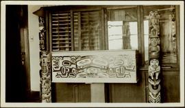
Two model totem poles flank a bentwood box sitting on a pedestal in front of a bookcase in the office of W.E. Collison. Handwritten annotation in pen on verso reads: “Totem & carved chest in Dad’s office.”
Series consists of images pertaining the Collison family, North Coastal First Nations communities, means of transportation along North Coastal British Columbia, and various church structures and religious events.
Collection consists of a travel scrapbook created by Jill Singleton documenting a trip to Alaska, Yukon, Haida Gwaii, and northern BC. Includes photographs, ephemera, handwritten notes, pamphlets, issues of local newspapers, and maps.
File consists of documents recording the founding, funding, explorations, and investments of the pioneering Queen Charlotte Islands General Development Company, Ltd. (London, England). Includes approximately 150 pages of manuscript and the following items of interest:
This unpublished manuscript, authored by W.H. Collison and handwritten by Joyce Collison, comprises 29 identifiable chapters. Content of this manuscript appears to be focused upon the retelling of First Nations stories. The donor identified that this manuscript was intended for publication but was never completed.
Series contains publications on the following subjects: linguistics, First Nations studies, anthropology, museum studies, the Missionary Society of the Church of England, the Metlakatla Inquiry, material culture and Canadian geography. It is believed that items published prior to 1922 had been collected by the Archdeacon W.H. Collison, while those published post 1922 (the year W.H. Collison passed away) were collected by both his son W.E. Collison and then his grandaughter Joyce Collison.
The Archdeacon W.H. Collison fonds consists of textual materials, maps, published materials and photographs all documenting Collison’s life and work with North Coastal First Nations communities in British Columbia. Types of records found within this fonds include manuscripts, sermon notes, correspondence, oral history summaries, monographs, cartographic items, photographs and postcards. The Collison fonds also includes some records created by his children and grandchildren as well as a family tree created in 1986. The Collison fonds has been divided into four series.
Collison, W.H. (Archdeacon)Maps within this series document the placer streams, islands and harbours of the Queen Charlotte Islands; as well as the mining properties located within the vicinity of Stewart, BC.
File predominantly consists of correspondence to Rev. W.H. Collison from the Church Missionary Society. However, some letters in this file are also from individual parishioners, fellow clergymen, Massett councillors, and the American Geographical Society.
This file contains handwritten and typed notes and drafts of First Nations legends, addresses and manuscripts. It is believed this material was authored by W.H. and W.E. Collison although none is signed or dated.
Notebook contains Collison's recollections of local history as he heard it, and of the events he encountered during some of his time in ministry.
Notebook contains two stories: "The Finding of the Crystals" and "Tit for Tat or The Porcupine and the Beaver". These stories are also found in the Collison manuscript.
Small booklet containing handwritten notes of what appears to be a speech prepared by W.H. Collison on the topic of traditions and events he had been witness to along the northwest coast of British Columbia.
File includes "In the Wake of the War Canoe" Chapter XX revisions and a note from donor Jean Whiffin on behalf of Joyce Collison regarding the revisions.
File contains linguistic notes prepared by W.H. Collison and sermons written by W.H. Collison in various First Nations languages.
File consists of records created and accumulated by Gary Runka over the course of his consultancy work for Queen Charlotte Islands Forest District for the "Facilitation and Mediation of Local Resource Use Plan for Tlell Watershed" project in Tlell River. This file was numbered as G.G. Runka Land Sense Ltd. client file #539; that client number may be seen referenced elsewhere in the G. Gary Runka fonds. The Land Sense Ltd. client files generally include records such as correspondence, contracts, invoices, project reports, publications, ephemera, memoranda, maps or map excerpts, legal documents, meeting materials, clippings, and handwritten notes.
Maps include:
File consists of records created and accumulated by Gary Runka over the course of his consultancy work for Misty Isles Economic Development Society for the "Food Planning Presentations on Haida Gwaii" project in Haida Gwaii. This file was numbered as G.G. Runka Land Sense Ltd. client file #664; that client number may be seen referenced elsewhere in the G. Gary Runka fonds. The Land Sense Ltd. client files generally include records such as correspondence, contracts, invoices, project reports, publications, ephemera, memoranda, maps or map excerpts, legal documents, meeting materials, clippings, and handwritten notes.
File consists of records created and accumulated by Gary Runka over the course of his consultancy work for Haida Tribal Society for the "Facilitation and Process Advice on Development of a Marine Use Strategic Plan" project in Haida Gwaii. This file was numbered as G.G. Runka Land Sense Ltd. client file #626; that client number may be seen referenced elsewhere in the G. Gary Runka fonds. The Land Sense Ltd. client files generally include records such as correspondence, contracts, invoices, project reports, publications, ephemera, memoranda, maps or map excerpts, legal documents, meeting materials, clippings, and handwritten notes.
File consists of records created and accumulated by Gary Runka over the course of his consultancy work for BC Ministry of Sustainable Resource Management for the "Consultations on Land Use Planning Process Design Haida Gwaii/QCI Land Use Plan" project in Queen Charlotte City. This file was numbered as G.G. Runka Land Sense Ltd. client file #579; that client number may be seen referenced elsewhere in the G. Gary Runka fonds. The Land Sense Ltd. client files generally include records such as correspondence, contracts, invoices, project reports, publications, ephemera, memoranda, maps or map excerpts, legal documents, meeting materials, clippings, and handwritten notes.
File consists of records created and accumulated by Gary Runka over the course of his consultancy work for Natural Resources Canada & BC Ministry of Forests for the "Facilitation of South Moresby Forest Replacement Account Strategic Plan Negotiations" project in Haida Gwaii. This file was numbered as G.G. Runka Land Sense Ltd. client file #543; that client number may be seen referenced elsewhere in the G. Gary Runka fonds. The Land Sense Ltd. client files generally include records such as correspondence, contracts, invoices, project reports, publications, ephemera, memoranda, maps or map excerpts, legal documents, meeting materials, clippings, and handwritten notes.
This travel scrapbook was created by Jill Singleton to document a trip to Alaska, Yukon, Haida Gwaii, and northern BC. Jill Singleton and Eric Stathers embarked on a 1985 car camping trip using the BC Ferries and Alaska Ferry systems. Includes postcards, ephemera, handwritten notes, pamphlets, issues of local newspapers, and maps. Also includes 37 photographs.
Includes the following:
Trip itinerary:
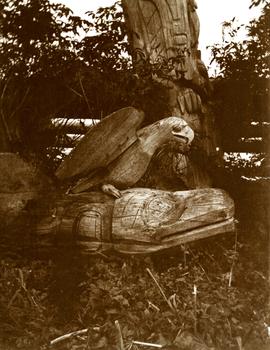
Carvings sit among bushes in front of what appears to be a totem pole.
Handwritten annotation on verso reads: "Eagle & whale Monument Tanu".
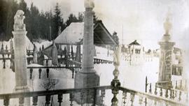
Photograph depicts a snow covered cemetery with gravestones, tombstones, and monuments.
Handwritten annotation on verso of photograph reads: "W.E. Collison Masset. Interior of Chief [Weah's?] house".
Caption under printed version of photo in W.H. Collison's book 'In the Wake of the War Canoe': "The house is about 40 feet square, forming one large room. The upper cubicles are on a level with the ground, which in front of them is excavated so that the fireplace in the centre is twelve feet below the surface. A ledge, for the use of slaves and dependents, is left half-way down."
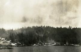
Photograph depicts a dock and building near the water. A few buildings are being constructed on some newly cleared land nearby.
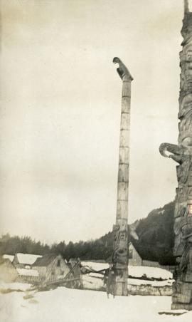
Photograph depicts two tall totem poles, buildings and mountain in the background.
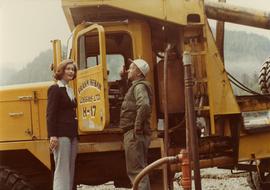
Photograph depicts Iona Campagnolo talking with an unidentified employee of Frank Beban Logging while standing beside a large piece of heavy machinery.
Photograph depicts Iona Campagnolo signing the cast of an unidentified constituent. Several other unidentified constituents surround them. Taken during Campagnolo's Skeena riding tour in Haida Gwaii, British Columbia.
Photograph depicts Iona Campagnolo standing and talking in a group of unidentified seated constituents. Taken during Campagnolo's Skeena riding tour in Haida Gwaii, British Columbia.
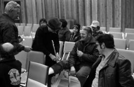
Photograph depicts Iona Campagnolo siting and talking with a group of unidentified seated constituents. The woman beside her looks down. Taken during Campagnolo's Skeena riding tour in Haida Gwaii, British Columbia.
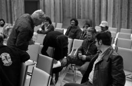
Photograph depicts Iona Campagnolo signing the cast of an unidentified constituent. Several other unidentified constituents surround them. Taken during Campagnolo's Skeena riding tour in Haida Gwaii, British Columbia.
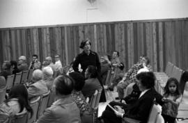
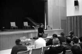
Photograph depicts Iona Campagnolo talking with unidentified constituents at a community meeting in an auditorium. The unidentified constituents, with most of their backs to the camera, are in the foreground. Taken during Campagnolo's Skeena riding tour in Haida Gwaii, British Columbia.
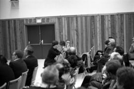
Photograph depicts Iona Campagnolo talking with unidentified constituents at a community meeting in an auditorium. The constituents, with their backs to the camera, are in the foreground. Taken during Campagnolo's Skeena riding tour in Haida Gwaii, British Columbia.
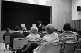
Photograph depicts Iona Campagnolo talking with unidentified constituents at a community meeting in an auditorium. The constituents, with their backs to the camera, are in the foreground. Taken during Campagnolo's Skeena riding tour in Haida Gwaii, British Columbia.
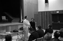
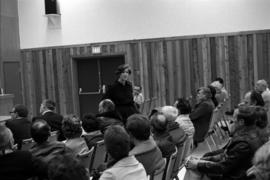
Photograph depicts Iona Campagnolo talking with unidentified constituents, largely male, at a community meeting in an auditorium. Taken during Campagnolo's Skeena riding tour in Haida Gwaii, British Columbia.
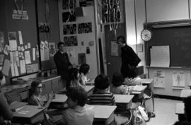
Photograph depicts Iona Campagnolo talking to a class of elementary school children about the Canada Fitness Award program in Haida Gwaii during Campagnolo's Skeena Riding Tour of Haida Gwaii, BC. An unidentified adult (possibly a teacher) is in the far right corner.
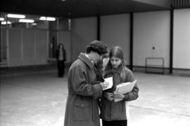
Photograph depicts Iona Campagnolo standing outside the school and signing an autograph for an unidentified female student during Campagnolo's Skeena Riding Tour of Haida Gwaii, BC.
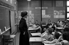
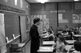
Photograph depicts Iona Campagnolo talking to a class of elementary school children about the Canada Fitness Award program in Haida Gwaii during Campagnolo's Skeena Riding Tour of Haida Gwaii, BC. Several unidentified adults are in the far right corner.
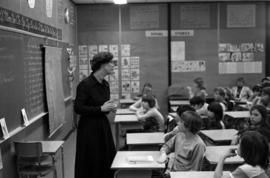
Photograph depicts Iona Campagnolo talking to a class of elementary school children about the Canada Fitness Award program in Haida Gwaii during Campagnolo's Skeena Riding Tour of Haida Gwaii, BC. Several unidentified adults are in the far right corner.
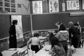
Photograph depicts Iona Campagnolo talking to a class of elementary school children in Haida Gwaii during Campagnolo's Skeena Riding Tour of Haida Gwaii, BC. The majority of the children are standing and facing away from the camera.
Photograph depicts Iona Campagnolo and an unidentified teacher talking to a class of elementary school children in Haida Gwaii during Campagnolo's Skeena Riding Tour of Haida Gwaii, BC. The children are in the foreground and the majority are not facing the camera.
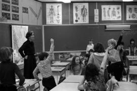
Photograph depicts Iona Campagnolo talking to a class of elementary school children in Haida Gwaii during Campagnolo's Skeena Riding Tour of Haida Gwaii, BC. Several of the children are raising their hands.
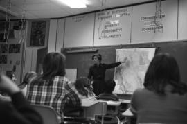
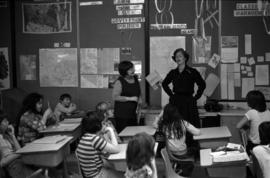
Photograph depicts Iona Campagnolo pointing at a map of British Columbia and talking to a class of elementary school children in Haida Gwaii during Campagnolo's Skeena Riding Tour of Haida Gwaii, BC. The children are in the foreground with their backs to the camera.
Photograph depicts Iona Campagnolo standing beside a map of British Columbia and talking to a class of elementary school children in Haida Gwaii during Campagnolo's Skeena Riding Tour of Haida Gwaii, BC. The children are in the foreground with their backs to the camera.
Photograph depicts Iona Campagnolo and an unidentified teacher talking to a class of elementary school children in Haida Gwaii during Campagnolo's Skeena Riding Tour of Haida Gwaii, BC. The children are in the foreground with their backs to the camera.
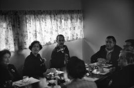
Photograph depicts Iona Campagnolo and six unidentified others eating at a restaurant during Campagnolo's Skeena Riding Tour in Haida Gwaii, BC.
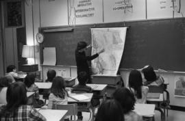
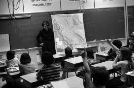
Photograph depicts Iona Campagnolo marking an area on a map of British Columbia to a class of elementary school children in Haida Gwaii during Campagnolo's Skeena Riding Tour of Haida Gwaii, BC. The children are in the foreground with their backs to the camera.