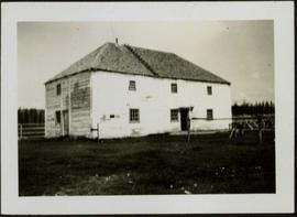
Photograph depicts a large two story building in fenced area. Field spans foreground, stand of trees in background. Handwritten photo caption below photograph reads: "The old warehouse." It is believed that this photograph may have been taken at Fort St. James, BC.
Fort St. James, BC
65 Archival description results for Fort St. James, BC
Exterior side view of a Catholic church built between 1876-1878 by Father George Blanchet. Handwritten annotation on verso in pencil reads: “Our Lady of Good Hope, Stuart Lake, Fort St. James, BC ”
Photograph depicts two First Nations men and two pack dogs loaded with bags. A small group of people can be seen in distance in front of semi-visible building. Stand of trees in background. Handwritten photo caption below photograph reads: "Indians & Pack Dogs - Fort St. James."
This file consists of photocopy reproductions of research material relating to the Missionary Oblates of Mary Immaculate (OMI) in Northern British Columbia, the Stuart Lake Mission, and the Our Lady of Good Hope Church in Fort St. James. Includes:
- Informational email from William O'Hara about the Our Lady of Good Hope Church in Fort St. James, 2014
- Reproduction of article by Bill O'Hara, "Our Lady of Good Hope Church first used at Christmas, 1878" from the Caledonia Courier, 17 Dec 1997
- Reproduction of "Missions de la congrégation des missionnaires oblats de Marie Immaculée - Dix-huitieme Année - No. 69. - Mars 1880" [French], a report that includes mention of "les Babines", "les Sékénés" [Sekani], "les Hotsoten" [Wet'suwet'en], Stuart Lake, Fort George, McLeod Lake, Babine Lake, among others
Image depicts an old tomb stone at an uncertain location, possibly Fort St. James, B.C.
File consists of trail maps and recreation guides from various places in British Columbia, especially Northern British Columbia. Maps include:
- British Columbia Road Map and Parks Guide
- Northwood Pulp and Timber Limited Forest Operations Recreation Map
- Provincial Parks of Northern British Columbia
- Visitor's Guide: Mackenzie Woodlands
- Visitors Guide: Mackenzie Woodlands
- Mackenzie Forest District Recreation Map
- Dawson Creek Forest District Recreation Map
- Morice Forest District Recreation Map
- Fort St. James Forest District Recreation Map
- Lakes Forest District Recreation Map
- Cariboo Forest Region Recreation Map
- Lakes District Visitors Map
- Prince George Forest District Recreation Map
- Vanderhoof Forest District Recreation Map
- Fort St. John Forest District Recreation Map
- Cariboo Forest Region Recreation Map (East)
- Robson Valley Forest District Recreation Map
- Fort Nelson Forest District Recreation Map
- Forest Service Recreation Sites: Valemount - Blue River
- Forest Service Recreation Sites: McBride - Goat River
- Forest Service Recreation Sites: Prince George West
- Forest Service Recreation Sites: Moberly - Sukunka
- Forest Service Recreation Sites: Nation - Takla
- Forest Service Recreation Sites: Murrat - Kiskatinaw
- Recreation Road Map for the Prince George Forest Area (1987-1988)
- Recreation Road Map for the Prince George Forest Area (1997)
- The Bobtail Forest Service Road Tour
- Forest Recreation Map: Northwood Pulp and Timber Limited
- Forest Operations Recreation Map: Northwood pulp and timber limited
- Forest Service: Recreation Sites Williston/Mackenzie
- Forest Service Recreation Sites Prince George West
- The Official Prince George Tourist Street Map
- Ecological Reserves in British Columbia (July 1990)
- Prince George Forest District map (April 1990) with annotations regarding trials.
Photograph depicts a wooden building, presumably at the Fort St. James historic site.
Photograph depicts a wooden building presumably at the Fort St. James historic site.
Photograph depicts a wooden building presumably at the Fort St. James historic site. The photograph is close up to the building, depicting an open door and the wooden panels along the building.
Photograph depicts a wooden building presumably at the Fort St. James historic site.
Photograph depicts the base of a wooden canoe on a wheeled cart, presumably at the Fort St. James historic site.