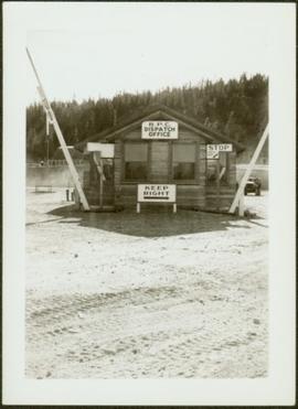
Photograph depicts wood building and signage, with traffic regulating beams raised on either side.
Handwritten annotation on verso reads: “Dawson Creek B.C. Bechtel Price Callahan Dispatch Office [1943]”
Photograph depicts wood building and signage, with traffic regulating beams raised on either side.
Handwritten annotation on verso reads: “Dawson Creek B.C. Bechtel Price Callahan Dispatch Office [1943]”
Photograph depicts large group of men gathered outside large building with the sign "WHITEHORSE GRILL".
Handwritten photo album caption below this photo reads: "Dawson Creek BC / 1943 Beer Ration Day".
Map depicts annotations marking the major freight-ways: Garnet Ent. Truck Haul from Vancouver to Terrace, Canada Freightways Lyndon Trucking from Vancouver-Edmonton-Alaska Highway, Lindsays Transfer from Terrace to Dease Lake and Telegraph Creek, and the Northland Navigation roll-on and roll-off service. The cities and towns of Vancouver, Prince George, Dawson Creek, Terrace, Kitimat and Whitehorse are noted.
Image depicts a road with a guardrail and open fields somewhere near Dawson Creek, B.C.
Image depicts a street of businesses in Dawson Creek, B.C.
Image depicts a large building which is labelled "Alberta Pool Elevators Ltd. Dawson Creek," located in Dawson Creek, B.C.
Image depicts the interior of what is possibly a heritage building in Dawson Creek, B.C.
Image depicts a street of businesses and Mile "0" of the Alaskan Highway in Dawson Creek, B.C.
Image depicts Mile "0" of the Alaskan Highway in Dawson Creek, B.C.
Image depicts the Station Museum in Dawson Creek, B.C.
Image depicts the interior of the Station Museum in Dawson Creek, B.C.
Image depicts stuffed wildlife exhibits inside the Station Museum in Dawson Creek, B.C.
Image depicts the Station Museum and the "Alberta Pool Elevators Ltd." building in Dawson Creek, B.C.
Image depicts an old barn located somewhere near Dunlevy Creek in the Dawson Creek area.
Image depicts the Dunlevy Creek area somewhere near Dawson Creek, B.C. The slide is simply labelled "Dunlevy irrigation" for uncertain reasons.
Image depicts an old barn located at a dairy farm somewhere near Dunlevy Creek in the Dawson Creek area.
Photographs within this file document natural and artificial features across the landscape of Northern British Columbia. This landscape also includes the physical, built, urban and industrial landscapes; topography; site plans; boundaries, districts, reserves, parks, sanctuaries, towns, villages and cities, etc.
Photographs within this file document Canadian military service, training activities, military institutions, bases and site; individuals and organizations (eg. veterans, military personnel, militia, cadets), military vehicles and ships, equipment, weapons, uniforms, artifacts and legislation as it pertains to Northern British Columbia.
File consists of trail maps and recreation guides from various places in British Columbia, especially Northern British Columbia. Maps include: