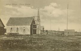
Prince George, BC

Elements area

Taxonomy

Code

Scope note(s)

    Source note(s)

      Display note(s)

        Hierarchical terms

        Prince George, BC

          Equivalent terms

          Prince George, BC

            Associated terms

            Prince George, BC

              321 Archival description results for Prince George, BC

              321 results directly related Exclude narrower terms
              2011.3.2.05 · Item · 1913
              Part of North Coast & Central BC Postcard Collection

              Lofty view of South Fort George, river and treed hills in the background. Printed annotation on verso reads: “South Fort George - 1913.” Handwritten message on recto is addressed to “Ethel M. Heurris Norton Maps Bristol County" reads: "11-1-13 an excellent view of south Fort George taken recently. Power Station at cross near water. This does not give all the south residence view. Population approx 1500”.

              View from Gunn Point
              2012.13.1.3.060 · Item · Nov. 1979
              Part of J. Kent Sedgwick fonds

              Image depicts a view of Prince George from Gunn Point in the L.C. Gunn Park looking north. Map coordinates 53°54'26.2"N 122°43'35.8"W.

              View from Gunn Point
              2012.13.1.3.061 · Item · Nov. 1979
              Part of J. Kent Sedgwick fonds

              Image depicts a view of Prince George from Gunn Point in the L.C. Gunn Park looking north. Map coordinates 53°54'26.2"N 122°43'35.8"W.

              View from Gunn Point
              2012.13.1.3.059 · Item · Nov. 1979
              Part of J. Kent Sedgwick fonds

              Image depicts a view of Prince George from Gunn Point in the L.C. Gunn Park looking north. Map coordinates 53°54'26.2"N 122°43'35.8"W.

              View from Gunn Point
              2012.13.1.3.064 · Item · Nov. 1979
              Part of J. Kent Sedgwick fonds

              Image depicts a view of Prince George from Gunn Point in the L.C. Gunn Park looking north. Map coordinates 53°54'26.2"N 122°43'35.8"W.

              View from Gunn Point
              2012.13.1.3.065 · Item · Nov. 1979
              Part of J. Kent Sedgwick fonds

              Image depicts a view of Prince George from Gunn Point in the L.C. Gunn Park looking north. Map coordinates 53°54'26.2"N 122°43'35.8"W.

              View from Gunn Point
              2012.13.1.3.058 · Item · Nov. 1979
              Part of J. Kent Sedgwick fonds

              Image depicts a view of Prince George from Gunn Point in the L.C. Gunn Park looking north. Map coordinates 53°54'26.2"N 122°43'35.8"W.

              View from Gunn Point
              2012.13.1.3.062 · Item · Nov. 1979
              Part of J. Kent Sedgwick fonds

              Image depicts a view of Prince George from Gunn Point in the L.C. Gunn Park looking north. Map coordinates 53°54'26.2"N 122°43'35.8"W.

              View from Gunn Point
              2012.13.1.3.063 · Item · Nov. 1979
              Part of J. Kent Sedgwick fonds

              Image depicts a view of Prince George from Gunn Point in the L.C. Gunn Park looking north. Map coordinates 53°54'26.2"N 122°43'35.8"W.

              View from Gunn Point
              2012.13.1.3.066 · Item · Nov. 1979
              Part of J. Kent Sedgwick fonds

              Image depicts a view of Prince George from Gunn Point in the L.C. Gunn Park looking north. Map coordinates 53°54'26.2"N 122°43'35.8"W.

              View from Gunn Point
              2012.13.1.3.067 · Item · Nov. 1979
              Part of J. Kent Sedgwick fonds

              Image depicts a view of Prince George from Gunn Point in the L.C. Gunn Park looking north. Map coordinates 53°54'26.2"N 122°43'35.8"W.

              Varves
              2012.13.1.124.16 · Item · Oct. 1975
              Part of J. Kent Sedgwick fonds

              Image depicts an example of varves, an annual layer of sediment or rock, with a pipe used for reference size. It is possibly located at the airport in Prince George, B.C.

              Varves
              2012.13.1.124.15 · Item · Oct. 1975
              Part of J. Kent Sedgwick fonds

              Image depicts an example of varves, an annual layer of sediment or rock, possibly located at the airport in Prince George, B.C.

              Van Bow Existing Zoning
              2023.5.1.12 · Item · Apr. 1977
              Part of UNBC School of Planning and Sustainability fonds

              Item is a hand drawn and coloured map by the City of Prince George Planning Department depicting existing zoning for the Van Bow neighbourhood area. Also includes two hand-drawn mylar overlays for the map; one showing "Opportunities & Constraints" such as housing age and condition and the other showing "Subdivision Activity" over decades of development in the Van Bow area.

              2023.5 · Fonds · 1976-2008

              Fonds consists of maps, plans, and drawings collected by faculty in the UNBC School of Planning and Sustainability. The majority of these maps reflect the planning history of the City of Prince George and include large format, hand-drawn plans created by the City Planning Department from the 1970s and 1980s. Maps from City of Prince George Official Community Plans are also included.

              Troll Lake Cabin
              2012.13.1.129.12 · Item · 1975
              Part of J. Kent Sedgwick fonds

              Image depicts numerous skiers at the cabin located at Troll Lake on Tabor Mountain in Prince George, B.C.

              2011.12.01 · Item · ca. 1950
              Part of Giscome, BC Historical Photograph collection

              Photo depicts a street perspective of Third Ave., in Prince George, BC, ca. 1950. Handwritten annotation in pen on verso of postcard reads: “You will undoubtedly notice that there are no tall buildings. I don’t think that there is one building in Prince George that is even five stories tall.”