Large-format map depicts Northwood Pulp & Timber operating areas in 1975.
Aleza Lake, BC
174 Archival description results for Aleza Lake, BC
Series consists of photographs created or accumulated by the Aleza Lake Research Forest Society.
File contains an original "Prince George Land and Resource Management Plan" published by the Government of British Columbia.
File contains an original "Proceeding of the Experimental Forests Workshop, April 28-29, 1992" co-published by the Government of Canada and the BC Ministry of Forests. Item is noted to be FRDA Report 202 and BCFRAC Report 2.
Reproduced map on mylar depicts a proposed railway spur for the Aleza Lake Forest Experiment Station.
Series consists of publications created by those associated with the Aleza Lake Research Forest as well as the Aleza Lake Research Forest Society itself. Includes various clippings and articles from serial publications such as newspapers and newsletters that focus on the ALRF. Also includes publications that served as reference material on topics relevant to the ALRF.
File consists of:
- Original version of Ralph Schmidt's 1993 BC Forest Service publication entitled "The Aleza Lake Experiment Station (1920's and 1930's)"
Slide depicts the Ranger Station at the Aleza Lake Experiment Station.
Slide depicts a burning building at the Aleza Lake Experiment Station on the date it was shut down by the BC Forest Service.
File consists of an original and a copy of a BC Forest Service pamphlet entitled "Reforestation in the Central Interior: A glimpse of the past and a view to the future". This pamphlet includes discussion of the Aleza Lake Experiment Station and John Revel's work.
File is a Resource Folio of maps and accompanying information created by Northwood Pulp & Timber regarding Timber Sale Harvesting Licence A01847, Willow River Block, Willow River P.S.Y.U. Includes maps that depict ungulates, waterfowl, recreation areas, special influence areas, and timber types. Most of the sheets have a duplicate, some with very slight variations. The following maps are supposed to be included in the but were missing upon arrival at the Archives: fish & topography, cutting permits & roads, and soils.
Slide depicts a sawmill in operation, likely located in the Upper Fraser area, with a pile of burning wood products and a beehive burner.
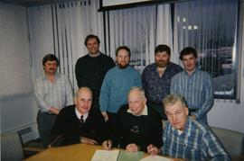
File consists of a photograph commemorating the signing of the first Aleza Lake Research Forest Management Plan. Front row, left to right: Ken Pendergast, BC Forest Service Prince George District Manager; Harry Coates, BCFS Forest Research Technician (1957-1993); John Revel, BCFS Silviculture Forester (1960-1993). Back row, left to right: Mike [?], BCFS Prince George Silviculture Manager; Henry Benskin, BCFS Research Branch; Michael Jull, BCFS Research Silviculturist, Prince George Region; Dan Lousier, BCFS Prince George Region Research Section Head; Brian Harding, Northwood Pulp & Timber Ltd. Woodlands Manager.
Map reproduction of the Sinclair Spruce Lumber Co. Ltd. T.S.H.L. A01848 C.P. 310 cutting area, likely in the Aleza Lake Research Forest.
Reproduced map on mylar depicts locations of elevations and benchmarks at the Aleza Lake forest.
File consists of slides depicting the Aleza Lake Research Forest and area taken by John Revel.
File consists of slides depicting the Aleza Lake Research Forest and area taken by Michael Jull.
File contains a photocopy of the BC Forest Service publication entitled "The Aleza Lake Research Forest: 'A Rich Past and a Bright Future' Provincial Colleges Tour" from June 1991.
File contains an original copy of a BC Forest Service publication entitled "The Development of the Spruce-Balsam Type in the Aleza Lake Experimental Forest" by A.R. Fraser and J.L. Alexander.
Slide depicts cleared ground and felled trees in a forested area, likely at the Aleza Lake Experiment Station.
File contains a photocopied version of "Tree Farm Licence No. 29 - Eagle Lake Sawmills Ltd. Cutting Permit Application No. 7". Although this item is not related to the Aleza Lake Research Forest, it is relevant to forest history in the Prince George area and therefore retained by the Society.
File consists of a booklet prepared for the May 9, 2002 UNBC/UBC Aleza Lake Research Forest Field Tour.
Slide depicts a view of what is possibly the Upper Fraser River.


