File consists of Harry Gairns' speaking notes for his 18 Sept. 2009 banquet talk at the "Exploring Our Roots: Forest History in Our Communities Annual Conference of the Forest History Association of BC" at UNBC in Prince George, September 19, 2009. Gairns' speech was entitled "Prince George Forest History - The 50s and the 60s".
Prince George, BC
192 Archival description results for Prince George, BC
File consists an audio recording of an oral history with Harry Coates recorded by David Mills.
Series consists of records created or accumulated by the Aleza Lake Research Forest Society regarding the research forest's history. Includes oral histories and material from long-time personnel that worked at the ALRF, such as Harry Coates, John Revel, and Frank Hellenius. Also contains copies of archival records from other archival institutions that concern the history of ALRF, which were compiled as part of a 2006/2007 history internship project.
Series consists of records reflecting the activities of the Dezell and Rustad families. Series include mayoral records from Bea and Garvin Dezell when Garvin served as Mayor of Prince George. Series includes materials celebrating Bea Dezell's life created by her family. Series also includes fundraising efforts for the Northern Medical Programs Trust. Finally, series includes a collection of "spruce" dollars and commemorative coins.
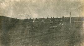
Photograph depicts Lheidli T'enneh Nation burial grounds in foreground, Hudson Bay Company buildings in background.
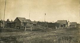
Photograph depicts a cluster of wooden buildings including a flagpole and church spire at a Lheidli T'enneh village site. Original photo identified this image as "Indian Village, Fort George".
File consists of a compilation of Experimental Projects in the Prince George Region. This compilation work was done by Stewart Taylor of the Ministry of Forests. Included are Experimental Projects regarding the Aleza Lake Research Forest that were selected from Taylor's larger project, which contained over 400 EP summaries for the Prince George Region.
File consists of a computer print-out of Ralph Schmidt and John Parminter's technical report entitled "An Early History of the Research Branch, British Columbia Ministry of Forests and Range".
Item is a BC Forest Service beverage coaster.
Videocassette is a VHS recording of an interview with John Revel produced by Spectrum Videoworks as part of a BC Forest Service "Esprit de Corps" institutional memory project.
Item consists of transcript and tape summary of interview with Elmer Nelson who discusses Axel Wenner- Gren's business interest in the Rocky Mountain Trench area of Northern British Columbia in the 1950s.
Harkins, BobFile consists an oral history with Michael Jull recorded by Barbara Coupe. Includes are transcripts and audio recordings.
File consists an oral history with John Revel recorded by Barbara Coupe. Includes are transcripts and audio recordings.
Image depicts the Northwood Pulpmill in Prince George, B.C. taken from above the Nechako River looking east. Map coordinates 53°56'00.0"N 122°44'29.7"W
Image depicts Prince George Sawmill taken from across the Nechako River looking southwest. Map coordinates 53°56'00.0"N 122°44'29.7"W
Image depicts Prince George Sawmill taken from across the Nechako River looking southwest. Map coordinates 53°56'00.0"N 122°44'29.7"W
Series consists of 7 mini DVs recording "Exploring Our Roots: Forest History in Our Communities Annual Conference of the Forest History Association of BC" at UNBC in Prince George, September 18-19, 2009. Harry Gairns and Mike Apsey spoke and conference panel topics include:
- Looking to the Past to Inform the Future? Forest History within a Contemporary Context
- Applying Traditional Knowledge to Future Initiatives: First Nations Historical and Future Relationships with the Forests
- Forestry History in Our Communities: Robson Valley & Prince George
- Exploring Our Roots: Forest History Research Methodology
- From Exploration to Development: Bringing Forest History Forward.
File consists an oral history with Harry Coates recorded by Barbara Coupe. Includes a transcript and audio recording.
File consists an oral history with Harry Coates recorded by David Mills. Includes a transcript and audio recording.
A VHS tape containing "The Mark of Progress" film created by the British Columbia Forest Service and first played for a live audience in 1959 in Prince George, BC.
File consists of two videos:
- A VHS video tape containing "Mark of Progress" promotional and possible training video for the BC forest industry in and around Prince George
- A VHS tape "Reforestation in British Columbia: A Growing Success" published by the Province of British Columbia Ministry of Forests.
File consists of:
- David Mills, "Aleza Lake Research Forest Historical Internship Summary" (2 Jan. 2007), 26 p. - In print and original digital .doc file
- David Mills, "Aleza Lake Forest Experiment Station Socio-Economic Time Line 1905-1937" (2007), 68 p. - In print and original digital .doc file
- ALRFS employment paperwork for David Mills, the ALRFS Natural Resource History Intern
- Research notes, including a copy of a map of the town of Aleza Lake in the 1920s
File consists of:
- Original version of Ralph Schmidt's 1993 BC Forest Service publication entitled "The Aleza Lake Experiment Station (1920's and 1930's)"
File consists of one VHS tape showing the building of the Northwood Pulp Mill in Prince George. Video has no sound.
Item is McNaughton Lake, B.C. Map 83D and Part of 83C Second Status Edition (1975) from "Classification and Interpretation of some Ecosystems of the Rocky Mountain Trench, Prince George Forest Region, British Columbia: First Approximation" (1984).
File consists of trail maps and recreation guides from various places in British Columbia, especially Northern British Columbia. Maps include:
- British Columbia Road Map and Parks Guide
- Northwood Pulp and Timber Limited Forest Operations Recreation Map
- Provincial Parks of Northern British Columbia
- Visitor's Guide: Mackenzie Woodlands
- Visitors Guide: Mackenzie Woodlands
- Mackenzie Forest District Recreation Map
- Dawson Creek Forest District Recreation Map
- Morice Forest District Recreation Map
- Fort St. James Forest District Recreation Map
- Lakes Forest District Recreation Map
- Cariboo Forest Region Recreation Map
- Lakes District Visitors Map
- Prince George Forest District Recreation Map
- Vanderhoof Forest District Recreation Map
- Fort St. John Forest District Recreation Map
- Cariboo Forest Region Recreation Map (East)
- Robson Valley Forest District Recreation Map
- Fort Nelson Forest District Recreation Map
- Forest Service Recreation Sites: Valemount - Blue River
- Forest Service Recreation Sites: McBride - Goat River
- Forest Service Recreation Sites: Prince George West
- Forest Service Recreation Sites: Moberly - Sukunka
- Forest Service Recreation Sites: Nation - Takla
- Forest Service Recreation Sites: Murrat - Kiskatinaw
- Recreation Road Map for the Prince George Forest Area (1987-1988)
- Recreation Road Map for the Prince George Forest Area (1997)
- The Bobtail Forest Service Road Tour
- Forest Recreation Map: Northwood Pulp and Timber Limited
- Forest Operations Recreation Map: Northwood pulp and timber limited
- Forest Service: Recreation Sites Williston/Mackenzie
- Forest Service Recreation Sites Prince George West
- The Official Prince George Tourist Street Map
- Ecological Reserves in British Columbia (July 1990)
- Prince George Forest District map (April 1990) with annotations regarding trials.
File consists of recreational guides from various places in British Columbia, especially Northern British Columbia. Guides include:
- The North Ridge Ecr-Trail Guide: Aleza Lake Research Forest
- Cluculz Lake Silviculture Demonstration Area: Trail Guide
- Willow River Interpretive Trail
- Crooked River Forest Self-Guided Circle Tour
- Forests for the World Interpretive Trail Guide
- Cottonwood Island Nature Park: Habitat Enhancement.
The Aleza Lake Research Forest Society (ALRFS) records encompass material that was created or collected by the Society over its existence (2001-present). Records created by the ALRFS consist of administrative and operational records, as well as publications from the Society. Collected records include historical records relating to the Aleza Lake Experiment Forest gifted to the Society or its members. These include maps, photographs, reference material, and documents. Members and associates of the ALRFS also documented the history of the forest through the creation of oral history recordings and written histories such as John Revel's "Devil's Club, Black Flies, and Snowshoes".
The fonds includes a significant amount of reproduced archival material about Aleza Lake from other institutions, such as BC Archives, the Canadian Forest Service, and the BC Forest Service. Many of these reproductions were created as part of the 2006 ALRFS Natural Resources History Internship in an effort to compile the history of the research forest.
Also included are cartographic and photographic materials that depict the Aleza Lake Research Forest and surrounding areas.
File consists of a booklet prepared for the May 9, 2002 UNBC/UBC Aleza Lake Research Forest Field Tour.
Photographs are panoramas taken from the Churchill BC Forest Service Lookout, located at latitude 54°04' and longitude 122°16'. The photographs were bound together and include a transparent grid that was intended to be used for locating forest fires.
Photograph depicts Harry Coates, Ted Baker, and John Revel at Aleza Lake Research Forest re-opening ceremony on July 9, 1992.
Aerial photograph depicts a view overlooking the Georges farm. Note on back stated that this photograph was presented in a frame to the Georges in 2008.
Slide depicts a bulldozer clearing ground, likely at the Aleza Lake Experiment Station.
Slide depicts cleared ground and felled trees in a forested area, likely at the Aleza Lake Experiment Station.
Slide depicts the Ranger Station at the Aleza Lake Experiment Station.
Slide depicts a view of what is possibly the Upper Fraser River.
Slide depicts a cleared area at the Aleza Lake Experiment Station with plant regeneration.
Slide depicts a burning building at the Aleza Lake Experiment Station on the date it was shut down by the BC Forest Service.
Slide depicts a cleared area in a forest, likely at the Aleza Lake Experiment Station.
Slide depicts a detonation in an area of cleared ground in a forested area, likely the Aleza Lake Experiment Station. Work may have been undertaken for roadbuilding activities at the Experiment Station.
Slide depicts the original wooden BC Forest Service sign for the Aleza Lake Forest Experiment Station.
Slide depicts a black bear eating garbage by wooden outbuildings, possibly at the Aleza Lake Experiment Station.
Slide depicts a sawmill in operation, likely located in the Upper Fraser area, with a pile of burning wood products and a beehive burner.
Slide depicts a heavily forested area with fallen logs, likely at the Aleza Lake Experiment Station.
Slide depicts a man operating heavy equipment in a forest, likely at the Aleza Lake Experiment Station.
Large-format map depicts the Monkman Public Sustained Yield Unit (PSYU) and Tree Farm Licence 30 east of Prince George.
Large-format map depicts Northwood Pulp & Timber operating areas in 1975.
Large-format map depicts the Monkman Public Sustained Yield Unit (PSYU) east of Prince George.
File consists of an audio recording of an interview with Bill Wade. Includes one original recorded audio cassette and one copy.
File consists of an audio recording of an interview with Ray Williston. Includes three original recorded audio cassettes and three copies.


