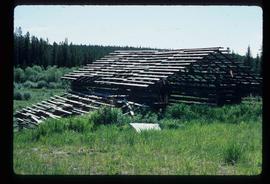
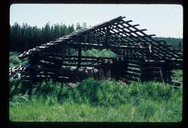
Prince George, BC

Elements area

Taxonomy

Code

Scope note(s)

    Source note(s)

      Display note(s)

        Hierarchical terms

        Prince George, BC

          Equivalent terms

          Prince George, BC

            Associated terms

            Prince George, BC

              485 Archival description results for Prince George, BC

              485 results directly related Exclude narrower terms
              2012.13.1.3.110 · Item · 12 Oct. 1989
              Part of J. Kent Sedgwick fonds

              Image depicts George St in downtown Prince George with City Hall in the background. Also visible are the Prince George Hotel, Ming's Inn Chinese Restaurant, Fraser Stationers Ltd., Weiner King food cart, and a movie theatre. Map coordinates 53°54'55.0"N 122°44'36.1"W

              Pine Centre Mall
              2012.13.1.3.111 · Item · 12 Oct. 1989
              Part of J. Kent Sedgwick fonds

              Image depicts Pine Centre Mall in Prince George, B. C. Map coordinates 53°53'53.2"N 122°46'36.4"W

              Yellowhead Bridge
              2012.13.1.3.120 · Item · 12 Oct. 1989
              Part of J. Kent Sedgwick fonds

              Image depicts the Yellowhead Bridge across the Fraser River. Map coordinates 53°54'45.2"N 122°43'27.9"W

              Mr. P.G.
              2012.13.1.3.122 · Item · 12 Oct. 1989
              Part of J. Kent Sedgwick fonds

              Image depicts Mr. P.G. and the Tourism Information site at the intersection of Highway 16 and 97. Map coordinates 53°53'46.5"N 122°46'00.7"W

              Prince George
              2012.13.1.3.135 · Item · 12 Oct. 1989
              Part of J. Kent Sedgwick fonds

              Image depicts Prince George, possibly with the Northwood Pulpmill in the background.

              Salvation Army
              2012.13.1.3.112 · Item · 12 Oct. 1989
              Part of J. Kent Sedgwick fonds

              Image depicts the Salvation Army on Ospika Boulevard in Prince George, B.C. Map coordinates 53°55'02.6"N 122°47'41.6"W.

              Central Street West
              2012.13.1.3.115 · Item · 12 Oct. 1989
              Part of J. Kent Sedgwick fonds

              Image depicts Central Street West, parallel to Highway 97 in Prince George, B.C. looking north. Shown: Prince George Motors and other car dealerships, Burger King, Grama's Inn, and the Spruceland Shopping Mall sign. Map coordinates 53°54'42.1"N 122°46'53.1"W

              Foothills Bridge
              2012.13.1.3.123 · Item · 12 Oct. 1989
              Part of J. Kent Sedgwick fonds

              Image depicts the Foothills Bridge over the Nechako river on the Foothills Boulevard in Prince George, B.C. Map coordinates 53°56'52.5"N 122°48'59.9"W

              Prince George
              2012.13.1.3.133 · Item · 12 Oct. 1989
              Part of J. Kent Sedgwick fonds

              Image depicts Prince George, possibly with the Northwood Pulpmill in the background.

              Beehive Burner
              2012.13.1.3.088 · Item · 12 Oct. 1989
              Part of J. Kent Sedgwick fonds

              Image depicts a Beehive Burner along the Nechako on River Road. Map coordinates 53°55'34.1"N 122°44'58.0"W

              Salvation Army
              2012.13.1.3.114 · Item · 12 Oct. 1989
              Part of J. Kent Sedgwick fonds

              Image depicts the Salvation Army on Ospika Boulevard in Prince George, B.C. Map coordinates 53°55'02.6"N 122°47'41.6"W

              Lakeland Sawmill
              2012.13.1.3.130 · Item · 12 Oct. 1989
              Part of J. Kent Sedgwick fonds

              Image depicts the Lakeland Sawmill in Prince George, B.C, identified by the beehive burners; the one with white smoke belonged to Pas Lumber Co. which was bought out by Lakeland in 1987.

              Beehive Burner
              2012.13.1.3.089 · Item · 12 Oct. 1989
              Part of J. Kent Sedgwick fonds

              Image depicts a Beehive Burner along the Nechako on River Road. Map coordinates 53°55'34.1"N 122°44'58.0"W.

              2012.13.1.3.108 · Item · 12 Oct. 1989
              Part of J. Kent Sedgwick fonds

              Image depicts 4th Ave at Quebec St, showing the following businesses: The Yarn Barn, Golden Chalice Jewellers, Dandy Lines, Ultrasport, and Saveco. Map coordinates 53°54'58.6"N 122°44'47.5"W

              CN Train Yard
              2012.13.1.3.121 · Item · 12 Oct. 1989
              Part of J. Kent Sedgwick fonds

              Image depicts a number of trains in the CNR train yard taken from River Road in Prince George, B.C. Map coordinates 53°54'51.5"N 122°43'29.6"W

              Prince George
              2012.13.1.3.134 · Item · 12 Oct. 1989
              Part of J. Kent Sedgwick fonds

              Image depicts Prince George, possibly with the Northwood Pulpmill in the background.