Prince George, BC
2245 Archival description results for Prince George, BC
2245 results directly related
Exclude narrower terms
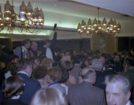
2009.6.13.49.1176
·
Item
·
[Feb. 1978?]
Part of The Honourable Iona Campagnolo fonds
Photograph depicts a photographer and other men standing over a crowd at Northern BC Winter Games event in Prince George.
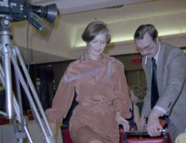
2009.6.13.49.1177
·
Item
·
[Feb. 1978?]
Part of The Honourable Iona Campagnolo fonds
Photograph depicts Iona Campagnolo being directed to her seat by a man with a cigarette at a Northern BC Winter Games event in Prince George.

2012.13.1.3.046
·
Item
·
Jan. 1978
Part of J. Kent Sedgwick fonds
Image depicts a view of Prince George from City Hall looking northeast along George Street. Map coordinates 53°54'46.3"N 122°44'41.9"W

2012.13.1.3.047
·
Item
·
Jan. 1978
Part of J. Kent Sedgwick fonds
Image depicts a view of Prince George from City Hall looking north. Map coordinates 53°54'46.3"N 122°44'41.9"W

2012.13.1.3.049
·
Item
·
Apr. 1978
Part of J. Kent Sedgwick fonds
Image depicts a view of Prince George from Cranbrook Hill looking southeast. Map coordinates 53°54'51.5"N 122°49'05.2"W

2012.13.1.3.050
·
Item
·
Apr. 1978
Part of J. Kent Sedgwick fonds
Image depicts a view of Prince George from Cranbrook Hill looking east. Map coordinates 53°54'51.5"N 122°49'05.2"W

2012.13.1.3.051
·
Item
·
Apr. 1978
Part of J. Kent Sedgwick fonds
Image depicts a view of Prince George from Cranbrook Hill looking southeast. Map coordinates 53°54'51.5"N 122°49'05.2"W

2012.13.1.3.053
·
Item
·
Apr. 1978
Part of J. Kent Sedgwick fonds
Image depicts a view of Prince George from Cranbrook Hill looking east with pulpmill and downtown in background.
2012.13.2.07
·
Subseries
·
1978-2008
Part of J. Kent Sedgwick fonds
Subseries consists of material collected and created by Kent Sedgwick for research relating to agriculture in Prince George and the surrounding areas including Pineview, Mud River, and Blackburn. Includes material regarding the Prince George experimental farm, historical agriculture, dairying, and ranching.

2012.13.1.3.048
·
Item
·
Apr. 1978
Part of J. Kent Sedgwick fonds
Image depicts a view of Prince George from Cranbrook Hill looking east. Map coordinates 53°54'51.5"N 122°49'05.2"W
2002.12.2.2
·
Item
·
1978
Part of Bob Harkins fonds
Item consists of transcript of interview with Prince George Librarian John Backhouse regarding the referendum for the proposed construction of a new city library.
Backhouse, John
2002.12.2.1
·
Item
·
1978
Part of Bob Harkins fonds
Item consists of transcript of interview with librarian John Backhouse conducted by Bob Harkins at Prince George Radio Station, CJCI regarding an upcoming referendum in Prince George for the proposed land settlement fund use to build a new library in Prince George.
Harkins, Bob
2006.9.25
·
File
·
1978
Part of Bob Harkins fonds
File consists of 1 audiocassette of interviews by Bob Harkins with John Backhouse, city librarian discussion of referendum on construction of new library. Also contains interview with Don Thatcher, conservation officer.
2009.6.1.344
·
Item
·
1978
Part of The Honourable Iona Campagnolo fonds
Long building in background.
Handwritten annotation on verso reads: “with Pierre T + Rob B at P. George, winter 78”.
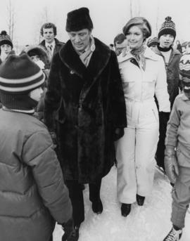
2009.6.1.346
·
Item
·
1978
Part of The Honourable Iona Campagnolo fonds
Handwritten annotation on verso reads: “Northern BC Winter Games ’77 Prince George”.
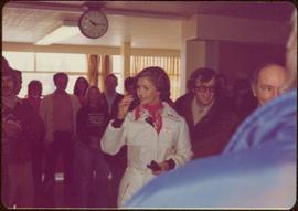
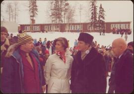
2009.6.13.49.0451
·
Item
·
February 1978
Part of The Honourable Iona Campagnolo fonds
Photograph depicts Iona Campagnolo, Pierre Trudeau and Ron Basford talk with an unidentified crowd of children and adults at a children's speed skating event during the 1978 Northern BC Winter Games.
2009.6.13.49.1175
·
Item
·
[Feb. 1978?]
Part of The Honourable Iona Campagnolo fonds
Photograph depicts Prime Minister Pierre Trudeau, Evelyn Basso, and a man standing in a crowd at a Northern BC Winter Games event in Prince George.

2012.13.1.3.052
·
Item
·
Apr. 1978
Part of J. Kent Sedgwick fonds
Image depicts a view of Prince George from Cranbrook Hill looking east.
2012.13.1.123
·
Subseries
·
[between 1978 and 1979]
Part of J. Kent Sedgwick fonds
File contains slides depicting maps for land use in Prince George.
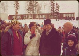
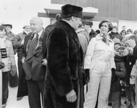
2009.6.13.49.0449
·
Item
·
February 1978
Part of The Honourable Iona Campagnolo fonds
Photograph depicts Iona Campagnolo standing on ice with Pierre Trudeau at a children's speed skating event during the 1978 Northern BC winter games. Several unidentified children and adults surround them.
2009.6.13.49.0450
·
Item
·
February 1978
Part of The Honourable Iona Campagnolo fonds
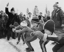
Photograph depicts Pierre Trudeau firing a starting pistol at a children's speed skating event during the 1978 Northern BC Winter Games. Iona Campagnolo, Ron Bassford and an unidentified crowd watch four children crouch at the starting line.
2009.6.13.49.0452
·
Item
·
February 1978
Part of The Honourable Iona Campagnolo fonds
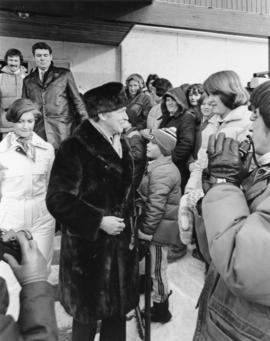
Photograph depicts Pierre Trudeau talking with a crowd of children and adults at a children's speed skating event during the 1978 Northern BC Winter Games. Iona Campagnolo stands behind Pierre Trudeau, looking downward. Two photographers are in the foreground.

2009.6.13.49.0453
·
Item
·
February 1978
Part of The Honourable Iona Campagnolo fonds
Photograph depicts Pierre Trudeau talking with a four unidentified children at a children's speed skating event during the 1978 Northern BC Winter Games. Iona Campagnolo stands behind Pierre Trudeau. An unidentified man is in the foreground. Several unidentified adults are in the background.
2009.6.13.49.1174
·
Item
·
[Feb. 1978?]
Part of The Honourable Iona Campagnolo fonds
Photograph depicts Prime Minister Pierre Trudeau and three women in a crowd at a Northern BC Winter Games event in Prince George.

2012.13.1.3.045
·
Item
·
Jan. 1978
Part of J. Kent Sedgwick fonds
Image depicts a view of Prince George from City Hall looking northeast with the pulp mills in the background. Map coordinates 53°54'46.3"N 122°44'41.9"W

2012.13.1.3.054
·
Item
·
Apr. 1978
Part of J. Kent Sedgwick fonds
Image depicts a view of Prince George from Cranbrook Hill looking southeast. Map coordinates 53°54'51.5"N 122°49'05.2"W
2012.13.2.01.03.1
·
Item
·
[after 1978]
Part of J. Kent Sedgwick fonds
Map depicts the city of Prince George Boundary expansions since incorporation in 1915.

2012.13.1.122.12
·
Item
·
1977
Part of J. Kent Sedgwick fonds
Image depicts a logging area somewhere near Prince George, B.C.

2012.13.1.3.037
·
Item
·
Nov. 1977
Part of J. Kent Sedgwick fonds
Image depicts power lines east of the pulp mills in Prince George, B.C.

2012.13.1.3.040
·
Item
·
Nov. 1977
Part of J. Kent Sedgwick fonds
Image depicts the flows from a pulp mill in Prince George, B.C.

2012.13.1.3.041
·
Item
·
Nov. 1977
Part of J. Kent Sedgwick fonds
Image depicts an esker at the Foothills Boulevard in Prince George, B.C.

2012.13.1.3.043
·
Item
·
Nov. 1977
Part of J. Kent Sedgwick fonds
Image depicts an area undergoing logging somewhere in Prince George, B.C.

2012.13.1.6.084
·
Item
·
July 1977
Part of J. Kent Sedgwick fonds
Image depicts Mud River, also known as the Chilako River, at Blackwater Road, Prince George, B.C.
2006.9.11
·
File
·
c.1977
Part of Bob Harkins fonds
File consists of 1 audiocassette of people interviewed by Bob Harkins. Side A consists of interviews with Bill Jones of the Fort George Railway Society, Walter Gill formerly of the BC Provincial Police, and Bob Sebastian, of the Carrier First Nation. Side B consists of interviews with Ella Fry, a trapper from Valemount and Prince George boxer Harold Mann.
2012.13.2.01.03.4
·
Item
·
Mar. 1977
Part of J. Kent Sedgwick fonds
Map depicts boundaries of study areas, including major study area, community study area, and the city of Prince George boundaries.

2012.13.1.3.036
·
Item
·
Nov. 1977
Part of J. Kent Sedgwick fonds
Image depicts an agricultural field, most likely near Prince George, B.C.

2023.5.1.11
·
Item
·
22 Apr. 1977
Part of UNBC School of Planning and Sustainability fonds
Item is a hand drawn and coloured map by the City of Prince George Planning Department depicting existing land use for the Van Bow neighbourhood area.

2023.5.1.12
·
Item
·
Apr. 1977
Part of UNBC School of Planning and Sustainability fonds
Item is a hand drawn and coloured map by the City of Prince George Planning Department depicting existing zoning for the Van Bow neighbourhood area. Also includes two hand-drawn mylar overlays for the map; one showing "Opportunities & Constraints" such as housing age and condition and the other showing "Subdivision Activity" over decades of development in the Van Bow area.

2023.5.1.13
·
Item
·
Aug. 1977
Part of UNBC School of Planning and Sustainability fonds
Item is a map annotated in colour by the City of Prince George Planning Department depicting major residential development proposals from June 1975 to August 1977 in the City of Prince George. This map was drawn for the City of Prince George interim Community Plan.

2012.13.1.3.044
·
Item
·
Nov. 1977
Part of J. Kent Sedgwick fonds
Image depicts the Tabor Lake Subdivision in Prince George, B.C.

2012.13.1.122.13
·
Item
·
1977
Part of J. Kent Sedgwick fonds
Image depicts a logging area somewhere near Prince George, B.C.

2012.13.1.124.25
·
Item
·
1977
Part of J. Kent Sedgwick fonds
Image depicts layers of silt along the Chilako River near Blackwater Road, Prince George, B.C.
2009.6.1.151
·
Item
·
[ca. 1977]
Part of The Honourable Iona Campagnolo fonds
Photograph taken inside unidentified building, camera visible in left foreground.
Handwritten annotation on verso reads: “Prince George”.

2012.13.1.3.038
·
Item
·
Nov. 1977
Part of J. Kent Sedgwick fonds
Image depicts natural meadows, possibly east of Prince Georg, B.C.

2012.13.1.3.042
·
Item
·
Nov. 1977
Part of J. Kent Sedgwick fonds
Image depicts downtown Prince George looking northwest across Dominion Street. Map coordinates 53°54'48.7"N 122°44'45.6"W

2012.13.1.124.23
·
Item
·
March 1976
Part of J. Kent Sedgwick fonds
Image depicts grooving on Tabor Mountain in Prince George, B.C.

2012.13.1.124.24
·
Item
·
[1976?]
Part of J. Kent Sedgwick fonds
Image depicts grooves on Tabor Mountain in Prince George, B.C.

2012.13.1.3.034
·
Item
·
Mar. 1976
Part of J. Kent Sedgwick fonds
Image depicts a view of Prince George from Carney Hill.

2012.13.1.3.035
·
Item
·
Oct. 1976
Part of J. Kent Sedgwick fonds
Image depicts a nature trail along the Nechako River at Island Cache looking west with the cutbanks in the background. Map coordinates 53°55'36.2"N 122°45'11.8"W