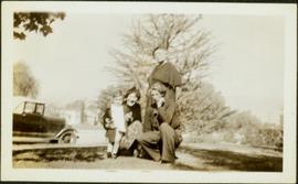
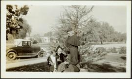
Image depicts the Upper Fraser Road running through Upper Fraser, B.C. A beehive burner is seen in the background on the left and the mill office is seen on the right. Map coordinates 54°07'05.7"N 121°56'38.9"W
Elements area
Taxonomy
Code
Scope note(s)
Act of means of transporting from one place to another
Act of means of providing water, power, sewage, etc. to communities
Facilities and infrastructures (eg. harbours, highways, airports, hydroelectric projects)
Vehicles, rolling stock, aircraft, equipment, ships and boats, ferries
Accidents (eg. highway crashes, derailments, air crashes, ship wrecks)
Rescue services (eg. towing, coast guard)
Businesses and corporations (eg. motor associations)
Professional organizations and unions
SEE ALSO: Agriculture; Business and Commerce; Industries; Military
Source note(s)
MemoryBC Subject Groups