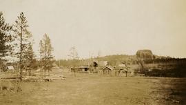
Photograph depicts a view of Lone Butte, BC. The butte formation of the same name (Lone Butte) is visible in the background; a ranch or residence is visible in the foreground. Wyness notes that Lone Butte was the "last one [they] tied in". "Tying in" is a land surveying technique. Since the photograph is dated October 1936 and Wyness described the survey trip as lasting June 5 - October 8, 1936, that implies that Lone Butte was the last location they surveyed on this trip.
Elements area
Taxonomy
Code
Scope note(s)
Claiming, settling, and moving to a new land
Land titles, distribution, grants, etc.
Community and regional settlement patterns
Land settlement companies
Land surveys and surveyors
Real estate companies and activities
Organizations involved in sponsoring and supporting immigrants
Source note(s)
MemoryBC Subject Groups
