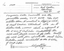
File consists of two letters written by John McCormick to a friend describing his experiences in Barkerville and the gold mining conditions on Williams Creek.
Zonder titelPhotographs within this file document natural and artificial features across the landscape of Northern British Columbia. This landscape also includes the physical, built, urban and industrial landscapes; topography; site plans; boundaries, districts, reserves, parks, sanctuaries, towns, villages and cities, etc.
Photographs within this file document stern wheelers operating in Northern BC from ca. 1901 - 1915.
Consists of a photograph album that contains 224 photographs that depict Parker Bonney's early years as a Forest Engineer. Includes photographs of the expedition to the Nass Valley undertaken by Parker Bonney, Sam Brown, and others. May also include photographs of later surveying expeditions. Also includes three photographs of the University of Washington rowing team, of which Parker Bonney was a member between 1909 and 1913.
Consists of a photograph album that contains photographs that depict Parker Bonney's early years as a Forest Engineer. Includes photographs of the expedition to the Nass Valley undertaken by Parker Bonney, Sam Brown, and others. May also include photographs of later surveying expeditions.
File consists of a bound typescript book titled "Land Settlement (A report by a C.S.T.A Committee)" produced by the Canadian Society of Technical Agriculturists in 1941.
File consists of a report titled "A Study of Land Settlement in the Prince George-Smithers area, British Columbia" by W.J. Anderson and published by the authority of the Right Hon. James G. Gardiner, Minister of Agriculture in Ottawa, Canada (Oct. 1947).
File consists of a 1953 North Peace High School yearbook.
File consists of a preliminary study undertaken by the Lower Mainland Regional Planning Board of B.C. examining the growing metropolitan populaton of Greater Vancouver. Includes a report on the findings in member municipalites.
File consists of a 1955 North Peace High School yearbook.
File consists of G. Gary Runka's high school records.
File consists of two Peace River District High School Curling Championship patches.
File consists of a brief developed by the Lower Mainland Regional Planning Board of B.C. examining the problems with expanding urban sprawl in Greater Vancouver, outlining the findings of the research, and offering future suggestions.
File consists of notes relating to Buckhorn Elementary School. Also includes photographs depicting the old Buckhorn School building and the Prince George Snowmobile club building from the exterior (between 2001 and 2005).
File consists of a 1957 North Peace High School yearbook.
File consists of a report by the Lower Mainland Regional Planning Board of B.C. outlining a continued program of housing research for the Greater Vancouver Area. The report examines similar experiences of other urban cities and outlines the proposed program for housing analysis.
File consists of information gathered on Gerald (Gerry) Smedley Andrews, Surveyor General of the Province of British Columbia and Director of Mapping and Provincial Boundaries Commissioner. File contains greeting cards, correspondence, articles written by both Audrey L'Heureux and Gerry Andrews, a booklet on land surveying, and reproductions from the G. Smedley Andrews collection at BC Archives. Correspondence includes letters to and from L'Heureux and her publisher Northern B.C. Book Publishing as well as letters between L'Heureux and Gerry Andrews. Highlights include:
- Reproduction of G.S. Andrews' article "Surveys and Mapping in British Columbia Resources Development", 1954 (article)
- G.S. Andrews, "The Land Surveying Profession in British Columbia", 1955 (booklet)
- Reproduction of article by Gerry Andrews in The Victoria Naturalist 46 (3) entitled "My Bear", 1989 (article)
- G. Smedley Andrews, "Metis Outpost", 1985 (promotional pamphlet)
- Reproduction of paper by G. Smedley Andrews entitled "The Makings of a Surveyor General", 1989 (document)
- Dave Robinson and Mike Hocking, "The Monkman Pass and Trail: A Brief History", 1982 (book)
- G.S. Andrews, "Professional Land Surveyors of British Columbia: Cumulative Nominal Roll, 4th Edition", 1978 (booklet).
File also includes a photograph reprint of "Trout Lake Johnny" from the collection of the uncle of G.S. Andrews.
File consists of material relating to William John "Wiggs" O'Neill, a riverboat pioneer. Wiggs began working on a Skeena River sternwheeler in 1898 and continued working on the river until the end of the steamboat era in 1911. He then moved to Smithers, where he operated the first power plant and owned an auto agency for 43 years. Materials include two books, newspaper clippings, and reproductions of journal articles. Highlights include:
- Wiggs O'Neill, "Steamboat Days on the Skeena River British Columbia", 1963 (book)
- Wiggs O'Neill, "Whitewater Man of the Skeena", 1960 (book)
File consists of G. Gary Runka's UBC academic records.
File consists of a report undertaken by the Lower Mainland Planning Board of B.C. forecasting the future of industrial land prospects. This report is part of a larger study of industrial settlement in the province.
File consists of a study examining the residential land structure of Metropolitan Vancouver. This study is supplementary to the Land for Living study. Includes one report of the findings and analysis of the study.
File consists of annual district reports from 1969 and 1971 for the BC Department of Agriculture Development and Extension Branch detailing weather, crops, and season highlights. Includes a booklet on soil capability classifications and Central BC and Caribou agricultural census data for 1961-1966.
File consists of a report by the Lower Mainland Regional Planning Board of B.C. regarding the needs of industrial land. The report describes methods for carrying out these needs with suitable sites in the Lower Mainland area.
File consists of population data from the Regional District of Fraser-Fort George.
File consists of a report by the Lower Mainland Regional Planning Board of B.C. on the future industrial land prospects of the Lower Mainland.
File consists of a report by the Lower Mainland Regional Plannng Board of BC concerning availible farming land in the Lower Mainland.
File consists of a report by the Lower Mainland Regional Planning Board of B.C. regarding the facilities that serve households and standards of lower mainland dwelling facilities. The study correlates with a larger "Land for Living" report about land development in the Lower Mainland.
File consists of a report by the Lower Mainland Regional Plannng Board of BC concerning availible land in the Lower Mainland.
File consists of a study by the Lower Mainland Regional Planning Board of B.C. regarding the attitudes of residents in the Greater Vancouver fringe areas toward their environment. The study was part of the larger "Land for Living" report about land development in the Lower Mainland. Includes Part 1 and Part 2 of the report detailing survey structure, findings, and interpretation.
File consists of assorted maps, correspondence, and speeches examining the prospects of park establishment in the Prince George area.
File consists of a petition by the Union of British Columbia Municipalities against the Amchitka Nuclear Test by the Atomic Energy Commission of the United States of America.
File consists of a study by the Associated Engineering Services Ltd. on the metropolitan traffic of Prince George.
File consists of Gary Runka's business and identification cards.
File consists of G. Gary Runka's Cornell University academic records.
File consists of academic papers written by Gary Runka during his 1966-1967 Master of Science in Natural Resource Management and Land Use Planning at Cornell University, New York.
File consists of a bylaw for the City of Prince George to establish zoning. Includes a regional index of the Prince George area.
File consists of a plan to develop Pigeon Lake as a provincial park.
File consists of papers written by G. Gary Runka during his role as BC Land Inventory Field Coordinator. Selected works include:
- "Comments on General Soil Characteristics related to B.C. Industrial Zoning Maps",
- "Ektachrome Infra-red and Ektachrome Aerial Photography Project - Pitt Meadows",
- "A Short Course on Mapping Forest Lands Sept. 21-23, 1972, Prince George, Glacial Landforms and Surficial Materials",
- "Soil Stability Ratings - South Okanagan", "East Kootenay Soil Capability for Agriculture - Agriculture Sector Review - Report to B.C. Intersector Evaluation Committee",
- "Bulkley Intersector Analysis Area - Section I: Agriculture Sector Report - Report to B.C. Intersector Analysis Committee",
- "Dryland and Irrigated Agriculture Capability Ratings - Sept. 1, 1971",
- "Report on Land Capability for Agriculture and Forestry Prince George - Quesnel, Special Sale Area, B.C.",
- "East Kootenay (Region 13) Soil Capability for Agriculture and the Intersector Evaluation",
- "Tentative Correlation of Soils of British Columbia with Climatic Criteria", and,
- "Urban Suitability vs Resource Conservation an Interpretation of British Columbia Land Inventory Data, 14 May, 1973".
File consists of multiple documents concerning the development of a master plan for the Regional District of Fraser-Fort George.
File consists of an appraisal by the Lower Mainland Regional Planning Board of the labour force and employment in Vancouver. This report is supplementary to other similar studies examining changes in the labour force.
File consists of recreation reports, a Knothole zoning by-law article, public hearing agenda, and an industrial land use report, a number of reports on the zoning needs of small surrounding communities, a report on proposed rail routes to the NE of the province, a report on space requirements for downtown Prince George, a proposed study of water supply and sewage requirements in Prince George, a community analysis, statistics and information, presentation speeches on the tourism industry, and a report on the Hospital District in Fraser-Fort George.
File consists of the preliminary outline of an urban pattern study by N. Pearson. Appended to the beginning of the report, members of the technical committee have laid out points of constructive critisicm about the drafted report. Includes a few pages of suggested edits and a drafted report on urban patterns.
File consists of a paper by the Lower Mainland Regional Planning Board of B.C. about the purchasing power of consumers in the Lower Mainland. The paper examines how rising income might affect urban living and possible responses.
File consists of prospective planning material for the Regional District of Fraser Fort-George. Includes a recreation and tourism booklet, standardization of building code, technical planning committee documents, questionnaires, a community plan, a public lot draw document, and a study to increase secondary industry in the region.
File consists of a draft copy of an address by J.D. Mawell for delivery at the Sixth Annual Aministrator's Seminar for the BC Hospital's Association. The speech outlines aspirations for the Hospital Association in the future.
File consists of an investment brochure for the City of Prince George.
File consists of settlement planning documents for the Regional District of Fraser Fort-George. Includes planning pamphlets, handwritten notes, map sketches, tables regarding proportions of land in Agricultural Land Reserves, a report on the Prince George water supply, a list of directors 1968 Regional District Fraser-Fort George Board, and an index to published forest cover maps and data.
File consists of a speech titled "Secondary Industries" addressing the potential of industry expansion, specifically in Prince George.
File consists census data from the North West and Peace River regions between 1966 and 1968. Also includes population data from 1951, 1956, 1961, and 1966.
File consists of a paper by the Lower Mainland Regional Planning Board of B.C. about the economic growth in the Lower Mainland. The paper takes a national and provincial economic perspective to determine municipal action.