Showing 658 results

Archival description
236 results with digital objects Show results with digital objects
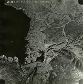
2019.10.4.41406 · Item · 8 Sept. 1969
Part of Lockwood Survey Corporation Ltd. collection

This remote-sensing aerial photograph was taken by Lockwood Survey Corporation Ltd. under contract for the B.C. Forest Service. This historically important aerial photograph depicts the W.A.C. Bennett Dam and Williston Reservoir soon after its flooding in 1968.

The identification coding on these photographs can be interpreted as follows:

  • The largest number on the leftmost side is the frame number for the photograph.
  • The following code to the right in the format B) 69-53 is currently unknown, but may refer to an internal project number for the Lockwood Survey Corporation.
  • The 6" may refer to the camera's focal length in inches.
  • Next is "17,150 ASL" which is 17,150 feet Above Sea Level.
  • Following is "152.52" which refers to the camera's focal length in millimeters, which equals 6 inches.
  • The "W1307" may refer to the reel, but that is unconfirmed.
  • "8 SEP 69" is the date the photo was taken.
2019.10.7 · File · 10 Sept. 1969
Part of Lockwood Survey Corporation Ltd. collection

These remote-sensing aerial photographs were taken by Lockwood Survey Corporation Ltd. under contract for the B.C. Forest Service. Some photographs are annotated to show logging activity; clearcuts, slash piles, log booms, and tree debris on the water are also visible in some of the images. No detailed location information or index accompanies the photographs. These historically important aerial photographs depict Williston Lake soon after its creation in 1968 with the building of the W.A.C. Bennett Dam on the Peace River. Also depicted are the rivers and tributaries that empty into the Williston Reservoir, such as the Finlay River, the Ospika River, and the Omineca River.

The identification coding on these photographs can be interpreted as follows:

  • The largest number on the leftmost side is the frame number for the individual photograph.
  • The following code to the right in the format "B) 69-53" is currently unknown, but may refer to an internal project number for the Lockwood Survey Corporation.
  • The 6" may refer to the camera's focal length in inches.
  • Next is "17,150 ASL" which is 17,150 feet Above Sea Level.
  • Following is "152.52" which refers to the camera's focal length in millimeters, which equals 6 inches.
  • The "W1308" may refer to the reel, but that is unconfirmed.
  • "10 SEP 69" is the date the photos were taken.
2019.10.3 · File · 8 Sept. 1969
Part of Lockwood Survey Corporation Ltd. collection

These remote-sensing aerial photographs were taken by Lockwood Survey Corporation Ltd. under contract for the B.C. Forest Service. Some photographs are annotated to show logging activity; clearcuts, slash piles, log booms, and tree debris on the water are also visible in some of the images. No detailed location information or index accompanies the photographs. These historically important aerial photographs depict Williston Lake soon after its creation in 1968 with the building of the W.A.C. Bennett Dam on the Peace River. Also depicted are the rivers and tributaries that empty into the Williston Reservoir, such as the Finlay River, the Ospika River, and the Omineca River.

The identification coding on these photographs can be interpreted as follows:

  • The largest number on the leftmost side is the frame number for the individual photograph.
  • The following code to the right in the format B) 69-53 is currently unknown, but may refer to an internal project number for the Lockwood Survey Corporation.
  • The 6" may refer to the camera's focal length in inches.
  • Next is "17,150 ASL" which is 17,150 feet Above Sea Level.
  • Following is "152.52" which refers to the camera's focal length in millimeters, which equals 6 inches.
  • The "W1307" may refer to the reel, but that is unconfirmed.
  • "8 SEP 69" is the date the photos were taken.
2019.10.4 · File · 8 Sept. 1969
Part of Lockwood Survey Corporation Ltd. collection

These remote-sensing aerial photographs were taken by Lockwood Survey Corporation Ltd. under contract for the B.C. Forest Service. Some photographs are annotated to show logging activity; clearcuts, slash piles, log booms, and tree debris on the water are also visible in some of the images. No detailed location information or index accompanies the photographs. These historically important aerial photographs depict Williston Lake soon after its creation in 1968 with the building of the W.A.C. Bennett Dam on the Peace River. Also depicted are the rivers and tributaries that empty into the Williston Reservoir, such as the Finlay River, the Ospika River, and the Omineca River.

The identification coding on these photographs can be interpreted as follows:

  • The largest number on the leftmost side is the frame number for the individual photograph.
  • The following code to the right in the format B) 69-53 is currently unknown, but may refer to an internal project number for the Lockwood Survey Corporation.
  • The 6" may refer to the camera's focal length in inches.
  • Next is "17,150 ASL" which is 17,150 feet Above Sea Level.
  • Following is "152.52" which refers to the camera's focal length in millimeters, which equals 6 inches.
  • The "W1307" may refer to the reel, but that is unconfirmed.
  • "8 SEP 69" is the date the photos were taken.
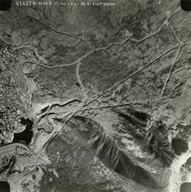
2019.10.4.41407 · Item · 8 Sept. 1969
Part of Lockwood Survey Corporation Ltd. collection

This remote-sensing aerial photograph was taken by Lockwood Survey Corporation Ltd. under contract for the B.C. Forest Service. This historically important aerial photograph depicts the W.A.C. Bennett Dam and Williston Reservoir soon after its flooding in 1968.

The identification coding on these photographs can be interpreted as follows:

  • The largest number on the leftmost side is the frame number for the photograph.
  • The following code to the right in the format B) 69-53 is currently unknown, but may refer to an internal project number for the Lockwood Survey Corporation.
  • The 6" may refer to the camera's focal length in inches.
  • Next is "17,150 ASL" which is 17,150 feet Above Sea Level.
  • Following is "152.52" which refers to the camera's focal length in millimeters, which equals 6 inches.
  • The "W1307" may refer to the reel, but that is unconfirmed.
  • "8 SEP 69" is the date the photo was taken.
2019.10.6 · File · 9 Sept. 1969
Part of Lockwood Survey Corporation Ltd. collection

These remote-sensing aerial photographs were taken by Lockwood Survey Corporation Ltd. under contract for the B.C. Forest Service. Some photographs are annotated to show logging activity; clearcuts, slash piles, log booms, and tree debris on the water are also visible in some of the images. No detailed location information or index accompanies the photographs. These historically important aerial photographs depict Williston Lake soon after its creation in 1968 with the building of the W.A.C. Bennett Dam on the Peace River. Also depicted are the rivers and tributaries that empty into the Williston Reservoir, such as the Finlay River, the Ospika River, and the Omineca River.

The identification coding on these photographs can be interpreted as follows:

  • The largest number on the leftmost side is the frame number for the individual photograph.
  • The following code to the right in the format "B) 69-53" is currently unknown, but may refer to an internal project number for the Lockwood Survey Corporation.
  • The 6" may refer to the camera's focal length in inches.
  • Next is "17,150 ASL" which is 17,150 feet Above Sea Level.
  • Following is "152.52" which refers to the camera's focal length in millimeters, which equals 6 inches.
  • The "W1308" may refer to the reel, but that is unconfirmed.
  • "9 SEP 69" is the date the photos were taken.
2019.10.5 · File · 9 Sept. 1969
Part of Lockwood Survey Corporation Ltd. collection

These remote-sensing aerial photographs were taken by Lockwood Survey Corporation Ltd. under contract for the B.C. Forest Service. Some photographs are annotated to show logging activity; clearcuts, slash piles, log booms, and tree debris on the water are also visible in some of the images. No detailed location information or index accompanies the photographs. These historically important aerial photographs depict Williston Lake soon after its creation in 1968 with the building of the W.A.C. Bennett Dam on the Peace River. Also depicted are the rivers and tributaries that empty into the Williston Reservoir, such as the Finlay River, the Ospika River, and the Omineca River.

The identification coding on these photographs can be interpreted as follows:

  • The largest number on the leftmost side is the frame number for the individual photograph.
  • The following code to the right in the format "B) 69-53" is currently unknown, but may refer to an internal project number for the Lockwood Survey Corporation.
  • The 6" may refer to the camera's focal length in inches.
  • Next is "17,150 ASL" which is 17,150 feet Above Sea Level.
  • Following is "152.52" which refers to the camera's focal length in millimeters, which equals 6 inches.
  • The "W1308" may refer to the reel, but that is unconfirmed.
  • "9 SEP 69" is the date the photos were taken.
2012.13.2.01 · Subseries · 1970-2011
Part of J. Kent Sedgwick fonds

Subseries includes research material created and collected by Kent Sedgwick relating to the incorporation of the City of Prince George. Topics include the naming of the City of Prince George, city boundaries, the city amalgamation with Fort George and South Fort George, city census records, and mayors of Prince George.

2012.13.2.01.03 · File · [between 1970 and 1980]
Part of J. Kent Sedgwick fonds

File consists of photocopies and notes relating to the boundary expansions of the city of Prince George since its incorporation. Includes a graph drawn by Kent Sedgwick regarding the addition of land and water each year of the boundary expansion and a "Proclamation" photocopy from the B.C. Gazette (23 Apr. 1953). Also includes 5 maps: "City of Prince George Boundary Expansions since Incorporation in 1915" (1979 or 1980); "City of Prince George" (Feb. 1979); "Map of Prince George" (between 1970 and 1985); "Study Area Boundaries" (Mar. 1977); and "City of Prince George" (Feb. 1972).

"British Columbia" 1970 map
2012.13.6.49 · File · 1970
Part of J. Kent Sedgwick fonds

Item is an original 1970 map of British Columbia with annotations of Kent's travels throughout the province highlighted in yellow. The map was originally published by the Department of Lands, Forests and Water Resources in British Columbia.

E.P. 646.3
2016.5.1.87 · File · [1970-2015]
Part of Harry Coates fonds

File consists of photocopied documentation for E.P. 646.3 Reciprocal Planting of Spruce Provenances in the Rocky Mountain Trench along with printed satellite maps from Bing Maps. File also includes a map of Buckhorn Barn showing reserve no. EP 505, research & R.N. projects. Map includes annotations for EP 646.3.

2016.5.5.01 · File · [19-?]
Part of Harry Coates fonds

File consists of trail maps and recreation guides from various places in British Columbia, especially Northern British Columbia. Maps include:

  • British Columbia Road Map and Parks Guide
  • Northwood Pulp and Timber Limited Forest Operations Recreation Map
  • Provincial Parks of Northern British Columbia
  • Visitor's Guide: Mackenzie Woodlands
  • Visitors Guide: Mackenzie Woodlands
  • Mackenzie Forest District Recreation Map
  • Dawson Creek Forest District Recreation Map
  • Morice Forest District Recreation Map
  • Fort St. James Forest District Recreation Map
  • Lakes Forest District Recreation Map
  • Cariboo Forest Region Recreation Map
  • Lakes District Visitors Map
  • Prince George Forest District Recreation Map
  • Vanderhoof Forest District Recreation Map
  • Fort St. John Forest District Recreation Map
  • Cariboo Forest Region Recreation Map (East)
  • Robson Valley Forest District Recreation Map
  • Fort Nelson Forest District Recreation Map
  • Forest Service Recreation Sites: Valemount - Blue River
  • Forest Service Recreation Sites: McBride - Goat River
  • Forest Service Recreation Sites: Prince George West
  • Forest Service Recreation Sites: Moberly - Sukunka
  • Forest Service Recreation Sites: Nation - Takla
  • Forest Service Recreation Sites: Murrat - Kiskatinaw
  • Recreation Road Map for the Prince George Forest Area (1987-1988)
  • Recreation Road Map for the Prince George Forest Area (1997)
  • The Bobtail Forest Service Road Tour
  • Forest Recreation Map: Northwood Pulp and Timber Limited
  • Forest Operations Recreation Map: Northwood pulp and timber limited
  • Forest Service: Recreation Sites Williston/Mackenzie
  • Forest Service Recreation Sites Prince George West
  • The Official Prince George Tourist Street Map
  • Ecological Reserves in British Columbia (July 1990)
  • Prince George Forest District map (April 1990) with annotations regarding trials.
Forest Cover Map 93J-10-d
2016.5.5.02 · Item · [197-?]
Part of Harry Coates fonds

Item is a Forest Cover Map, 93J-10-d, annotation on the back reads Carpet Lake. Geographic features include Merton Lake and Peculiar Lake.

Wansa Thinning Trials
2016.5.1.35 · File · [19-?]
Part of Harry Coates fonds

File consists of photocopied data tables for Wansa Thinning Trials and map of Wansa Sanitation-Spacing Trials (Sx 80405).

B.C. Ghost Town Map
2000.23.1.070.13 · Item · [between 1970 and 1987]
Part of Audrey Smedley L'Heureux fonds

This map depicts where to find ghost towns, forts, First Nation villages, and sites with supposed hidden treasures in British Columbia.

2012.13.2.05.09 · File · 1970-2007
Part of J. Kent Sedgwick fonds

File consists of notes, clippings, and reproductions relating to Indigenous Peoples of British Columbia. Includes: "A selected list of publications on the Indians of British Columbia" published by the British Columbia Provincial Museum (1970) and "Les Indiens Des Cordilleres" printed by the National Museum of Canada (7 Feb. 1939). File also includes a map titled "Native Lands, then and now" depicting British Columbia including outlines of Indigenous territories and a smaller map of Canada with Indigenous language families; the backside of the map is titled "What are you ready for" and includes a timeline of information and Indigenous history in British Columbia (1990).

2019.10.8 · File · 1 Aug. 1970
Part of Lockwood Survey Corporation Ltd. collection

These remote-sensing aerial photographs were taken by Lockwood Survey Corporation Ltd. under contract for the B.C. Forest Service. Some photographs are annotated to show logging activity; clearcuts, slash piles, log booms, and tree debris on the water are also visible in some of the images. No detailed location information or index accompanies the photographs. These historically important aerial photographs depict Williston Lake soon after its creation in 1968 with the building of the W.A.C. Bennett Dam on the Peace River. Also depicted are the rivers and tributaries that empty into the Williston Reservoir, such as the Finlay River, the Ospika River, and the Omineca River.

The identification coding on these photographs can be interpreted as follows:

  • The largest number on the leftmost side is the frame number for the individual photograph.
  • The following code to the right in the format "B) 70-38" is currently unknown, but may refer to an internal project number for the Lockwood Survey Corporation.
  • The 6" may refer to the camera's focal length in inches.
  • Next is "17,150 ASL" which is 17,150 feet Above Sea Level.
  • Following is "152.63" which refers to the camera's focal length in millimeters, which equals 6 inches.
  • The "W1339" may refer to the reel, but that is unconfirmed.
  • "1 AUG 70" is the date the photos were taken.
Transportation
2012.13.2.15 · Subseries · 1970-2010
Part of J. Kent Sedgwick fonds

Subseries consists of material collected and created by Kent Sedgwick for research regarding transportation. Includes notes and research on airplanes, specifically Prince George aviation and the Junkers aircraft named "The City of Prince George"; highway transportation; the Grand Trunk Pacific Railway; ferry boat service including the Fraser River Fort George ferry, the Isle Pierre ferry, and the Miworth ferry; the Pacific Great Eastern Railway line; the British Columbia Railway; and the Canadian National Railway. Also includes essays and typed documents on railway history in Prince George.

Parks and Outdoor Recreation
2012.13.2.14 · Subseries · 1970-2011
Part of J. Kent Sedgwick fonds

Subseries consists of material collected and created by Kent Sedgwick for research regarding parks and outdoor recreation in Prince George. Material on parks includes Fort George Park (renamed to Lheidli T’enneh Memorial Park in 2015); Cottonwood Island Park; Connaught Hill; Moore's Meadow; L.C. Gunn Park; the Nechako Cutbanks; Paddlewheel Park; Monkman Provincial Park; Fraser Canyon Park; and Carp Lake. Also includes information on the creation of plaques and monuments, including the Alexander Mackenzie monument; the “Arrival of Steel” CN railway plaque; heritage interpretative signs for the Grand Trunk Pacific Railway; the Millar addition; and flooding and rivers. The files consists of various pamphlets and correspondence regarding the development of parks and the creation of interpretive materials.

2019.10.9 · File · 1 Aug. 1970
Part of Lockwood Survey Corporation Ltd. collection

These remote-sensing aerial photographs were taken by Lockwood Survey Corporation Ltd. under contract for the B.C. Forest Service. Some photographs are annotated to show logging activity; clearcuts, slash piles, log booms, and tree debris on the water are also visible in some of the images. No detailed location information or index accompanies the photographs. These historically important aerial photographs depict Williston Lake soon after its creation in 1968 with the building of the W.A.C. Bennett Dam on the Peace River. Also depicted are the rivers and tributaries that empty into the Williston Reservoir, such as the Finlay River, the Ospika River, and the Omineca River.

The identification coding on these photographs can be interpreted as follows:

  • The largest number on the leftmost side is the frame number for the individual photograph.
  • The following code to the right in the format "B) 70-38" is currently unknown, but may refer to an internal project number for the Lockwood Survey Corporation.
  • The 6" may refer to the camera's focal length in inches.
  • Next is "17,150 ASL" which is 17,150 feet Above Sea Level.
  • Following is "152.63" which refers to the camera's focal length in millimeters, which equals 6 inches.
  • The "W1339" may refer to the reel, but that is unconfirmed.
  • "1 AUG 70" is the date the photos were taken.
2013.6.35.16 · Item · Mar. 1971
Part of David Davies Railway Collection

Map depicts rail lines in the BC lower mainland, including BC Hydro Railway, Burlington Northern Railway, the Canadian Pacific Railway, the Canadian National Railway, and the Pacific Great Eastern Railway.

2012.13.2.21.08 · File · [between 1972 and 1979]
Part of J. Kent Sedgwick fonds

File consists of maps and plans depicting the Cottonwood Island area in Prince George. Includes:

  • "Plan of Subdivision pursuant to the replotting provisions of the Municipal Act of Parcel A of Plan 25046, of District Lots 343, 662, 1511, 4736, and 7813, Cariboo District" by McWilliam, Whyte, Goble & Associates B.C. Land Surveyors for the City of Prince George, 26 July 1979 (reproduction on 2 sheets)
  • "Cottonwood Island" original draft map with annotations by Kent Sedgwick; the map may have been created by Sedgwick during his time as Senior City Planner with the City of Prince George [197-?]
  • "Prince George B.C., Fraser Subdivision, Mile 146.05" plan for Canadian National Railways by Lockwood Survey Corporation Ltd., 1967. This very large technical drawing shows CN leases and private property buildings on Island Cache in detail.
  • McWilliam-Whyte-Goble & Associates, B.C. Land Surveyors, "Plan Showing Sections in Proposed Lakeland Mill Site", July 1978 (original reproduction).
  • Carroll, Hatch & Associates, "Lakeland Mills (1973) Ltd., Prince George, B.C., Stud Mill Studies, Site Plan", 31 July 1978 (original reproduction).
2020.4.4.01 · File · 1972-1978
Part of G. Gary Runka fonds

File consists of Gary Runka's records during his roles as general manager of the BC Land Commission (appointed 1973) and as the chairman of the Agricultural Land Commission (1975-1978) during its formative years. Includes correspondence, reports, informational material, and maps. Highlights include:

  • A statement by Gordan Gram delivered 30 March 1976 entitled "Land Commission: Acquisition and Land Management"
  • "Brief to the Commission of Inquiry on Property Assessment and Taxation" submitted by the B.C. Land Commission (29 April 1976)
  • "Possibilities for Improved Land Management of Class 4 Lands in ALR: A Report to the British Columbia Land Commission" by Terence Lewis (12 Dec. 1975)
  • Newspaper articles about the Commission's work and Runka's departure in 1978
  • "Script for: Saving the Land - Bernholtz Study Project - A Slide Tape Presentation"
  • "Green Paper on Planning for Agriculture: Food Land Guidelines" from the Ontario Ministry of Agriculture and Food (1977)
  • "Where Have the Farm Lands Gone?" pamphlet (1979)
  • "Official Regional, Settlement, Community Plan Project 1978-1979"
  • "Preserving Agricultural Land: Guidelines for Action" booklet (1978)
  • Gary Runka's 1978 resignation letter

Maps include:

  • Photocopy of BC Provincial Land Commission, "Agricultural Land Reserve Plan, East Kootenay Regional District", map no. 82K/9, base sheet 16 of 17, last amended July 1994.
  • Photocopy of BC Provincial Land Commission, "Agricultural Land Reserve Plan, East Kootenay Regional District", map no. 82G/12, base sheet 8 of 17, last amended Oct. 1995.
  • Photocopy of BC Provincial Land Commission, "Agricultural Land Reserve Plan, Thompson-Nicola Regional District", map no. 92L/1, base sheet 14 of 43, original dated August 1974.
  • Photocopy of BC Provincial Land Commission, "Agricultural Land Reserve Plan, Thompson-Nicola Regional District", map no. 92L/2, base sheet 15 of 43, last amended Oct. 1998.
  • Reproduction of B.C. Land Inventory (C.L.I.) base map 82E/3 showing Agricultural Land Reserve Boundary in the Okanagan-Similkameen Regional District, amended to July 1996.
  • Reproduction of B.C. Land Inventory (C.L.I.) base map 82E/6 showing Agricultural Land Reserve Boundary in the Okanagan-Similkameen Regional District, originally dated February 1974.
  • Reproduction of B.C. Land Inventory (C.L.I.) base map 82E/12 showing Agricultural Land Reserve Boundary in the Okanagan-Similkameen Regional District, amended to Oct. 1995.