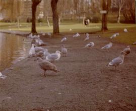
Photograph depicts gulls at Lost Lagoon in Vancouver, B.C.
Photograph depicts a dogwood tree in front of the garden at 1057 Beach Ave. in Vancouver. The photo is taken looking northeast.
Photograph depicts the dogwood tree in winter at the former site of 1057 Beach Ave. in Vancouver. The view is looking east.
Photograph depicts fields recently cleared from virgin bush on Miracle Breach on Vancouver Island.
Photograph depicts land clearance between Monashee Pass and Lumby, B.C.
Photograph depicts Granite Falls near the Wigwam Inn, Indian Arm, Vancouver, B.C.
Photograph depicts a view of Indian Arm, looking south from Granite Falls.
Photograph depicts Granite Falls and wharf at Indian Arm, looking west from the top of the falls.
Photograph depicts a the shoreline of Vancouver Harbour, looking east from the property line of the Burrard Grain Elevator, 375 Low Level Rd, North Vancouver.
Photograph depicts the view looking north from Diamond Head Lodge in Garibaldi Park, about 20 miles northeast of Squamish. Believed to be "Bookworm range" at 7910 ft.
Photograph depicts the entrance to the Squamish River at Squamish, looking upstream. The pier on the left belongs to the original logging railway, circa 1909-1925.
Photograph depicts a baby seal at C.N. log drop at Cowichan Lake on Vancouver Island.
This remote-sensing aerial photograph was taken by Lockwood Survey Corporation Ltd. under contract for the B.C. Forest Service. This historically important aerial photograph depicts the headwaters of Williston Reservoir soon after its creation in 1968 with the building of the W.A.C. Bennett Dam on the Peace River.
The identification coding on these photographs can be interpreted as follows:
- The largest number on the leftmost side is the frame number for the photograph.
- The following code to the right in the format B) 69-53 is currently unknown, but may refer to an internal project number for the Lockwood Survey Corporation.
- The 6" may refer to the camera's focal length in inches.
- Next is "17,150 ASL" which is 17,150 feet Above Sea Level.
- Following is "152.52" which refers to the camera's focal length in millimeters, which equals 6 inches.
- The "W1307" may refer to the reel, but that is unconfirmed.
- "8 SEP 69" is the date the photo was taken.
This remote-sensing aerial photograph was taken by Lockwood Survey Corporation Ltd. under contract for the B.C. Forest Service. This historically important aerial photograph depicts the W.A.C. Bennett Dam and Williston Reservoir soon after its flooding in 1968.
The identification coding on these photographs can be interpreted as follows:
- The largest number on the leftmost side is the frame number for the photograph.
- The following code to the right in the format B) 69-53 is currently unknown, but may refer to an internal project number for the Lockwood Survey Corporation.
- The 6" may refer to the camera's focal length in inches.
- Next is "17,150 ASL" which is 17,150 feet Above Sea Level.
- Following is "152.52" which refers to the camera's focal length in millimeters, which equals 6 inches.
- The "W1307" may refer to the reel, but that is unconfirmed.
- "8 SEP 69" is the date the photo was taken.
Photograph depicts a a mule deer hunting kill in Lillooet, BC.
Annotated air photograph depicts Scout Island Nature Centre in Williams Lake and surrounding areas.
Slide depicts a tree with apple blossoms in a backyard of a brown house. The yard is surrounded by a wooden fence. The neighbor's white house can be seen next door. Photographed in Kelowna, BC. Original slide description: "Apple Blossom bkyd. Kel."
Slide depicts Kelowna and Casa Loma photographed during the day from across the Okanagan Lake in the Lakeview Heights area. Original slide index description: "Kel & Casa Loma from Lakeview Hts."
Slide depicts a camel and two llamas in an enclosed pasture. The photograph was taken in Kaleden, BC. Original slide index description: "Camel & Llamas in pasture, Kaleden."
Slide depicts a close up of a camel behind a fence. The photograph was taken in Kaleden, BC. Original slide index description: "Camel, Kaleden."
Slide depicts two eagles in an enclosure. The photograph was taken in Kaleden, BC. Original slide index description: "Eagles, Kaleden."
Slide depicts a mixture of bighorn sheep and fallow deer around a trough. The photograph was taken in Kaleden, BC. Original slide index description: "illegible sheep & fallow deer, Kaleden."
Slide depicts a close up of a lion lying on wood shavings in an enclosed area. The photograph was taken in Kaleden, BC. Original slide index description: "lion, Kaleden."
Slide depicts a close up of a llama eating hay. The photograph was taken in Kaleden, BC. Original slide index description: "Llama, Kaleden."
Item is an original report by D.J. Robinson, Game Management Biologist, entitled "Interim Report re Status of Sayward Forest Deer Herds".
Item is a compilation of reproductions titled "Methods Used in B.C. Ungulate Land Inventory".
Item is a BC Ministry of Environment and Parks report entitled "1987 Coastal Skeena Moose Survey".
Item is an original BC Parks report entitled "Preservation and Management of the Grizzly Bear in B.C. Provincial Parks: The Urgent Challenge".