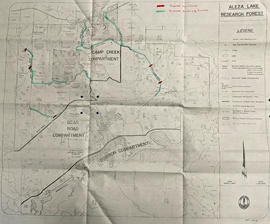
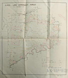
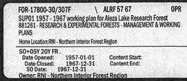
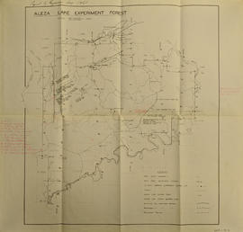
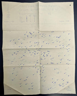
Fonds consists of documents providing information on the Columbia Cellulose Company, Limited covering the period of 1959-1970. These documents detail the company’s history, historical and geographical context, and plans for the future. Files often include photographs, maps, and technical drawings of the mills.
Sem títuloSeries consists of documents providing information on the Columbia Cellulose Company, Limited including its history, historical and geographical context, and plans for the future. These documents often include photographs, maps, and technical drawings of the mills. Series consists of Skeena Kraft press kit; Feasibility Study of Nass River Valley Log Transport Systems; A Summary History and Progress; Development Study: Northern resources; Columbia Cellulose Company, Limited.
File consists of a folder containing documents describing Skeena Kraft Limited. Folder consists of:
- Svenska Cellulosa Aktiebolaget--A Forest Products Giant
- Columbia Cellulose Company, Limited--A Corporate History
- Two World-Wide Sales Organizations to Market Skeena Kraft Pulp
- Skeena Kraft Limited Adopts Distinctive Housemark Symbol Adapted from Sun Totem, Kee-War-Kow, Family Crest of Sky People
- The Nass and Skeena Valleys--A New Economic Region Terrace and Prince Rupert are Hubs in Finance and Services
- MISSING: Twinriver Timber Limited: New Company Created to Administer Two Tree Farm Licence Areas
- The Forests Behind the Coast Range Produce Superior Pulp
- Efficient New Woodroom Highlights Skeena Mill
- Integrating Two Power Systems--A Marriage with Convenience One Power Group Serves Two Mills
- Pulping Group Features Flexible Bleaching Sequence and World's Largest Flakt Drier
- New Dams Create Huge Storage Area for Skeena Water Supply
- Advanced Process Control Techniques Employ Computers Extensively
- Skeena Kraft Mill Quality Control and Process Control Tune Mill to Produce Prime Quality Pulps
- Co-ordination and Administration of Construction and Design of Skeena Kraft Shared by H.A. Simons and Central Engineering of Columbia Cellulose
- Purchasing and Traffic Departments Buy and Move More than 25,000 Tons of Materials During Skeena Kraft Construction Co-ordinated Sea and Land Transport System Introduced
- Skeena Kraft--Hundreds of New Jobs Canada-Wide Recruiting Programme Attracts New Workers to Growing Nass-Skeena Region;
- Also includes 19 photographs; 12 technical drawings and diagrams; 2 maps;
- Promotional pamphlet "The Skeena Kraft Story."
Item is a map of British Columbia's Status of Sustained-Yield Forestry Programme as at 31 December 1962. The map has been annotated to show forest area surveyed by Celgar Ltd. as base for new kraft mill.
Series consists of maps, technical drawings, and other oversize material collected by Gary Runka that are not associated with specific Land Sense Ltd. client jobs.
Photocopied map depicts mineral and coal mining properties in north western British Columbia.
File consists of photocopied data tables for Wansa Thinning Trials and map of Wansa Sanitation-Spacing Trials (Sx 80405).
File consists of several maps indicating the locations of plots and 3 detailed maps of specific plots. File also includes photographs of cleared forests and a "P.G. District Demonstration Plots: Establishment Report".
File consists of "History of the Buckhorn Research Demonstration Area Prince George Forest Region" by J. Revel Nov. 1988 and maps, diagrams, and documentation for:
- Sx 84119G
- Sx 87109G
- EP 976.02.02
- EP 697
- EP 1185
- File also include three large maps: a reproduction of a BC Forest Service Aleza Lake Research Forest map, North Eastern British Columbia Fire Location Map (1961), and map of Summit Lake, Cariboo District B.C. (1966).
Series consists of maps, and road maps, and trail guides from various communities and regions in Northern and Central BC. Series includes Forest Cover Maps and maps related to BC forest and natural resource management.
This map depicts the location of the Archie Creek site, annotated on a photocopied 93I.011 BC government map (undated).
Fonds consists of material created and collected by wildlife biologist Grant Hazelwood in relation to his work and research regarding wildlife, habitat, and wilderness parks. Includes material regarding Hazelwood's Tailed Frog (Ascaphus truei) research. Also includes records regarding his contracted biologist work via his consultancy business, Alpenglow Resources, on the BC Ministry of Environment's "Upper Nass Assessment Project", a project that included the biophysical mapping of the Northwest-Klappan Road Access Area.
Sem títuloFile consists of an original and photocopied maps collected by Grant Hazelwood primarily in conjunction with work for the Upper Nass Assessment Project. The majority consist of Canadian National Topographic System (NTS) maps annotated with draft biophysical mapping, collected species inventory data, area boundaries, or other information for the project.
Reproduced map on mylar depicts the Aleza Lake timber reserve near Aleza Lake, BC.
Map is a photocopy reproduction of the Aleza Lake Experiment Forest development map that was included in the appendix to the 1957 Aleza working plan.
Map is a photocopy reproduction of the Aleza Lake Experiment Forest permanent plot map that was included in the appendix to the 1957 Aleza working plan.
Map is a photocopy reproduction of the Aleza Lake Experiment Forest map that was included in the appendix to the 1957 Aleza working plan.
Map is a mylar reproduction of an Aleza Lake Forest Reserve map.
Item is a hand-drawn map of a plot in the Aleza Lake Research Forest. Individual trees are marked and numbered.
Item is a forest cover map for Aleza Lake Research Forest (Special Use Permit 19070). Shows experimental plots and timber sale areas.
Mylar map is a plot map of a research plot at the Aleza Lake Research Forest. Provides date the plot was established, the harvest history, the silviculture history, remeasurement history, and information about individual trees.
Map depicts structural stages in the Aleza Lake Research Forest. Shows areas of: pioneer growth, shrub/herb, pole saplings, young forests, mature forests, and old forests. Ecosystem classification and mapping by Oikos Ecological Services Ltd.
Map indicates locations of research trials and permanent plots in the Aleza Lake Research Forest. Map produced by Madrone Consultants.
Original linen map depicts mining claims in the Cassiar District of British Columbia that were located in 1900-1901: L. 115 Princess Louise, L. 310 North Star, L. 311 Bonanza, L. 309 Emerald, and L. 312 Emma.
This map depicts the pit layout and estimated waste extraction areas for 6380 bench. Extraction dates accompanied by its total tonnages are located within each planned area. Certain extraction dates are labeled with bench numbers. Annotated details include extraction dates, approximate total tonnages per area as well as extraction dates, total planned and broken tonnages, total tonnages from December 31, 1970 from a survey done in September 1, numerical bench markers as well as a rough colored legend depicting extraction month by color. The hand drawn plan consists of solid lines drawn with green, yellow, red and lead pencils.
This map depicts the pit layout and estimated waste extraction areas for 6320 bench. Extraction dates accompanied by its total tonnages are located within each planned area. Certain extraction dates are labeled with bench numbers. Annotated details include extraction dates, approximate total tonnages per area accompanied by extraction dates, total planned tonnages, total tonnages from December 31, 1971 as well as a rough colored legend depicting extraction month by color. The hand drawn plan consists of solid lines drawn with green, red, orange and lead pencils.
Fonds consists of textual, photographic, cartographic, electronic and promotional films/video recordings related to the mining operations of Cassiar Asbestos Mining Corporation (CAMC) and creation of Cassiar townsite. CAMC records primarily consist of records related to mining operations including construction, engineering, daily mining operations, administration of CAMC, tallies of extractions, labour and union activities, corporate events and visits by dignitaries. Townsite records are primarily visual representations of townsite construction, including the creation of health, education and community services including Cassiar's private hospital, school, library, as well as townsite images. Photographs include documentation of natural and man-made landscapes within the Cassiar region of Northern BC. Other holdings include a near complete run of Cassiar's community newspaper.
Sem títuloThis map depicts the generalized pit layout and estimated waste extraction areas for benches 5840 and 5870. Annotated details include numerical bench markers as well as extraction dates. The hand drawn plan consists of solid and dotted lines drawn with green and red pencil.
This map depicts the pit layout and estimated waste extraction areas for 5840 bench for the end of September to November. Extraction dates, approximate extraction tonnages and ore, waste and talus locations are included throughout the plan. Annotated details include numerical bench markers, extraction dates, approximate total tonnages as well as waste and ore tonnage calculations for October. The hand drawn plan consists of solid and broken lines drawn with red, blue, orange and lead pencils as well as black ink.
This map depicts the pit layout and estimated waste extraction areas for 5870 bench for the end of August to November. Extraction dates, approximate extraction tonnages and ore, waste and talus locations are included throughout the plan. Annotated details include numerical bench markers, extraction dates, approximate extraction tonnages, ore, waste and talus locations as well as waste, ore, talus and total tonnage calculations for October. The hand drawn plan consists of solid and broken lines drawn with red, blue, orange and lead pencils as well as black ink.
Series consists of cartographic materials including maps and blueprints of the Aleza Lake Research Forest. The maps reflect permanent sample plots and other study areas. The blueprints outline details for the development of a Ranger Station.
Map reflects forest type boundary line, bogs and swampy non-forested areas, creeks, lakes, rivers, tree species labels of spruce, balsam, and birch, stand descriptions, historical timber sale boundaries, stand history symbol, gravelled secondary roads, unimproved old roads, management compartment boundary, research forest boundary, ecological reserve boundary, and old growth emphasis areas.
Large scale map shows Aleza Lake Research Forest permanent sample plot 112. Includes information about live and dead trees and their species (spruce, balsam, birch, douglas fir). Also includes remeasurement history. Plot 112 was established in 1926 and is an unlogged, old growth, uneven aged, spruce-balsam stand.
Map commissioned from Ministry of Forests Prince George Region from Madrone Consultants shows an Aleza Lake Research Forest TRIM Base Map. Map is 4 of 6. Map shows the following: roads, old roads, buildings, rail line, transmission line, definite streams, intermittent streams, indefinite streams, marshes, swamps, lakes, wooded area boundaries, intermediate contour lines (20m intervals), and index contour lines (100m intervals).
Map commissioned from Ministry of Forests Prince George Region from Madrone Consultants shows Aleza Lake Research Forest Terrain Resource Inventory Mapping (TRIM). Depicts roads, area boundaries, swamps, streams, marshes, contour lines and index lines.
Map reflects reserve boundary, roads, trails, 20 feet contour intervals, air photo centre, declination, swamps, and mile post at the Aleza Lake Experiment Forest.
File contains original copy of the 1957 - 1967 working plan for the Aleza Lake Research Forest.
File contains typed file notes and charts of remeasured experimental plots, as well as a floppy disk