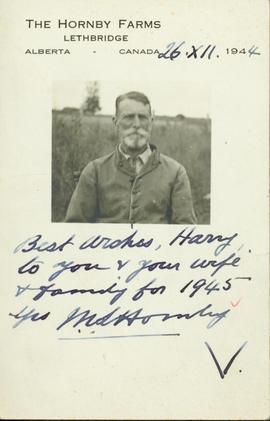
File consists of "Protocol for the Creation of Forest Carbon Offsets in British Columbia," a printed web resource: "Trees for Change," and presentation pages on "B.C. Forest Carbon Offset Investment Opportunities."
Image depicts Bennett Lake near Carcross, Y.T.
Image depicts the train station in Carcross, Y.T.
File consists of two original unbound volumes of the draft report "Carcross Valley - Marsh/Tagish Lakes - Atlin Road Land Management Planning Project" released September 1979 by the Department of Indian Affairs and Northern Development and the Government of the Yukon. Volume 1 consists of "Review Framework and Resource Data" and Volume 2 consists of "Resource Data Maps".
File contains one postcard dated January 5, 1981 from Japan.
File contains a thank you card for a wedding gift.
File contains one postcard dated December 21, 1987.
File contains one undated card expressing birthday wishes.
File contains a postcard postmarked September 11, 1964; includes miscellaneous textual material.
File contains one postcard from New York City.
File contains one personal postcard.
File contains one post card dated April 6, 1982 concerning the mailing of a cheque.
File contains a Christmas card.
File contains one personal postcard postmarked October 10, 1991.
File contains one note card dated November 17, 1977 concerning the purchase of a work by Pat Lane.
File contains one undated card concerning personal matters.
File contains one personal postcard dated June 15, 1981.
File contains one personal post card postmarked October 25, 1982.
File contains one post card dated March 7, 1984 concerning the protest staged by students and Nelson residents in Vancouver and Victoria against the proposed closure of the David Thompson University Centre.
File contains an undated card expressing Season's Greetings signed by Allan, Paddy, [Glen] and Sonia.
File contains one note card requesting information.
File contains an undated thank you card with personal message.
Card consists of a photograph of (presumably) M.S. Hornby and reads: "The Hornby Farms, Lethbridge, Alberta, Canada, 1944: Best wishes Harry to you & your wife & family for 1945. Yrs M.S. Hornby".
File consists of Christmas cards, invitations, ribbons, programmes and other memorabilia collected by Bea Dezell while her husband was mayor of Prince George.
File contains cards with illegible signatures.
File consists of a photocopied version of the 1931 publication by C.R. Knowles entitled "The Care and Operation of Track Motor Cars".
File consists of correspondence sent to the "Prince George Citizen" about a lunch and lecture series and notes for a presentation of the career opportunities for prospective women's studies students.
Series consists of records relating to Grant Hazelwood's career as a wildlife biologist.
Series consists of annual reports, correspondence, newspaper clippings, records of employment, a Retirement Party guest book, business cards, invitations, speeches, appointment announcements, pamphlets, Bridget Moran's "Oath of Allegiance; Office and Revenue to the Government of British Columbia", social work reports, contracts, copies of Employee Earnings Statements, background material on the case Hale vs. Her Majesty the Queen, and social work notebooks all pertaining to Bridget's career as a social worker with the Province of British Columbia and the Prince George School District, and as a member of the College of New Caledonia (CNC) Board, the Legal Services Society of B.C. and People on Welfare.
Photograph taken at terrace gardens, Government House in Victoria, B.C.
Image depicts a log house at an uncertain location; the slide is simply labelled "Cariboo."
Fonds consists of records relating to the operations of the Cariboo Action Training Society.
File consists of Ernie Kaesmodel's copy of "Cariboo Chronicles" by John Roberts. The booklet is signed by the author. The booklet is accompanied by a letter from Rip Kitchen to Ernie Kaesmodel regarding the "Cariboo Chronicles" booklet and provides other local historical anecdotes.
A colour plan drafted on a tracing paper illustrating roads and subdivisions of the surrounding areas near Princ George. Mossvile Road is identified on the plan. Produced by Central Planning and Management Consulting LTD.
Item is a photocopied map depicting the Cariboo district of British Columbia, in the vicinity of Summit Lake and the Salmon River.
A blueprint of a plan re subdivision of Cariboo district. Produced by McWilliam, Whyte, Goble, and Associates, B.C. Land Surveyors Prince George - Kamloops - Smithers. Ospika Boulevard, Pinewood Ave, Massey Ave and etc. are identified on the plan.
Five b&w copies of a plan re Plan of Subdivision of Part of Rem. Parcel B (C5411) of District Lot 71, Cariboo District. Produced by McWilliam-Wyte-Goble and Associates British Columbia Land Surveyors Kamloops-Prince George-Smithers-Salmon Arm-Clearwater. MacKenzie Ave., Rose Street and 2nd Ave are identified on the plans.
A b&w subdivision plan of Cariboo District. NESS Lake Road is identifed on the plan. It includes legend.
A b&w plan re subdivision of part of Lot 1, plan 23398. District lot 4028. Northwesterly 156.73 Acres of District Lot 4028 Cariboo District - British Columbia.
Two b&w compatible subdivision plans which illustrate a region in Cariboo district. Chief Lake Road is identified on the plan.
A blueprint proposed Plan of Subdivision of REM. Lot A, Plan 17100, D.L.8174, Cariboo District. Produced by McWilliam, Whyte, Goble, and Associates, BC Land Surveyors Prince George - Kamloops - Smithers. Pinewood Ave, Ospika Boulevard, Dufferin Ave are identifed on the plan. It illustrates blocks, lots and subdivision of lands.
A b&w (photocopy) plan of Subdivision of The Remainder of West 1/2 D.L.2413, Cariboo Districtis, produced by McWilliam, Whyte, Goble, and Associates, B.C. Land Surveyors. Prince George - Kamloops - Smithers.
A Plan of Subdivision of The Remainder of West 1/2 D.L.2413, Cariboo District, produced by McWilliam, Whyte, Goble, and Associates, B.C. Land Surveyors. Prince George - Kamloops - Smithers. This plan shows division of lots and roads.
A plan of Right-of-Way in Lot 26, D.L. 2413, Cariboo District. This plan is produced by McWilliam, Whyte, Gobie, and Associates, B.C. Land Surveyors, Prince George - Kamloops - Smithers. This plan lies within the Fraser Fort George Regional District.
A b&w plan of Right of Way (Easement) in Lots 1 to 4, Lot 6 and Lots 8 to 27. D.L. 2413 Cariboo District, produced by McWilliam-Whyte-Goble and Associates B.C. Land Surveyors Prince George-Kamloops-Smithers. The plan shows division of lots and roads.
Plan of Subdivision of the Remainder of West 1/2 D.L. 2413, Cariboo District. This plan is produced by McWilliam, Whyte, Goble, and Associates, B.C. Land Surveyors Prince George - Kamloops - Smithers. The plan lies within the Fraser Fort George Regional District. This plan shows division of lots and roads.
4 b&w plans on two of which are drafted on tracing papers. Illustrating Proposed Subdivision of D.L. 4228 Cariboo Dist. Except Parcel-A and Plan - 4881 C.D.Produced by Central Planning and Management Counsulting LTD.
North is noted on each tracing.
b&w plan re Proposed Subdivision of D.L. 4228 Cariboo Dist. produced by Central Planning and Management Consulting LTD. The plan illustrates subdivision of areas by the West Lake. Lake Shore Res. II and Lake Shore Res. IV. are identified on the map.
A blueprint plan of a region in Cariboo district. Giscome Road, Hedlund Road are identified on the plan. Plan of Subdivision of Lot 1. Plan 16115 District Lot 636 Cariboo District, British Columbia
A blueprint plan re Tentative Plan of Proposed Subdivision of Blocks A and B District Lot 8501 Cariboo District-B.C. Yellowhead Highway, Bednesti Lake and Tamarac Lake are identified on the plan. Plan is produced by W.D. Usher and Associates Land Surveyors Prince George BC.