Mostrar 671 resultados

Archival description
236 resultados com objetos digitais Mostrar resultados com objetos digitais
Nadleh Whut'en Band core area planning
1996.8.4.75 · Dossiê/Processo · 1990-1996
Parte de Chander Suri fonds

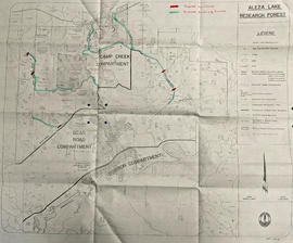
File consists of Carrier Sekani Tribal Council correspondence, briefs, plans, register population data, cost estimates, maps, planning background report, and physical development plan.

"Native Lands then and now"
2012.13.2.05.09.1 · Item · 1990
Parte de J. Kent Sedgwick fonds

The map depicts British Columbia, including outlines of Indigenous tribal territories and a smaller map of Canada with Indigenous language families. The reverse side of the map is titled, "What Are You Ready For" and includes a timeline of information and Indigenous history.

2012.13.2.02.33.01 · Item · [1990?]
Parte de J. Kent Sedgwick fonds

The item is a reproduction of a section of survey map drafted on 18 March 1915 and revised on 23 May 1916. The reproduction was likely created in 1990. The Plan Number is 1268 and highlights the area along the Nechako and Fraser Rivers. The map details subdivisions East of Carney Street, North of Twentieth Avenue and South of Ninth Avenue. Annotations in pencil state different map scale variations and "cemetery setback."

"Parcel Z map 1268"
2012.13.2.02.33.02 · Item · [1990?]
Parte de J. Kent Sedgwick fonds

The item is a reproduction of a section of survey map drafted in 1915. The reproduction was likely created in 1990. The Plan Number is 1268 and highlights the area along the Nechako River. The map details subdivisions East of Carney Street and North of Fifth Avenue. Some original street and avenue names have been crossed out and replaced with handwritten names. Annotation on reverse side of map states, "D.L. 343 Pl. 1268."

"Plan of subdivision D. L. 417 Cariboo District B. C."
2012.13.2.02.33.08 · Item · [1990?]
Parte de J. Kent Sedgwick fonds

The item is a reproduction of a survey map drafted in July 1914. The reproduction was likely created in 1990. The area covered is along the Fraser River and east of Guelph Street. Annotations state, "PL 1409 D. L. 417 HBCo." and highlight different scales of measurement and changed street names.

"Plan of subdivision of D. L. 752 Cariboo"
2012.13.2.02.33.09 · Item · [1990?]
Parte de J. Kent Sedgwick fonds

The item is a reproduction of a survey map drafted in 1 Oct. 1913. The reproduction was likely created in 1990. The area covered is along the Fraser River and west of Linooln Avenue, south of Jackson Street and North of McKinley Street. Annotations state which maps and lots are adjacent to this one. An illegible signature is highlighted.

"Fort George first addition"
2012.13.2.02.33.11 · Item · [1990?]
Parte de J. Kent Sedgwick fonds

The item is a reproduction of a survey map drafted on 20 Nov. 1910. The reproduction was likely created in 1990. The subdivision is lot 2610 G. I. and part of lots 2507 and 2608 G. I. Cariboo District. The area covered is South of 8th Avenue, East of 19th Avenue, North of 8th Street and West of Quinn Street. Annotations state, "Pl. 847," and various notations regarding lot information.

"Plan of subdivision of part of lot 932 Cariboo District"
2012.13.2.02.33.14 · Item · [1990?]
Parte de J. Kent Sedgwick fonds

The item is a reproduction of a survey map drafted on 27 July 1910. The reproduction was likely created in 1990. The area covered is South of Reserve Avenue, East of Victoria, North of Bird Avenue and West of 9th Street. Annotations state, "#796" and highlight the date and registered owner.

"Hixon"
2012.13.2.20.01.2 · Item · [ca. 1990]
Parte de J. Kent Sedgwick fonds

The item is a map depicting the area surrounding the Hixon area in the Cariboo District. There are various annotations in pen and highlighted boundaries.

"Subdivision of lot 1430 G. I. Cariboo District B.C."
2012.13.2.02.33.10 · Item · [1990?]
Parte de J. Kent Sedgwick fonds

The item is a reproduction of a survey map drafted June 1912. The reproduction was likely created in 1990. The area covered is Central Fort George, South of 5th Street, East of Alden Avenue, North of 12th Street and West of Fraser Street. Annotations state, "Plan 1085 Carney Addition."

"Plan of subdivision of D. L. 2508 Cariboo District"
2012.13.2.02.33.12 · Item · [1990?]
Parte de J. Kent Sedgwick fonds

The item is a reproduction of a survey map drafted on 29 Oct. 1910. The reproduction was likely created in 1990. The area covered is South of Princess Street, East of James Avenue, North of 8th Street and West of Rupert Avenue. Annotations state, "Jesse Hodgeson Crown grand in 1910 for $800..."

"Townsite of Fort George subdivision of lot 777"
2012.13.2.02.33.18 · Item · [1990?]
Parte de J. Kent Sedgwick fonds

The item is a reproduction of a survey map drafted in 1909. The reproduction was likely created in 1990. The area covered is South of Fort George Avenue, East of Fraser Street, North of Mount Stephen Avenue, and West of Simpson Street. Annotations state, "Pl. 649."

Crooked Creek Provincial Forest
2012.13.4.09.4 · Item · 1991-1999
Parte de J. Kent Sedgwick fonds

The item is a map depicting the Crooked River Provincial Forest area. Sections of the map are highlighted and coordinates are annotated in ink.

"Paldi New Townsite"
1996.8.4.70 · Dossiê/Processo · 1991-1994
Parte de Chander Suri fonds

File consists of a water supply and sewage disposal study for the townsite of Paldi. Includes maps, correspondence, water licensing information and application, and Bayview Village advertising brochure.

Salmon Portage area, map 93J.027
2012.13.4.09.3 · Item · 1991
Parte de J. Kent Sedgwick fonds

The item is a map depicting the Salmon Portage area along the Salmon River. Various annotations are written in pen and sections of the map are coloured with pencil crayon. The Forest Cover Map identification number is 93J.027.

2020.4.6.297 · Dossiê/Processo · 1991
Parte de G. Gary Runka fonds

File consists of records created and accumulated by Gary Runka over the course of his consultancy work for BC Ministry of Development, Trade and Tourism for the "Natural Resource Tourism Inventory" project in Kamloops. This file was numbered as G.G. Runka Land Sense Ltd. client file #297; that client number may be seen referenced elsewhere in the G. Gary Runka fonds. The Land Sense Ltd. client files generally include records such as correspondence, contracts, invoices, project reports, publications, ephemera, memoranda, maps or map excerpts, legal documents, meeting materials, clippings, and handwritten notes. File also includes 47 accompanying photographs.

Maps include:

  • G.G. Runka Land Sense Ltd., "Natural Resource Tourism, Kamloops Resource Management Area - Tourism Capability Map", Sept. 1991
  • G.G. Runka Land Sense Ltd., "Natural Resource Tourism, Kamloops Resource Management Area - Visual Resource Significance", Sept. 1991
  • Reproduction of BC Ministry of Forests, "Map of Rec. Proj. 900-1-3-4716 (Chuwhels Mtn Trails), June 1967
Salmon Portage area, map 93J.026
2012.13.4.09.5 · Item · 1992
Parte de J. Kent Sedgwick fonds

The item is a map depicting the Salmon Portage area along the Salmon River. Various annotations are written in pen and sections of the map are coloured with pencil crayon. The Forest Cover Map identification number is 93J.026.

2020.4.6.325 · Dossiê/Processo · 1992
Parte de G. Gary Runka fonds

File consists of records created and accumulated by Gary Runka over the course of his consultancy work for North Okanagan Regional District for the "Coldstream Ranch Land Use Concept Plan" project in Coldstream. This file was numbered as G.G. Runka Land Sense Ltd. client file #325; that client number may be seen referenced elsewhere in the G. Gary Runka fonds. The Land Sense Ltd. client files generally include records such as correspondence, contracts, invoices, project reports, publications, ephemera, memoranda, maps or map excerpts, legal documents, meeting materials, clippings, and handwritten notes.

Maps include:

  • Photocopy of BC Land Commission, "Agricultural Land Reserve Plan for the Regional District of North Okanagan - District of Coldstream", 1974.
  • Photocopy of Coldstream topographical map
  • Photocopied segment of District of Coldstream map
  • Regional District of North Okanagan, District of Coldstream, "Official Community Plan", Sheet 1 of 2, 1987. (2 copies)
  • Regional District of North Okanagan, District of Coldstream, "Official Community Plan", Sheet 2 of 2, 1987. (2 copies)
  • Regional District of North Okanagan, District of Coldstream, "Official Community Plan", Sheet 2 of 2, 1987 - annotated and hand col. to show Coldstream Ranch
  • BC Ministry of Crown Lands, "Kalamalka Lake Provincial Park", July 1989
  • Regional District of North Okanagan, "Coldstream", May 1992.
  • Regional District of North Okanagan, "Coldstream Ranch Land Use Concept Plan", July 1992.
2007.1.80.1.11 · Item · [after March 1992]
Parte de Aleza Lake Research Forest fonds

Map reflects forest type boundary line, bogs and swampy non-forested areas, creeks, lakes, rivers, tree species labels of spruce, balsam, and birch, stand descriptions, historical timber sale boundaries, stand history symbol, gravelled secondary roads, unimproved old roads, management compartment boundary, research forest boundary, ecological reserve boundary, and old growth emphasis areas.

Plot maps, photos, and reports
2016.5.1.45 · Dossiê/Processo · 1992-1994
Parte de Harry Coates fonds

File consists of several maps indicating the locations of plots and 3 detailed maps of specific plots. File also includes photographs of cleared forests and a "P.G. District Demonstration Plots: Establishment Report".

2007.1.80.1.10 · Item · [after March 1992]
Parte de Aleza Lake Research Forest fonds

Map reflects forest type boundary line, bogs and swampy non-forested areas, creeks, lakes, rivers, tree species labels of spruce, balsam, and birch, stand descriptions, historical timber sale boundaries, stand history symbol, gravelled secondary roads, unimproved old roads, management compartment boundary, research forest boundary, ecological reserve boundary, and old growth emphasis areas.