Showing 20453 results

Archival description
20453 results with digital objects Show results with digital objects
2007.17.3.36 · Item · [19-]
Part of James Joseph Claxton Photograph Collection

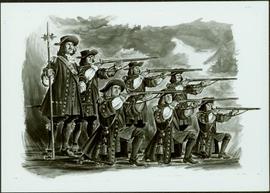
Photograph depicts a painting of a battle regiment consisting of six men holding rifles and one man looking on. Typed annotation glued to verso of photograph reads: "Le Régiment de Carignan-Salières - 1665. This famous regiment was dispatched to Canada (then called New France) by King Louis XIV and disembarked from its small sailing vessels on eastern shores in the spring of 1665. Historically it was an important event. Until then, the colonists had been obliged to provide their own defence and the French regiment was the first military protection they enjoyed."; "Le Régiment de Carignan-Salières - 1665. Ce fameux régiment fut envoyé au Canada (appelé alors Nouvelle-France) par Louis XIV. Au printemps de 1665, il débarquait sur les rivages de l'est. Jusque-là, les colons avaient dû se défendre par leurs propres moyens; c'était la première protection militaire qui leur était offerte. L'arrivée des troupes régulières ramenèrent l'espoir aux colons découragés."

2009.6.1.467 · Item · 1984
Part of The Honourable Iona Campagnolo fonds

Handwritten notation affixed to photographs reads: “Pride of Place on a Young Liberal’s Wall, 1984”; handwritten card from Inniss Photo Service Reg’d, Brockville accompanying the photograph reads: “To Iona Campagnolo, From:- Jan Inniss, My son Scott (+ his mother) attended your recent address in Brockville . . . . I thought you might be interested in seeing what happened to one of your posters . . . A place of honor in his room . . + notice how it takes precedence over the Premier”.

2020.4.8.2.007a · Part · 1971
Part of G. Gary Runka fonds

Photograph is a group portrait of the attendees at the Federal-Provincial Canada Land Inventory Coordinators Meeting in Victoria, March 31-April 1, 1971. Starting from the back row, left to right, attendees included: John Senyk, B.C.; Jim Allin, B.C.; Fred Frederickson, B.C.; Red Ward, Ontario; George Rathwell, Saskatchewan; John Foster, Ottawa, Charlie Rowles, B.C.; David Glover, Ottawa; Bill Yeomans, B.C.; Don Coombs, Ottawa; Harold Hoyt, N.B.; Brian King, Ottawa; Art Benson, B.C.; Scott Johnston, Ottawa; Dan Blower, B.C.; Vic Solman, Ottawa; Don Benn, B.C.; Dick Spilsbury, B.C.; Les Lavkulich, B.C.; Doug Lacate, B.C.; John Wilcox, B.C.; Alf Leahey, B.C.; Mike Romaine, Ottawa; Dick Marshall, B.C.; Gary Runka, B.C.; Norm Sprout, B.C.; Ken Beanlands, Newfoundland; Mick Roberts, Ottawa; Paul Lajoie, Ottawa; Pat Duffy, Ottawa; Bert Brink, B.C.; Merv McKay, Manitoba; Rich Goulden, Manitoba; Reg McCormack, Ottawa; Gerry Howell-Jones, B.C.; Marcel Belzile, Quebec; Paul Deane, Ottawa; Laurie Farstad, B.C.; Stu Scott, Alberta.

2019.10.4.41407 · Item · 8 Sept. 1969
Part of Lockwood Survey Corporation Ltd. collection

This remote-sensing aerial photograph was taken by Lockwood Survey Corporation Ltd. under contract for the B.C. Forest Service. This historically important aerial photograph depicts the W.A.C. Bennett Dam and Williston Reservoir soon after its flooding in 1968.

The identification coding on these photographs can be interpreted as follows:

  • The largest number on the leftmost side is the frame number for the photograph.
  • The following code to the right in the format B) 69-53 is currently unknown, but may refer to an internal project number for the Lockwood Survey Corporation.
  • The 6" may refer to the camera's focal length in inches.
  • Next is "17,150 ASL" which is 17,150 feet Above Sea Level.
  • Following is "152.52" which refers to the camera's focal length in millimeters, which equals 6 inches.
  • The "W1307" may refer to the reel, but that is unconfirmed.
  • "8 SEP 69" is the date the photo was taken.
2019.10.4.41406 · Item · 8 Sept. 1969
Part of Lockwood Survey Corporation Ltd. collection

This remote-sensing aerial photograph was taken by Lockwood Survey Corporation Ltd. under contract for the B.C. Forest Service. This historically important aerial photograph depicts the W.A.C. Bennett Dam and Williston Reservoir soon after its flooding in 1968.

The identification coding on these photographs can be interpreted as follows:

  • The largest number on the leftmost side is the frame number for the photograph.
  • The following code to the right in the format B) 69-53 is currently unknown, but may refer to an internal project number for the Lockwood Survey Corporation.
  • The 6" may refer to the camera's focal length in inches.
  • Next is "17,150 ASL" which is 17,150 feet Above Sea Level.
  • Following is "152.52" which refers to the camera's focal length in millimeters, which equals 6 inches.
  • The "W1307" may refer to the reel, but that is unconfirmed.
  • "8 SEP 69" is the date the photo was taken.
2019.10.4.41405 · Item · 8 Sept. 1969
Part of Lockwood Survey Corporation Ltd. collection

This remote-sensing aerial photograph was taken by Lockwood Survey Corporation Ltd. under contract for the B.C. Forest Service. This historically important aerial photograph depicts the W.A.C. Bennett Dam and Williston Reservoir soon after its flooding in 1968.

The identification coding on these photographs can be interpreted as follows:

  • The largest number on the leftmost side is the frame number for the photograph.
  • The following code to the right in the format B) 69-53 is currently unknown, but may refer to an internal project number for the Lockwood Survey Corporation.
  • The 6" may refer to the camera's focal length in inches.
  • Next is "17,150 ASL" which is 17,150 feet Above Sea Level.
  • Following is "152.52" which refers to the camera's focal length in millimeters, which equals 6 inches.
  • The "W1307" may refer to the reel, but that is unconfirmed.
  • "8 SEP 69" is the date the photo was taken.
2019.10.4.41404 · Item · 8 Sept. 1969
Part of Lockwood Survey Corporation Ltd. collection

This remote-sensing aerial photograph was taken by Lockwood Survey Corporation Ltd. under contract for the B.C. Forest Service. This historically important aerial photograph depicts the headwaters of Williston Reservoir soon after its creation in 1968 with the building of the W.A.C. Bennett Dam on the Peace River.

The identification coding on these photographs can be interpreted as follows:

  • The largest number on the leftmost side is the frame number for the photograph.
  • The following code to the right in the format B) 69-53 is currently unknown, but may refer to an internal project number for the Lockwood Survey Corporation.
  • The 6" may refer to the camera's focal length in inches.
  • Next is "17,150 ASL" which is 17,150 feet Above Sea Level.
  • Following is "152.52" which refers to the camera's focal length in millimeters, which equals 6 inches.
  • The "W1307" may refer to the reel, but that is unconfirmed.
  • "8 SEP 69" is the date the photo was taken.
2013.6.22.2.6 · File · 2010-2013
Part of David Davies Railway Collection

File consists of research material regarding Pacific Great Eastern Railway and BC Rail Dease Lake extension. Predominantly consists of photocopy reproductions, excerpts from books, and clippings from periodicals. Includes the following works: "PGE/BCR: Dease Lake Extension - First 25 Years, 1968 to 1993"; PGE/BCR Dease Lake Branch Progress at end of 1974; "Dease Lake or Bust: BC Rail's Takla Sub, a Socred Mega-Project, Lives On" by Johnson; and "To Alaska or Bust on a Mixed Train: Was BCR's Dease Lake line too late...or too early?" by Patterson and McMillan. Also includes a map of the Dease Lake extension annotated by Davies.

PGE wreck at Seton Portage
2013.6.36.1.047.04 · Item · [6 Aug. 1969]
Part of David Davies Railway Collection

Photo depicts the interchange of passengers of a northbound dayliner around the wreckage of a derailment. Two budd car units from Vancouver can been seen in the background. Passengers were being transferred to a "scratch" train assembled at Lillooet and consisting of a budd car, caboose and a diesal switcher.

PGE wreck at Seton Portage
2013.6.36.1.047.05 · Item · [6 Aug. 1969]
Part of David Davies Railway Collection

Photo depicts the transfer of a Vancouveer to Lillooet dayliner to the unit made up at Lillooet wich consisted of a budd car, caboose and switcher. The scene of the Seton Portage derailment was found 100 yards behind the photo.

PGE wreck at Seton Portage
2013.6.36.1.047.12 · Item · [8 Aug. 1969]
Part of David Davies Railway Collection

Photo depicts a crane #6501 in position to lift locomotive #703. It was about to re-rail one end of the locomotive. Image captured looking towards the south with the shoo-fly in the immediate foreground and Setan Lake in the background.

PGE wreck at Seton Portage
2013.6.36.1.047.09 · Item · [7 Aug. 1969]
Part of David Davies Railway Collection

Photo depicts a distant view of the Seton Portage wreck,. Squamish Shops crane was standing on the minor line of the loop. The crane was self-propelled and after its launch it had broken its drive axle. This was replaced by a standard axle and, therefore, was propelled by a switcher.

PGE wreck at Seton Portage
2013.6.36.1.047.01 · Item · [6 Aug. 1969]
Part of David Davies Railway Collection

Photo depicts a close up view of the rear of the locomotive #703. It was stopped at the head of a freight onn the main line portion of the loop awaiting a southbound loaded freight. Its tracks were derailed, fuel tranks ruptures and a sliver of steel from the box car was forced into its forward tracks. The left side of the cab was also sheared.

PGE wreck at Seton Portage
2013.6.36.1.047.02 · Item · [6 Aug. 1969]
Part of David Davies Railway Collection

Photo depicts the general view of a derailment, looking eastward. The derailed locomotive #703 was found beside a squashed box car. By this time, a PGE bulldozer had prepared a road bed for the wreck.

PGE wreck at Seton Portage
2013.6.36.1.047.06 · Item · [7 Aug. 1969]
Part of David Davies Railway Collection

Photo depicts a shoo-fly that had been built around the Seton Portage wreck. locomotive #703 had stood at this spot just before the switch when the cars of the southbound freight piled into it.

PGE wreck at Seton Portage
2013.6.36.1.047.07 · Item · [7 Aug. 1969]
Part of David Davies Railway Collection

Photo depicts a Pacific Great Eastern working train approaching Seton Portage. It had been diverted from the derailment to fill in a burnt out wooden culvert on the edge of Anderson Lake.

PGE wreck at Seton Portage
2013.6.36.1.047.10 · Item · [7 Aug. 1969]
Part of David Davies Railway Collection

Photo depicts the general view of the clean up of the derailment in Seton Portage. The track in which a speeder stands a gondola car with rolls were the two tracks of the loop. They were both severed and respliced in making the "second edition" of the shoo-fly.

PGE Vancouver
2013.6.36.1.045.43 · Item · 17 Mar. 1968
Part of David Davies Railway Collection

Photograph depicts a Pacific Great Eastern bridge over the Capilano River in northwest Vancouver. Also visible is a switching locomotive.

PGE Squamish
2013.6.36.1.045.44 · Item · Sept. 1966
Part of David Davies Railway Collection

Photograph taken from the depot in Squamish that runs a half a mile spur down to a dumping site beside the Squamish River. Image displays the log dump looking towards the east with the depot in the background, towards the right.

PGE Soda Creek
2013.6.36.1.045.57 · Item · [July 1966]
Part of David Davies Railway Collection

Photograph depicts a wrecked steel box car used by a farmer as some kind of shed with some of the side panels removed.

PGE Shalalth
2013.6.36.1.045.53 · Item · Aug. 1969
Part of David Davies Railway Collection

Photograph depicts the Bridge River Hydro Power Station on the edge of Seton Lake. A BC Hydro First Aid trolley with a heater connection was plugged in. The train was the fastest method to get an injured person to Lillooet from Shalalth as it was about 16 miles by rail in comparison to 50 miles by uneven dirt road. Ordinary PGE trollies were used by injured civilians between D'Arcy and Lillooet as it was the quickest method of evacuation.

PGE Shalalth
2013.6.36.1.045.08 · Item · Aug. 1969
Part of David Davies Railway Collection

Photograph depicts an the eastern portal of a Pacific Great Eastern tunnel on the west side of the Bridge River Hydro project in Shalalth. Penstocks of the hydro plants are clearly visible on the hill side.

PGE Seton Portage
2013.6.36.1.046.03 · Item · [July 1969]
Part of David Davies Railway Collection

Photograph taken at the depot in Seton Portage. A northbound Dayliner of 3 Budd cars that have stopped are visible. This train ran daily from North Vancouver to Lillooet.

PGE Seton Portage
2013.6.36.1.046.05 · Item · 2 Aug. 1969
Part of David Davies Railway Collection

Photograph taken at the end of the Pacific Great Eastern passing loop near the Portage River. Image captures the general view of a rail lifting train about to commence work. The train moved backwards at a slow walking pace and picked up rails. Track fastening were collected by 2 men and thrown on a flat car.

PGE Seton Portage
2013.6.36.1.046.06 · Item · [July 1969]
Part of David Davies Railway Collection

Photograph depicts 5 attached cars which are nearest to the camera and belong to the "Bridge and Building" work train. They were set at the location for a week before travelling to Hanceville.

PGE Seton Portage
2013.6.36.1.046.11 · Item · 2 Aug. 1969
Part of David Davies Railway Collection

Photograph depicts a close up of a rail lifting train. 65 Ibs of rails were being placed in a gondola by the crane. The work crew consisted of: a crane driver, hook onto rail men (on ground), gondola, rail positioner, 2 men collecting track fastenings found on each side of the flat care, spare men, and a supervisor.

PGE Seton Portage
2013.6.36.1.046.14 · Item · Aug. 1969
Part of David Davies Railway Collection

Photograph depicts the rear portion of a southbound way freight on the passing loop in Seton Portage. Visible is a caboose with leaf springs.

PGE Seton Portage
2013.6.36.1.046.23 · Item · Aug. 1969
Part of David Davies Railway Collection

Photograph depicts a north, upgrade, and mainly empty freight preceded by its "checking" speeder which was about to enter a crossing loop.

PGE Seton Portage
2013.6.36.1.046.25 · Item · Aug. 1969
Part of David Davies Railway Collection

Photograph depicts two "slave units" heading north after having been spliced into the middle of loaded southbound freight the previous day. Continous movement was performed daily.

PGE Seton Portage
2013.6.36.1.045.04 · Item · Aug. 1969
Part of David Davies Railway Collection

Photograph depicts a passing loop from main traffic as well as a spur for work cars and one frieght unloading loop (a box car on the left is standing on it).

PGE Seton Portage
2013.6.36.1.046.07 · Item · Aug. 1969
Part of David Davies Railway Collection

Photograph depicts a ballast car that was built in 1955. Behind it was a "Bridge and Buildings" work car or a former cattle car built in 1914.

PGE Seton Portage
2013.6.36.1.046.10 · Item · 2 Aug. 1969
Part of David Davies Railway Collection

Photograph depicts a rail lifting train consisting of a locomotive, crane, gondola car, flat, and caboose. The train was running backwards slowly and picking up train and loose track fastenings on the non-main line side of the passing loop.

PGE Seton Portage
2013.6.36.1.046.16 · Item · Aug. 1969
Part of David Davies Railway Collection

Photograph depicts a northbound daily Budd passenger train (2-4 cars) crossing the Portage River (Seton River) over a bridge that was built three years before. The depot in Seton Portage was found 200 yards behind the camera.

PGE Seton Portage
2013.6.36.1.045.55 · Item · Aug. 1969
Part of David Davies Railway Collection

Photograph depicts the Buntain's flag station on the eastern shore of Anderson Lake and about a mile from the depot in Seton Portage. The flag station was created in 1968.

PGE Seton Portage
2013.6.36.1.046.02 · Item · 7 Aug. 1969
Part of David Davies Railway Collection

Photograph depicts an inspection automobile that was about to come off track and onto the road in order to investigate a large derailment at the switch on mile 139.