Item is a photograph of Pilot Mountain School taken from the back
Photograph depicts a wooden pile trestle that leads through a wooded landscape. Annotation on recto of photograph reads: "Pile tressle upper end. Sec.#1. Bents 12" centers - 3 only 12" piled driven to refusal; caps 10" x 12" "
Photograph depicts a two men standing on piles of whale bones at a whaling station. Annotation on verso of photograph states: "Pile of whale bones, Whaling station, Vancouver Is."
Image depicts a pile of dead trees in a forest somewhere on Haida Gwaii.
Photograph depicts a pile of cut evergreen trees leaning on one another within a forested landscape.
Photograph of a large pile driver working on the waterfront at the foot of a forested slope. Printed annotation on recto reads: 'Pile-driver working on Government Wharf Hughes #55."
Photo taken in the late spring of 1936 at the west end of the CNR bridge when flood waters had covered up what was then known as the "tourist camp".
Photograph depicts a view of a pile driver docked next to the Canadian Pacific Railway Pier at Vancouver, B.C. Handwritten annotation below photograph reads, "Pile driver C.P.R. Pier Vancouver, B.C.".
Photograph depicts three(?) men standing in front of a pile driver at work along a dirt path.
Handwritten notation affixed to verso reads: “‘The Candidate’ with Margaret + Pierre Trudeau, 1974 Election Campaign, Terrace, B.C.”
Trudeau raises his hands in emphasis at the microphone while Campagnolo and unidentified man look on; handwritten annotation on verso reads: “Campaign ‘74”.
One man in crowd holds video camera.
Handwritten annotation on verso reads: “‘The magic day,’ Terrace B.C. when I won the 74 campaign 4 wks before the Vote, July/74.”
One man in crowd holds video camera. Margaret Trudeau stands in left foreground, looking on.
Handwritten annotations on verso read: “June 13/74,” “Terrace B.C., July election campaign”.
Photograph depicts Pierre Trudeau firing a starting pistol at a children's speed skating event during the 1978 Northern BC Winter Games. Iona Campagnolo, Ron Bassford and an unidentified crowd watch four children crouch at the starting line.
Photo taken during the election campaign of 1974. Margaret Trudeau and an unidentified man stand behind the pair.
The group stands among unidentified people in crowd.
Handwritten annotations on verso read: “Campaigning with the T’s, 1974, Terrace, B.C. (Margaret + I have almost identical dresses!)”
Photograph depicts Pier B of C.P.R., just west of the C.P.R. railway station. This is the only pier accessible to ocean going passenger liners and is used by P&O vessels. Facilities generally in adequate for the 1960s.
Photograph depicts Pier B in Burrard Harbour, Vancouver. The photo shows the inside the main roadway and the CPR trackage.
Perspective of Port Simpson and pier as seen from the water.
Photograph depicts Pier #2 in Vancouver at the north end of Columbia St. It shows disconnected trackage on the east side of the pier that was formerly serviced by the CPR. It has not been in use for some years. The switch fittings were made by the Nelson Iron Works in Seattle.
Perspective of pier and wharf as seen from the water. Port Simpson and hill in background. Sternwheeler can be seen on shore.
Map depicts the Shuswap Lakes, Rogers Pass, Kamloops, Yellowhead Pass, Thompson Valley, and the Nicola Valley. Also includes the first clues to a treasure hunt.
Photograph depicts a piece of abandoned track leading to the peat plant at #8 road on Lulu Island on the Westminster Highway. The track runs parallel to the Westminster Highway, which is at the left beyond the photo. The rail is undated and marked, "Rlymney Steel" (South Wales). The photo is looking west and the Canadian National Railway (CN) spur lies a quarter mile behind the camera.
Photograph depicts a woman standing on a step outside a building this woman is tending to a toddler. The building is constructed of chinked logs.
Photograph depicts a woman, three adult men and two boys. They are standing on soil with bushes and trees in the background. Handwritten annotation below photograph reads, "A Picnic Party 6/6/27".
Photograph depicts a large group of women, men, and children standing and sitting on grass. Stand of trees crosses midground, forest visible in background. Handwritten annotation on verso of photograph: "Picnic at Fort George (Central) 1920." Photograph believed to have been taken at current location of Spruceland Shopping Center.
File consists of a speech given by Gary Runka entitled "Physical Resource Data Needs in Land Use Planning" which was given at a technical workshop to develop an integrated approach to base data inventories for Canada's Northland.
Commentary on this speech by Barry Smith of the Ministry of Agriculture and Lands:
"While the speech is not related to agriculture or farmland preservation directly, GGR emphasises the importance of data collection and mapping and its use in the planning process. The general principles he discusses were those employed in the development of the Agricultural Land Reserve.
The proceedings of the workshop were published in 1979 by Environment Canada." The proceedings are available online at: https://www.geostrategis.com/PDF/1974-04-17%20remote%20sensing%20for%20northen%20surveys%20and%20environmental%20monitoring-jean%20Thie%20CCRS%20copy.pdf
Photograph depicts Trudeau's photographer looking into the camera while standing behind the prime minister and an unknown man. All three men are wearing white hardhats.
Image depicts an unknown woman taking pictures. Nearby are the skeletal remains of an unknown animal. The location is somewhere near the upper Fraser Canyon.
Photograph depicts the a painting of three men in the Royal Highland military uniforms. Typed annotation glued to verso of photograph provides an interpretation of this piece of art: "The 42nd (Royal Highland) Regiment of Foot - 1782. The first battalion of this British regiment arrived in New York in 1756. After serving in numerous campaigns and engagements in North America, the 42nd (Royal Highland) Regiment of Foot garrisoned in Nova Scotia. It is from this famous regiment that the Black Watch (Royal Highland) Regiment of Canada derives its name and much of its colorful dress and traditions."; "Le 42nd (Royal Highland) Regiment of Foot - 1782. Le premier bataillon de ce régiment britannique arriva à New-York en 1756. Après plusieurs campagnes en Amérique du Nord, il fit garnison en Nouvelle-Ecosse. C'est de ce fameux régiment que s'inspirent les uniformes et les traditions du Black Watch (Royal Highland) Regiment of Canada. Cornemuses et tambours y ont toujours joué un rôle important et pittoresque."
Photograph depicts a painting of a naval gun race with men in striped shirts pulling canons and an onlooking officer in uniform. Typed annotation glued to verso of photograph provides an interpretation of this piece of art: "Course de canons de la Marine. Deux équipes, en costumes de la Marine de 1812, réalisent une variante sensationnelle de la course de canons traditionnelle de la Marine. Elles doivent démanteler complètement les canons antiques, les porter en une course d'obstacles difficile et les réassembler pour faire feu. Il faut du courage, du muscle, et des mois d'entraînement."; "Naval gun race. Two teams in naval costumes of 1812 stage a thrilling variation on the traditional naval gun race. They must completely dismantle the antique cannons, carry them over a grueling obstacle course and reassemble the guns for firing. It takes courage, muscle and months of training."
Photograph depicts a painting of a battle regiment consisting of six men holding rifles and one man looking on. Typed annotation glued to verso of photograph reads: "Le Régiment de Carignan-Salières - 1665. This famous regiment was dispatched to Canada (then called New France) by King Louis XIV and disembarked from its small sailing vessels on eastern shores in the spring of 1665. Historically it was an important event. Until then, the colonists had been obliged to provide their own defence and the French regiment was the first military protection they enjoyed."; "Le Régiment de Carignan-Salières - 1665. Ce fameux régiment fut envoyé au Canada (appelé alors Nouvelle-France) par Louis XIV. Au printemps de 1665, il débarquait sur les rivages de l'est. Jusque-là, les colons avaient dû se défendre par leurs propres moyens; c'était la première protection militaire qui leur était offerte. L'arrivée des troupes régulières ramenèrent l'espoir aux colons découragés."
Handwritten notation affixed to photographs reads: “Pride of Place on a Young Liberal’s Wall, 1984”; handwritten card from Inniss Photo Service Reg’d, Brockville accompanying the photograph reads: “To Iona Campagnolo, From:- Jan Inniss, My son Scott (+ his mother) attended your recent address in Brockville . . . . I thought you might be interested in seeing what happened to one of your posters . . . A place of honor in his room . . + notice how it takes precedence over the Premier”.
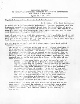
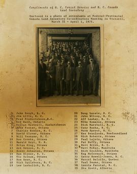
Photograph is a group portrait of the attendees at the Federal-Provincial Canada Land Inventory Coordinators Meeting in Victoria, March 31-April 1, 1971. Starting from the back row, left to right, attendees included: John Senyk, B.C.; Jim Allin, B.C.; Fred Frederickson, B.C.; Red Ward, Ontario; George Rathwell, Saskatchewan; John Foster, Ottawa, Charlie Rowles, B.C.; David Glover, Ottawa; Bill Yeomans, B.C.; Don Coombs, Ottawa; Harold Hoyt, N.B.; Brian King, Ottawa; Art Benson, B.C.; Scott Johnston, Ottawa; Dan Blower, B.C.; Vic Solman, Ottawa; Don Benn, B.C.; Dick Spilsbury, B.C.; Les Lavkulich, B.C.; Doug Lacate, B.C.; John Wilcox, B.C.; Alf Leahey, B.C.; Mike Romaine, Ottawa; Dick Marshall, B.C.; Gary Runka, B.C.; Norm Sprout, B.C.; Ken Beanlands, Newfoundland; Mick Roberts, Ottawa; Paul Lajoie, Ottawa; Pat Duffy, Ottawa; Bert Brink, B.C.; Merv McKay, Manitoba; Rich Goulden, Manitoba; Reg McCormack, Ottawa; Gerry Howell-Jones, B.C.; Marcel Belzile, Quebec; Paul Deane, Ottawa; Laurie Farstad, B.C.; Stu Scott, Alberta.
This remote-sensing aerial photograph was taken by Lockwood Survey Corporation Ltd. under contract for the B.C. Forest Service. This historically important aerial photograph depicts the W.A.C. Bennett Dam and Williston Reservoir soon after its flooding in 1968.
The identification coding on these photographs can be interpreted as follows:
- The largest number on the leftmost side is the frame number for the photograph.
- The following code to the right in the format B) 69-53 is currently unknown, but may refer to an internal project number for the Lockwood Survey Corporation.
- The 6" may refer to the camera's focal length in inches.
- Next is "17,150 ASL" which is 17,150 feet Above Sea Level.
- Following is "152.52" which refers to the camera's focal length in millimeters, which equals 6 inches.
- The "W1307" may refer to the reel, but that is unconfirmed.
- "8 SEP 69" is the date the photo was taken.
This remote-sensing aerial photograph was taken by Lockwood Survey Corporation Ltd. under contract for the B.C. Forest Service. This historically important aerial photograph depicts the headwaters of Williston Reservoir soon after its creation in 1968 with the building of the W.A.C. Bennett Dam on the Peace River.
The identification coding on these photographs can be interpreted as follows:
- The largest number on the leftmost side is the frame number for the photograph.
- The following code to the right in the format B) 69-53 is currently unknown, but may refer to an internal project number for the Lockwood Survey Corporation.
- The 6" may refer to the camera's focal length in inches.
- Next is "17,150 ASL" which is 17,150 feet Above Sea Level.
- Following is "152.52" which refers to the camera's focal length in millimeters, which equals 6 inches.
- The "W1307" may refer to the reel, but that is unconfirmed.
- "8 SEP 69" is the date the photo was taken.
Photograph depicts (from left to right) Philip Monckton, Gordon Wyness, and Lavender Monckton at the Beaverly Geodetic Station, 7 miles west of Prince George. Surveying equipment (tripod, theodolite, and wire) are stationed at centre.
Photograph depicts Phil B working underground.
File consists of research material regarding Pacific Great Eastern Railway and BC Rail Dease Lake extension. Predominantly consists of photocopy reproductions, excerpts from books, and clippings from periodicals. Includes the following works: "PGE/BCR: Dease Lake Extension - First 25 Years, 1968 to 1993"; PGE/BCR Dease Lake Branch Progress at end of 1974; "Dease Lake or Bust: BC Rail's Takla Sub, a Socred Mega-Project, Lives On" by Johnson; and "To Alaska or Bust on a Mixed Train: Was BCR's Dease Lake line too late...or too early?" by Patterson and McMillan. Also includes a map of the Dease Lake extension annotated by Davies.
Photo depicts the interchange of passengers of a northbound dayliner around the wreckage of a derailment. Two budd car units from Vancouver can been seen in the background. Passengers were being transferred to a "scratch" train assembled at Lillooet and consisting of a budd car, caboose and a diesal switcher.
Photo depicts the transfer of a Vancouveer to Lillooet dayliner to the unit made up at Lillooet wich consisted of a budd car, caboose and switcher. The scene of the Seton Portage derailment was found 100 yards behind the photo.
Photo depicts the largest crane on the Pacific Great Eastern and is stationed in Prince George.
Photo depicts a crane #6501 in position to lift locomotive #703. It was about to re-rail one end of the locomotive. Image captured looking towards the south with the shoo-fly in the immediate foreground and Setan Lake in the background.
Photo depicts a distant view of the Seton Portage wreck,. Squamish Shops crane was standing on the minor line of the loop. The crane was self-propelled and after its launch it had broken its drive axle. This was replaced by a standard axle and, therefore, was propelled by a switcher.
Photo depicts a close up view of the rear of the locomotive #703. It was stopped at the head of a freight onn the main line portion of the loop awaiting a southbound loaded freight. Its tracks were derailed, fuel tranks ruptures and a sliver of steel from the box car was forced into its forward tracks. The left side of the cab was also sheared.
Photo depicts the general view of a derailment, looking eastward. The derailed locomotive #703 was found beside a squashed box car. By this time, a PGE bulldozer had prepared a road bed for the wreck.
Photo depicts a shoo-fly that had been built around the Seton Portage wreck. locomotive #703 had stood at this spot just before the switch when the cars of the southbound freight piled into it.