Item is a photocopied map depicting the Cariboo district of British Columbia, in the vicinity of Summit Lake and the Salmon River.
File consists notes, correspondence, summary reports, inventory data, and a map regarding capability classification for Bowser Lake. The map is a "clean copy" of Grant Hazelwood's ungulate biophysical map without symbols. Summary reports include:
- Grant Hazelwood, "Ungulate Capability Classification"
- Grant Hazelwood, "Winter Flights, February 1986"
- "Ungulate Biophysical Mapping in the Stikine-Iskut Area"
File consists of correspondence regarding the Forest Health Development Plan and maps from Canfor Forest Products Ltd. (Canfor).
Map issued as part of the Canadian Pulp and Paper Industry magazine. Depicts locations of all pulp and paper mills in Canada in 1975 and provides a listing of company names.
Zimmerman, AdamMap depicts passenger routes on the Canadian Pacific Railway and its connecting lines in 1925.
The item is a map that depicts Canadian National Railway plans along Hammond street and the Fraser River. Includes the railway property, private property, proposed streets, and government owned property in the Prince George area.
The Canadian National Railway series consists of administrative records, safety records, correspondence between departments, labour records, records pertaining to train movements, maintenance records, and ephemera. Includes publications concerning the topics of unionized labour, railway operation, maintenance of way, handling of hazardous materials, safety, public interest, and the two Royal Tours of 1939 and 1959. Also consists of maps and technical drawings depicting Canadian National Rail lines and equipment.
Canadian National RailwayMap depicts the CNR system in Canada and the United States and all of its connecting lines, including the Central Vermont Railway, the Grand Trunk Western Railroad, and the Duluth Winnipeg & Pacific Railway.
Map depicts the Canadian National Railway system, including trackage for the Central Vermont Railway, the Detroit & Toledo Shore Line Railroad, the Grand Trunk Western Railroad, the Duluth Winnipeg & Pacific Railway, and the Northern Alberta Railway.
Map depicts the shipping highway routes across Canada. Primary, secondary, and access routes are noted as-well as proposed routes.
Map depicts Canadian railways in operation at 2011.
Map depicts the jurisdictions of the various Indian treaties in existence in 1966, including the boundaries of: no surrenders, exempted-royal proclamation, no valid surrenders, land and hunting rights surrenders, and land surrender only. The whole of Canada is depicted in this map.
Map depicts to Canadian federal electoral districts for the 1993 federal election.
Map depicts the Coast of British Columbia and Federal and Provincial proposed fishing boundaries, including the 200 mile limit.
Item is an original 1968 map depicting British Columbia and its reliefs, including hills, valleys, and mountains across the province. The map was published by the British Columbia Department of Lands, Forests and Water Resources.
Map depicts railways in British Columbia, with insets for the Lower Mainland and the Kootenays.
Government map depicts railway lands, lands "disposed of", grazing leases, and timber berths. Shows the British Columbia 'railway belt' running from Greater Vancouver to Field, B.C.
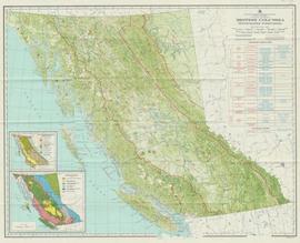
Item is a map compiled and produced by Geographic Division, Surveys and Mapping Branch, Department of Lands, Forests, and Water Resources ; geological and physiographical data supplied by Dept. of Mines and Petroleum Resources, Victoria, B.C. (1964).
The map depicts the highest mountains in British Columbia; includes the Rocky Mountains, the Northern and Southern Plateaus, and the Mackenzie Mountain area.
Map depicts annotations of the freight-way routes throughout British Columbia. These routes include: the Garnet Enterprise Truck Haul from Vancouver to Terrace, the Canadian Freightways from Vancouver to Edmonton to Alaska; the Lindsay Transfer from Terrace to Dease Lake and Telegraph Creek; and the Northland Navigation roll-on and roll-off service.
Map depicts the climactic regions of British Columbia which includes the coast, interior, and the northwest.
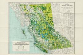
The map depicts the biotic regions and forests in British Columbia.
Item is an original map depicting British Columbia published by the National Atlas Information Geographical Services Division.
Item is an original 1970 map of British Columbia with annotations of Kent's travels throughout the province highlighted in yellow. The map was originally published by the Department of Lands, Forests and Water Resources in British Columbia.
Item is a map of British Columbia and is a key map showing: maps published on scale 1 inch to 2 miles and summary zones of the provincial forest inventory. Map includes index of post offices correct to October 22, 1956.
Item is an original 1982 map depicting the Bowron River in British Columbia, published by the Province of British Columbia Ministry of Environment.
The item is a map depicting Bowron Lake Park in British Columbia, the park boundary, the patrol cabin, roads, campsites, glaciers, and trails. Various handwritten annotations are written on the map and Public Shelters are circled in red pen.
Item is an original 1980 map depicting Bonaparte Lake in British Columbia, published by the Department of Energy, Mines and Resources in Ottawa.
Item is an original 1969 map depicting Bonaparte Lake in British Columbia, published by the Department of Energy, Mines and Resources in Ottawa Canada.
Item is a hand drawn and coloured map by the City of Prince George Planning Department depicting the Blackburn neighbourhood development area's proposed sector plan in 1976.
Item is an original map depicting biogeoclimatic zones of British Columbia published by the Ministry of Forests in Victoria, British Columbia.
Item is an original map depicting biogeoclimatic units of the Prince George Forest Region published by the British Columbia Ministry of Forests.
Item is an original 1989 map depicting Bella Coola in British Columbia, published by the Department of Energy Mines and Resources in Ottawa, Canada. The map also includes Kent Sedgwick's travels in the Bella Coola area highlighted in red.
Map depicts British Columbia in its entirety as-well as smaller subsequent maps of Vancouver, Victoria and Vicinity, Prince George, Kamloops, Nelson, and Vancouver Island.
Map depicts sea floor of the Beaufort Sea, fault lines, and diapirs.
The item is a reproduction of an aerial photograph of Prince George. Annotation states, "City of Pr. Geo. 1958 Aereal Photo CBD."
The item is a reproduction of an aerial photograph of Prince George between 1972 to 1975.
This map depicts where to find ghost towns, forts, First Nation villages, and sites with supposed hidden treasures in British Columbia.
Item is a British Columbia Forest Cover Map, serial number 093J010. Includes full format forest cover labels.
Item is a British Columbia Forest Cover Map, serial number 093J010. Includes full format forest cover labels.
Item is a British Columbia Forest Cover Map, serial number 093I001. Includes full format forest cover labels.
Subseries contains material collected and created by Kent Sedgwick for research on various areas in British Columbia and Alberta. Includes written notes by Kent Sedgwick, pamphlets, and newspaper clippings relating to towns and settlements. These areas include Quesnel, Likely, the Yukon Telegraph Trail, Barkerville, Wells, the Cariboo region, Fort Alexandria, Soda Creek, the Chilcotin region, Jasper, the Rocky Mountains, Mackenzie, Tumbler Ridge, the Peace River region, Fort St. James, the Omineca region, Kitimat, Lethbridge, the Bulkley Valley, and Fort Mcleod. These files cover a variety of topics including Chinese people in British Columbia, land settlement, tourism, and historic information on the regions.
Series consists of records created and collected by Gary Runka during and after his time with the British Columbia Agricultural Land Commission. In the early 1970s, Runka served as the first general manager of the BC Agricultural Land Commission, the independent provincial body that has administered BC's Agricultural Land Reserve (ALR) for over 40 years. As the first manager, Runka spearheaded the establishment of the ALR undertaking the technical tasks of setting ALR agricultural use boundaries, policies and procedures, as well as the building awareness and support for farmland preservation within government and with the public. He later served as Commission chair. Records include correspondence, informational material, publications, clippings, news releases, memoranda, symposium/conference material, reports, speech notes, and other textual material. Also includes seven maps, two buttons, six floppies, eighty slides, and one audio cassette tape.
Item is an original map depicting the Bateman forestry route. Map includes pen markings.
Item is an original 1983 map depicting Atnarko River in British Columbia, published by the Province of British Columbia Ministry of Environment.


