Item is a British Columbia Forest Cover Map, serial number 093J010. Includes full format forest cover labels.
Item is a British Columbia Forest Cover Map, serial number 093J010. Includes full format forest cover labels.
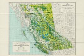
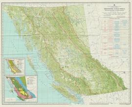
Item is a map of British Columbia and is a key map showing: maps published on scale 1 inch to 2 miles and summary zones of the provincial forest inventory. Map includes index of post offices correct to October 22, 1956.
Item is a map compiled and produced by Geographic Division, Surveys and Mapping Branch, Department of Lands, Forests, and Water Resources ; geological and physiographical data supplied by Dept. of Mines and Petroleum Resources, Victoria, B.C. (1964).
Map issued as part of the Canadian Pulp and Paper Industry magazine. Depicts locations of all pulp and paper mills in Canada in 1975 and provides a listing of company names.
Sans titreFile consists notes, correspondence, summary reports, inventory data, and a map regarding capability classification for Bowser Lake. The map is a "clean copy" of Grant Hazelwood's ungulate biophysical map without symbols. Summary reports include:
- Grant Hazelwood, "Ungulate Capability Classification"
- Grant Hazelwood, "Winter Flights, February 1986"
- "Ungulate Biophysical Mapping in the Stikine-Iskut Area"
A set of 13 maps showing approximate waste extraction areas for different benches during certain months of 1972. Extraction dates are included accompanied by estimated total tonnages for each planned extraction area. All plans are hand drawn using colored pencils, lead and black ink. Approximate calculations of extraction tonnages are included within certain months. Numerical bench markers are included. Total tonnages from the previous year and previous surveys are included within certain plans.
Fonds consists of textual, photographic, cartographic, electronic and promotional films/video recordings related to the mining operations of Cassiar Asbestos Mining Corporation (CAMC) and creation of Cassiar townsite. CAMC records primarily consist of records related to mining operations including construction, engineering, daily mining operations, administration of CAMC, tallies of extractions, labour and union activities, corporate events and visits by dignitaries. Townsite records are primarily visual representations of townsite construction, including the creation of health, education and community services including Cassiar's private hospital, school, library, as well as townsite images. Photographs include documentation of natural and man-made landscapes within the Cassiar region of Northern BC. Other holdings include a near complete run of Cassiar's community newspaper.
Sans titreOriginal linen map depicts mining claims in the Cassiar District of British Columbia that were located in 1900-1901: L. 115 Princess Louise, L. 310 North Star, L. 311 Bonanza, L. 309 Emerald, and L. 312 Emma.
File consists of documentation for various field sites. File also includes Harry Coates employment contracts (restricted). File also includes a Forest Cover Map Series 93H.093 1998-JUN-02 010, produced by the inventory branch of the Ministry of Forests, Province of British Columbia; Timber supply area: Prince George.
Fonds consists of documents providing information on the Columbia Cellulose Company, Limited covering the period of 1959-1970. These documents detail the company’s history, historical and geographical context, and plans for the future. Files often include photographs, maps, and technical drawings of the mills.
Sans titreSeries consists of documents providing information on the Columbia Cellulose Company, Limited including its history, historical and geographical context, and plans for the future. These documents often include photographs, maps, and technical drawings of the mills. Series consists of Skeena Kraft press kit; Feasibility Study of Nass River Valley Log Transport Systems; A Summary History and Progress; Development Study: Northern resources; Columbia Cellulose Company, Limited.
Map reflects highways, main, branch and property roads, trails, public sustained yield unit boundaries, cutting permit boundary, contours, height of land, edge of lake, merchantable and immature timber, non-commercial cover, and swamps.
Item is a map of Prince George Wood Preserving Ltd. Development Plan Forest Licence A27771 for the period of January 1, 1986 to January 1, 1991: Fraser Operating Area. Geographic features include the Fraser River.
File consists of:
- "Development Study - Northern Resources" by the Columbia Cellulose Company, Limited, September, 1963. This report includes: background information on the company and a contextual background of forestry in British Columbia; a description of resources and proposed facilities, which covers northern wood resources and requirements for future sulphite and sulphate mills; an economic study for new Kraft operations.
- 2 maps: one of British Columbia entitled "Status of Sustained-Yield Forestry Programme as at 31 December 1962" by the Department of Lands, Forests, and Water Resources; the other of British Columbia Forest Service Forest: Surveys and Inventory Division, Key Map Showing: Maps published on scale 1 inch to 2 miles and summary zones of the provincial forest inventory by the Department of Lands and Forests (1957).
Map of Timber Sale X72108 shows area to be scarified. Location is outside Prince George in the Upper Fraser area near Kenneth Creek.
Map of Timber Sale X72108 shows area to be scarified. Location is outside Prince George in the Upper Fraser area near Kenneth Creek.
Map of Timber Sale X72108 shows area to be scarified, as well as previously logged areas. Location is outside Prince George in the Upper Fraser area near Kenneth Creek.
Fonds consists of the research records of Dr. Paul Sanborn, a University of Northern British Columbia faculty member in the Department of Ecosystem Science and Management.
Sans titreCollection consists of 1 map of "Status of Sustained-Yield Forestry Programme as at December 31, 1969" by British Columbia Department of Lands, Forests, and Water Resources and 10 pages of handwritten instructions for opening a ranger station in Smithers and annual Forest Insect and Disease Survey, dated 1980.
File consists of photocopied documentation for E.P. 646.3 Reciprocal Planting of Spruce Provenances in the Rocky Mountain Trench along with printed satellite maps from Bing Maps. File also includes a map of Buckhorn Barn showing reserve no. EP 505, research & R.N. projects. Map includes annotations for EP 646.3.
Item is a Forest Cover Map, 93J-10-d, annotation on the back reads Carpet Lake. Geographic features include Merton Lake and Peculiar Lake.
Item is a Forest Cover Map, 93J-7, annotation on the back reads Summit Lake. Geographical features include Summit Lake and Crooked River.
Original forest cover map shows timber history in the area of Giscome, BC.
Colour-coded topographic map depicts forest stands of different heights.
Series consists of records pertaining to Harry Coates work and training as a BC Forest Service Research Technician. Series includes documentation for various Sx trials and experimental plots (E.P.) Harry Coates worked on.
Map reflects soil and landforms of Giscome area.
Fonds consists of material created and collected by wildlife biologist Grant Hazelwood in relation to his work and research regarding wildlife, habitat, and wilderness parks. Includes material regarding Hazelwood's Tailed Frog (Ascaphus truei) research. Also includes records regarding his contracted biologist work via his consultancy business, Alpenglow Resources, on the BC Ministry of Environment's "Upper Nass Assessment Project", a project that included the biophysical mapping of the Northwest-Klappan Road Access Area.
Sans titreFonds consists of records Harry Coates created or received and retained during his career as a BC Forest Service Research Technician and into his retirement as a Sustainable Forest Management activist. Fonds includes materials from his work at the Aleza Lake Research Forest.
Sans titreSeries contains historical information regarding the Aleza Lake Research Forest. Includes photographs and slides pertaining to the Aleza Lake Experiment Station.
File consists of an original reproduction of a map entitled "Impact of Kemano Expansion on Gitksan-Wet'suwet'en Fishery". The map depicts salmon spawning areas, hydroelectric structures (Kenney Dam, Kemano powerhouse, etc), and Gitksan-Wet'suwet'en communities (Gitwangak, Kitseguecla, Gitanmaax, Hagwilget, Moricetown). Includes notable impacts and Indigenous place names for rivers, creeks, and lakes.
Map depicts the Kitlope range, Kimsquit Watershed, and area around Kitlope Lake. Includes Indigenous place names, grease trails, Indigenous village sites, and wildlife information.
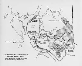
Item is a map showing the watersheds of Diana Lake, Rainbow Lake and Prudhomme Lake.
File contains various correspondence regarding 1964 annual cuts for sawmills in the area, memoranda consisting of various administrative issues such as the 1973 amalgamation of Purden Lake and Aleza Lake, and the sale of lumber previously infested by spruce beetles. File also contains 1972 applications to purchase Crown timber and road use, as well as 1966 logging permits.
Series contains working and management plans, a policy handbook, drafts, correspondence, proposals, recommendations, revenue records, photographs, handwritten notes, maps, and planning projects.
Item is a reproduced map of Aleza Lake annotated to show a 1994 RFP study area.
Item is a photocopied map of the Aleza Lake area annotated to show transects.
Item is a map that distinguishes the regions covered by Tree Farm Licence No. 1 granted to Columbia Cellulose and Three Farm Licence No. 40 granted to Skeena Kraft. Major locations indicated in this map include: Prince Rupert, Terrace, Hazelton, Smithers, Kitimat, Skeena River, and Nass River. Railway routes are also shown.
Map reflects reserve boundary, roads, trails, 20 feet contour intervals, air photo centre, declination, swamps, and mile post at the Aleza Lake Forest Reserve.
Series consists of cartographic materials including maps and blueprints of the Aleza Lake Research Forest. The maps reflect permanent sample plots and other study areas. The blueprints outline details for the development of a Ranger Station.


