Affichage de 408 résultats

Archival description
201 résultats avec objets numériques Afficher les résultats avec des objets numériques
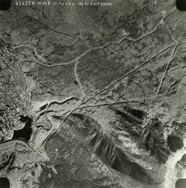
Photo 41407 - W.A.C. Bennett Dam
2019.10.4.41407 · Pièce · 8 Sept. 1969
Fait partie de Lockwood Survey Corporation Ltd. collection

This remote-sensing aerial photograph was taken by Lockwood Survey Corporation Ltd. under contract for the B.C. Forest Service. This historically important aerial photograph depicts the W.A.C. Bennett Dam and Williston Reservoir soon after its flooding in 1968.

The identification coding on these photographs can be interpreted as follows:

  • The largest number on the leftmost side is the frame number for the photograph.
  • The following code to the right in the format B) 69-53 is currently unknown, but may refer to an internal project number for the Lockwood Survey Corporation.
  • The 6" may refer to the camera's focal length in inches.
  • Next is "17,150 ASL" which is 17,150 feet Above Sea Level.
  • Following is "152.52" which refers to the camera's focal length in millimeters, which equals 6 inches.
  • The "W1307" may refer to the reel, but that is unconfirmed.
  • "8 SEP 69" is the date the photo was taken.
Pl. 721 DL 1426
2012.13.2.02.33.15 · Pièce · [1990?]
Fait partie de J. Kent Sedgwick fonds

The item is a reproduction of a survey map likely drafted in the 1910s. The reproduction was likely created in 1990. The area covered is South of Anderson Street, East of Simpson Street, North of Van Bien Avenue and West of 9th Street. Annotations state, "Pl 721 DL 1426."

2012.13.2.02.33.08 · Pièce · [1990?]
Fait partie de J. Kent Sedgwick fonds

The item is a reproduction of a survey map drafted in July 1914. The reproduction was likely created in 1990. The area covered is along the Fraser River and east of Guelph Street. Annotations state, "PL 1409 D. L. 417 HBCo." and highlight different scales of measurement and changed street names.

2012.13.2.02.33.12 · Pièce · [1990?]
Fait partie de J. Kent Sedgwick fonds

The item is a reproduction of a survey map drafted on 29 Oct. 1910. The reproduction was likely created in 1990. The area covered is South of Princess Street, East of James Avenue, North of 8th Street and West of Rupert Avenue. Annotations state, "Jesse Hodgeson Crown grand in 1910 for $800..."

2012.13.2.02.33.09 · Pièce · [1990?]
Fait partie de J. Kent Sedgwick fonds

The item is a reproduction of a survey map drafted in 1 Oct. 1913. The reproduction was likely created in 1990. The area covered is along the Fraser River and west of Linooln Avenue, south of Jackson Street and North of McKinley Street. Annotations state which maps and lots are adjacent to this one. An illegible signature is highlighted.

2012.13.2.02.33.16 · Pièce · [1990?]
Fait partie de J. Kent Sedgwick fonds

The item is a reproduction of a survey map drafted on 1 March 1910. The reproduction was likely created in 1990. The area covered is South of Bernhardt Avenue, East of Simpson Street, North of the Fraser River and West of 9th Street. Annotations state, "DL 1426 Plan 721."

2012.13.2.02.33.03 · Pièce · [1990?]
Fait partie de J. Kent Sedgwick fonds

The item is a reproduction of a survey map drafted on 1 March 1910. The reproduction was likely created in 1990. The area highlighted is along the Fraser River. The map details subdivisions East of Ninth Street and South of Thapage Lane. Land Surveyor J. F. Templeton certified the plan. Annotation on the map states, "Pl. 727."

2012.13.2.02.33.13 · Pièce · [1990?]
Fait partie de J. Kent Sedgwick fonds

The item is a reproduction of a survey map likely drafted in the 1910s. The reproduction was likely created in 1990. The area covered is South of Baillie Street, East of 22nd Avenue, North of Princess Street and West of 7th Avenue. Annotations state, "Pl. 833" and various lot descriptions.

"Plan of subdivision of part of lot 925"
2012.13.3.1.01.1 · Pièce · [between 1980 and 2000]
Fait partie de J. Kent Sedgwick fonds

The map depicts Prince George lots alongside the Fraser River and has annotations by Kent Sedgwick outlining the location of the original cemetery. The map is a reproduction created in August 1910 and revised in 1965. Copy was produced between 1980 and 2000.

2012.13.2.02.33.14 · Pièce · [1990?]
Fait partie de J. Kent Sedgwick fonds

The item is a reproduction of a survey map drafted on 27 July 1910. The reproduction was likely created in 1990. The area covered is South of Reserve Avenue, East of Victoria, North of Bird Avenue and West of 9th Street. Annotations state, "#796" and highlight the date and registered owner.

2012.13.2.04.02.1 · Pièce · [between 1990 and 2005]
Fait partie de J. Kent Sedgwick fonds

The item is a reproduction of a map originally surveyed in 1984 by F. A. Deveraux. The map is a plan of the "Fort George Indian Reserves" in the Cariboo District. Annotations include the approved signatures of Leo. B. Martin and R. O'Reilly dated 21 September 1895.

"Prince George B.C."
2012.13.2.21.08.1 · Pièce · 26 Apr. 1967
Fait partie de J. Kent Sedgwick fonds

This very large drawing shows CN leases and private property buildings on Island Cache in detail.

Sans titre
Regional District of Kitimat-Stikine
2009.6.13.45.18 · Pièce · 1976
Fait partie de The Honourable Iona Campagnolo fonds

Map depicts the regional district of Kitmat, but is extensively annotated showing the proposed route of the Kitmat Truck Ferry, running through Terrace and up into the "Yukon Markets," and the Kispiox Connector, running from Prince Rupert to Hazelton and further East along Highway 16 and north along the Kispiox River.

2001.1.086 · Pièce · 2 Sept. 1943
Fait partie de NBCA Document and Ephemera Collection

Pennock, W.B. RIVER CROSSING EXERCISE. Prince George, B.C. 2 SEP 43. Presented to Major-General H.N. Ganong G.O.C. 8 CDN. DIV. by Lt-Col. W.B. Pennock C.R.C.E. 8 CDN. DIV. 1943. Oblong 4to. 24pp of text, color maps, one showing the proposed crossing of Nechako River. 20 b/w snapshot photos, mounted with corners, each with captions + Appendix A, B and C of facts and figures. A large folding contemporary map of Vernon is laid in, with one of the training zones (?) highlighted on the map in a red square box. Fabricoid spine and corners.

The original typescript for a (presumably confidential and secret) document listing the preparations for defensive manoeuvres in the event of war with Japan taking place in Northern British Columbia. This document describes a simulation of what events and defences could take place, including how to conduct river crossings; when in the war game, the author imagines what would happen should the Japanese invade Prince Rupert as a starting point for the invasion of Canada.

An important document providing insight into the thinking of the Canadian military while preparing for the possibility of Japan extending its war into the North Pacific Theatre during World War II.

Salmon Portage area, map 93J.026
2012.13.4.09.5 · Pièce · 1992
Fait partie de J. Kent Sedgwick fonds

The item is a map depicting the Salmon Portage area along the Salmon River. Various annotations are written in pen and sections of the map are coloured with pencil crayon. The Forest Cover Map identification number is 93J.026.

Salmon Portage area, map 93J.026
2012.13.4.09.1 · Pièce · 28 June 1999
Fait partie de J. Kent Sedgwick fonds

The item is a map depicting the Salmon Portage area along the Salmon River. Various annotations are written in pen and sections of the map are coloured with pencil crayon. The Forest Cover Map identification number is 93J.026.

Salmon Portage area, map 93J.027
2012.13.4.09.2 · Pièce · 28 June 1999
Fait partie de J. Kent Sedgwick fonds

The item is a map depicting the Salmon Portage area along the Salmon River. Various annotations are written in pen and sections of the map are coloured with pencil crayon. The Forest Cover Map identification number is 93J.027.

Salmon Portage area, map 93J.027
2012.13.4.09.3 · Pièce · 1991
Fait partie de J. Kent Sedgwick fonds

The item is a map depicting the Salmon Portage area along the Salmon River. Various annotations are written in pen and sections of the map are coloured with pencil crayon. The Forest Cover Map identification number is 93J.027.