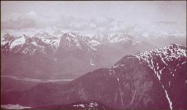
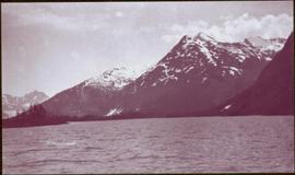
Geographic Features

Elements area

Taxonomy

Code

Scope note(s)

  • Includes both natural and artificial features

  • Physical landscape, built landscape

  • Urban and industrial landscapes

  • Topography

  • Site plans

  • Boundaries, districts, reserves, parks, sanctuaries, towns, etc.

  • NOTE: Mainly but not exclusively pertaining to photographic and cartographic records

  • SEE ALSO: Land, Settlement and Immigration

Source note(s)

  • MemoryBC Subject Groups

Display note(s)

    Hierarchical terms

    Geographic Features

      Equivalent terms

      Geographic Features

        Associated terms

        Geographic Features

          4 Archival description results for Geographic Features

          4 results directly related Exclude narrower terms
          McKee Creek, BC
          2009.5.2.81 · Item · 27 June 1937
          Part of Taylor-Baxter Family Photograph Collection

          Photograph depicts dry creek bed, tall banks on either side. Hills and lake cross midground, mountains visible in background. Handwritten annotation on verso of photograph: "Looking down McKee Creek across Atlin Lake Towards Taku Glacier 6/27/37."

          2006.20.3.51 · Item · [between 23 May 1906 and 15 October 1906]
          Part of Northern BC Archives Historical Photograph Collection

          Photograph depicts river or glacier in valley bellow mountains. Handwritten annotation visible on negative: "From No. 2 Cam. Sta. [?] Taku River [?]".

          Image is one of 65 photos documenting a survey of the Canada-Alaska Boundary, Taku River area, May 23 to Oct. 15, 1906. This particular photo is one of 10 found in original enclosure with the following handwritten annotation: "From [Wahut?]-Azmuth and Koshu.” See also items 2006.20.3.47 - 2006.20.3.56.

          2006.20.3.52 · Item · [between 23 May 1906 and 15 October 1906]
          Part of Northern BC Archives Historical Photograph Collection

          Water spans foreground, mountains of opposite shore stand in background.

          Image is one of 65 photos documenting a survey of the Canada-Alaska Boundary, Taku River area, May 23 to Oct. 15, 1906. This particular photo is one of 10 found in original enclosure with the following handwritten annotation: "From [Wahut?]-Azmuth and Koshu.” See also items 2006.20.3.47 - 2006.20.3.56.