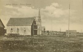
Geographic Features

Elements area

Taxonomy

Scope note(s)

  • Includes both natural and artificial features

  • Physical landscape, built landscape

  • Urban and industrial landscapes

  • Topography

  • Site plans

  • Boundaries, districts, reserves, parks, sanctuaries, towns, etc.

  • NOTE: Mainly but not exclusively pertaining to photographic

  • Read more

Source note(s)

  • MemoryBC Subject Groups

32 Archival description results for Geographic Features

32 results directly related Exclude narrower terms
2006.20.11.2 · Item · [ca. 1900]
Part of Northern BC Archives Historical Photograph Collection

Photograph depicts a street scene along Second St. in Fort George. Wagons line the dirt road which is flanked by wooden buildings. A group of unidentified men stand on the boardwalk outside of Rigg's Restaurant. Handwritten annotation along bottom ofRead more

Prince George to Tete Jaune
2011.3.4.14 · Item · [ca. 1901-1915]
Part of North Coast & Central BC Postcard Collection

Stern wheeler in river. Handwritten annotation in pencil on verso reads: “Prince George to Tete Jaune” Hand written message in ink on verso is addressed to “Mademoiselle Elisabeth Joliet, Terrguy – Les Dijore Cote a Or France”

2010.13 · Collection · 1910 - [ca. 1950]

Collection contains photographs depicting community life in Prince George, B.C. Images depict holiday events, sports teams, government buildings, businesses (hotels, banks, retail, newspaper office), riverboats, railroad construction, fishing, a cemetery,Read more

2008.2.002 · Item · 1916
Part of NBCA Cartographic Collection

Colour-coded map depicting lands open for pre-emption, lands in “University Reserve,” and lands reserved for public auction. Depicts land recording divisions, communities, bodies of water, transport routes, and game reserves.

2008.2.008 · Item · 15 February 1923
Part of NBCA Cartographic Collection

Colour-coded map depicting lands surveyed as alienated, reserved, Statutory Timber Lands, B.C. Land Settlement Board Area, or open for pre-emption. Depicts land districts, land recording divisions, communities, game reserves, bodies of water, transportRead more

Plans and Legal Records
2002.17.2 · Series · 1913-1914
Part of Henderson-Roe collection

Consists of legal records and documents related to the holdings and activities of J. B. Henderson-Roe and his father, C.H. Henderson-Roe, including a hand-drawn map of Prince George, Fort George, and South Fort George, as well as a surveyor's plan for a subdivision.

2011.3 · Collection · 1901 - [ca.1930]

A collection of postcard photographs of Port Essington BC, Port Simpson BC, Atlin, Quesnel, McBride, Hagwilget Village, Giscome, Likely, Kitwanga, Smithers, Prince Rupert BC, Prince (Fort) George BC Images depict street scenes, water scenes, communityRead more

2006.20.9.24 · Item · [ca. 1897 - 1960]
Part of Northern BC Archives Historical Photograph Collection

View of a scow loaded with provisions and several people passing through rapids of the Grand Canyon. Printed annotation on recto reads: “A scow loaded with provisions passing through the Grand Canyon on it’s way to Fort George.” Handwritten annotation inRead more

2002.17.6 · Item · 3 July 1912
Part of Henderson-Roe collection

Map is entitled "Latest Map of Fort George District" and published 1912. Includes Peace River Recording Land District, Fort George Land Recording District, and Cariboo Land Recording District. Several sections are marked with red pencil.

2009.5.3.28 · Item · [ca. 1912]
Part of Taylor-Baxter Family Photograph Collection

Photograph depicts the early settlement of Fort George. The buildings to the left of the fence are believed to be owned by the Hudson's Bay Company. The land to the right of the fence belonged to the Fort George Reserve, the home of today's Lheidli T'Read more

Fort George
2008.2.027 · Item · 1 May 1949
Part of NBCA Cartographic Collection

Colour-coded map depicts surveyed lands alienated, available for purchase or lease under Land Act, or available for pre-emption. Depicts land districts, land recording districts, provincial forests, parks, game reserves, communities, bodies of water,Read more

Fort George
2008.2.024 · Item · 3 January 1944
Part of NBCA Cartographic Collection

Colour-coded map depicting surveyed lands alienated, available for purchase or lease under Land Act, and available for pre-emption. Depicts land districts, land recording districts, provincial forests, parks, game reserves, communities, bodies of water,Read more

2006.20.11.3 · Item · [ca. 1900]
Part of Northern BC Archives Historical Photograph Collection

Photograph depicts a street scent at the corner of Laselle and Second St. in Fort George. A wagon is visible in the dirt road and wooden buildings cross the mid ground. Three unidentified men sit on the boardwalk outside Rigg's Restaurant while one manRead more

2011.3.2.09 · Item · 1913
Part of North Coast & Central BC Postcard Collection

Printed annotation on recto reads: “Central Avenue Fort George B.C. Copyright Canada June 25th 1913”. Handwritten annotation in ink on recto reads: “Hotel Fort George; Pool room; Men’s furnishing; General store; Bank Vancouver; Telephone office;Read more

2006.20.9.6 · Item · 19 October 1911
Part of Northern BC Archives Historical Photograph Collection

Photograph depicts two, four-horse stagecoaches laden with passengers parked outside the Hotel Northern in South Fort George. A group comprised of primarily men watch the stagecoaches from the veranda of the hotel. Handwritten annotation in bottom rightRead more

Bridge Near Burns Lake, BC
2009.5.1.90 · Item · [ca. 1915]
Part of Taylor-Baxter Family Photograph Collection

Photograph depicts a log bridge interrupting a wide dirt road in forest. Distant hills in background. Image has been cropped to an oval shape. Handwritten annotation on verso of photograph: "Fort George - Hazleton Highway Near Burn's Lake".

2006.20.9.28 · Item · ca. 1954
Part of Northern BC Archives Historical Photograph Collection

Postcard featuring a photograph of a photograph of the arrival of the first stage coach at the Hotel Northern in South Fort George, BC on 19 October 1911. Handwritten annotation on recto of photograph reads: “Arrival of first stage at So. Ft. George B.C.Read more