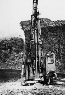
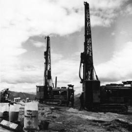
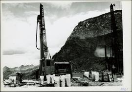
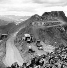
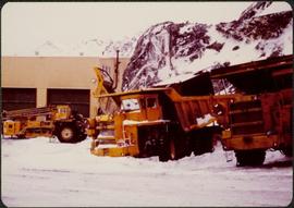
Geographic Features

Elements area

Taxonomy

Scope note(s)

  • Includes both natural and artificial features

  • Physical landscape, built landscape

  • Urban and industrial landscapes

  • Topography

  • Site plans

  • Boundaries, districts, reserves, parks, sanctuaries, towns, etc.

  • NOTE: Mainly but not exclusively pertaining to photographic

  • Read more

Source note(s)

  • MemoryBC Subject Groups

167 Archival description results for Geographic Features

167 results directly related Exclude narrower terms
1961 - 6430 Ore Bench
2000.1.1.3.19.002 · Item · July 1961
Part of Cassiar Asbestos Corporation Ltd. fonds

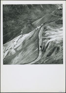
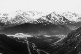
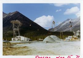
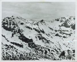
Photograph depicts bench at 6430 elevation. Blasthole drills, shovels, dozers, and dump trucks can be seen on bench in midground. Mine valley in background. Handwritten annotation on verso of photograph: "1961".

1961 - Bar & Snackbar
2000.1.1.3.19.031 · Item · 1961
Part of Cassiar Asbestos Corporation Ltd. fonds

Photograph depicts long wood building believed to be the bar and snackbar at Cassiar B.C. Two men can be seen standing on one of three porches to building. Pole, car, and trees in foreground; unknown buildings and mountain base in background. HandwrittenRead more

2000.1.1.3.19.001 · Item · July 1961
Part of Cassiar Asbestos Corporation Ltd. fonds

Photograph depicts mine area at Cassiar, crushing plant visible on left. Various mine buildings visible midground. Blasthole drills, shovels, dozers, and dump trucks can be seen on bench in foreground at 6430 elevation. Handwritten annotations on rectoRead more

1961 - Community Centre
2000.1.1.3.19.030 · Item · 1961
Part of Cassiar Asbestos Corporation Ltd. fonds

Photograph depicts long wood building speculated to be the Community Centre at Cassiar, B.C. Sports net stands in right foreground. Flag pole, barrel, and stand of trees can be seen in front of building. Mountains in background. Handwritten annotation onRead more

2000.1.1.3.19.007 · Item · 1961
Part of Cassiar Asbestos Corporation Ltd. fonds

Photograph depicts an Atlas Copco Drillmaster (blasthole drill) near the mine road, mountainside in background. This is a precision hammer drill which had its own power source. It is believed that this photo was taken on the North ridge, near the cirqueRead more

2000.1.1.3.19.005 · Item · 1961
Part of Cassiar Asbestos Corporation Ltd. fonds

Photograph depicts men standing near two Atlas Copco Drillmasters (blasthole drills). These are precision hammer drills which had their own power source. Large bags of ammonium nitrate in foreground, mountaintops in background. The men depicted here wereRead more

2000.1.1.3.19.006 · Item · 1961
Part of Cassiar Asbestos Corporation Ltd. fonds

Photograph depicts men standing near two Atlas Copco Drillmasters (blasthole drills). These are precision hammer drills which had their own power source. Large bags of ammonium nitrate in foreground, mountainside in background. The men depicted here wereRead more

1961 - Explosive Preparation
2000.1.1.3.19.009 · Item · 1961
Part of Cassiar Asbestos Corporation Ltd. fonds

Photograph depicts a man wearing a hard hat preparing long narrow bags of explosive material. Large bags of ammonium nitrate in right foreground, mountains in background. Handwritten annotation on verso of photograph: "1961".

1961 - Explosive Preparation
2000.1.1.3.19.010 · Item · 1961
Part of Cassiar Asbestos Corporation Ltd. fonds

Photograph depicts a man wearing a hard hat preparing long narrow bags of explosive material. Large bags of ammonium nitrate in right foreground, mountains in background. Handwritten annotation on verso of photograph: "1961".

1961 - Explosive Preparation
2000.1.1.3.19.008 · Item · 1961
Part of Cassiar Asbestos Corporation Ltd. fonds

Photograph depicts a man wearing a hard hat preparing explosive material, mountains in background. Dog stands near edge in midground, large bags of Ammonium Nitrate in right foreground. Handwritten annotation on verso of photograph: "1961".

1961 - Mine Buildings
2000.1.1.3.19.003 · Item · 1961
Part of Cassiar Asbestos Corporation Ltd. fonds

Photograph depicts buildings at various locations in mine: crushing plant (centre?) and what is believed to be the original tramline loading station on left. Mine road featured in center, blasthole drill visible near dump truck in midground. Mine valleyRead more

1961 - Mine Garage
2000.1.1.3.19.004 · Item · 1961
Part of Cassiar Asbestos Corporation Ltd. fonds

Photograph depicts a car and two dump trucks near a small garage by road in mine. One man stands at garage site among tires and miscellaneous tools. Blasthole drills, shovels, and dump trucks visible in distance. Rocks in foreground, mountains inRead more

1961 - Plantsite
2000.1.1.3.19.016 · Item · 1961
Part of Cassiar Asbestos Corporation Ltd. fonds

Photograph depicts various buildings in plantsite, vehicles and electricity lines throughout. Equipment garage stands in left background behind tank farm, carpenter shop in right background, machine and electrical shop in building semi-visible on farRead more

1961 - Power House
2000.1.1.3.19.017 · Item · 1961
Part of Cassiar Asbestos Corporation Ltd. fonds

Photograph depicts a large shelter over building believed to be power house. Electricity lines cross midground and run to power house. A man can be seen crossing the foreground by steel frame supplies, and a second building is partially visible on right.Read more

1961 - Shovel on Peak
2000.1.1.3.19.012 · Item · 1961
Part of Cassiar Asbestos Corporation Ltd. fonds

Photograph depicts a crawler cable shovel on right, and bulldozer partially visible on left. Rock face of mountainside in background. Handwritten annotation on verso of photograph: "1961", on recto: "Mining 80 D shovel on [?] 64/70 to 6560 saddle on peak."

1961 - Tramline & Plantsite
2000.1.1.3.19.015 · Item · 1961
Part of Cassiar Asbestos Corporation Ltd. fonds

Photograph depicts tower and bucket tram in left foreground, plantsite in midground, mountains across valley in background. Dry rock storage building, mill, tailings pile, and many other buildings visible in plantsite. Handwritten annotation on verso of photograph: "1961".

2000.1.1.3.19.018 · Item · 1961
Part of Cassiar Asbestos Corporation Ltd. fonds

Photograph depicts a gravel road passing under crossing. Sign posted to pole reads "CAUTION TRAMLINE CROSSING CAUTION AVIOD PASSING UNDER MOVING BUCKETS". Garage stands in left midground, mountains in background. Handwritten annotation on verso of photograph: "1961".

2000.1.1.3.19.053 · Item · 1965
Part of Cassiar Asbestos Corporation Ltd. fonds

Photograph depicts men's ball game in foreground, spectators and cars visible behind backstop net. Bar and snackbar building in right midground, trees and mountain base in background. See item 2000.1.1.3.19.52 for information regarding bar and snackbar building.

1965 - Bar & Snackbar
2000.1.1.3.19.052 · Item · 1965
Part of Cassiar Asbestos Corporation Ltd. fonds

Photograph depicts building containing Cassiar's bar and snackbar, visible across ball field. This building originally housed school classrooms, movie theater, barber shop, and rec centre with three pool tables. Private liquor store originally located inRead more

1971 - Director's Lodge
2000.1.1.3.19.088 · Item · 15 June 1971
Part of Cassiar Asbestos Corporation Ltd. fonds

Photograph depicts two unidentified men on front deck of building behind trees. Road and car in foreground, mountains visible in background. Handwritten annotation on verso of photograph: "Directors Lodge Cassiar June 15 71". Building also known as "House 130".

1971 - Summer Bunkhouses
2000.1.1.3.19.084 · Item · 15 June 1971
Part of Cassiar Asbestos Corporation Ltd. fonds

Photograph depicts long bunkhouse buildings located between the Cassiar plant and townsite. They were originally used seasonally by university students, or by new employees on waiting lists for the more accommodating panabode "Winter Bunkhouses" (seeRead more

1971 - Tramline on Plantsite
2000.1.1.3.19.083 · Item · 15 June 1971
Part of Cassiar Asbestos Corporation Ltd. fonds

Photograph depicts tramline buckets and tower on plantsite. Vehicles, building materials, and unidentified buildings also visible on plantsite (including what appears to be a water tower). Mountains and valley in background. Handwritten annotation onRead more

2000.1.1.3.19.079 · Item · 15 June 1971
Part of Cassiar Asbestos Corporation Ltd. fonds

Photograph depicts flowing water believed to be Troutline Creek which ran south of Cassiar, B.C. Tailings pile and plant buildings visible behind forest in midground, northern mountain range in background. Handwritten annotation on verso of photograph: "Read more

2000.1.1.3.19.080 · Item · 15 June 1971
Part of Cassiar Asbestos Corporation Ltd. fonds

Photograph depicts flowing water believed to be Troutline Creek which ran south of Cassiar, B.C. Tailings pile and plant buildings visible behind forest in midground, northern mountain range in background. Handwritten annotation on verso of photograph: "Read more

1971 - Unknown Residence
2000.1.1.3.19.090 · Item · 15 June 1971
Part of Cassiar Asbestos Corporation Ltd. fonds

Photograph depicts brown and white building similar to the "Director's Lodge" at Cassiar, B.C. (see items 2000.1.1.3.19.88 and 2000.1.1.3.19.89). Station wagon parked in driveway behind short fence in foreground. Trees in foreground, forest and mountainsRead more

2000.1.2.1 · Item · February 1952
Part of Cassiar Asbestos Corporation Ltd. fonds

The topographic map shows mine and campsite holdings within the proposed mine site. Asbestos deposits, the tramline and water bodies, such as Troutline Creek, are also included.

Annotations include certain lot titles being crossed out as well as asRead more

2000.1.1.2.2.29 · Item · 1963
Part of Cassiar Asbestos Corporation Ltd. fonds

Handwritten caption beside this photo reads: "Elaborate barricades required due to amount of loose rock falling continuously". Three men work in area confined by barricades made of vertical metal rods and horizontal wood planks. Miscellaneous buildingRead more

2000.1.1.3.24.01 · Item · [ca. 1980]
Part of Cassiar Asbestos Corporation Ltd. fonds

Photograph depicts William (Bill) Storie at location known as Limestone Mountain, southwest of Cassiar, B.C. Photo features profile of Bill, hands in pocket, Cassiar valley and mountains in background. Storie was a renowned prospector in the Cassiar area,Read more

Cassiar - Stewart Highway
2006.20.9.25 · Item · [ca. 1897 - 1960]
Part of Northern BC Archives Historical Photograph Collection

View of snow capped mountains in the distance, vast rolling treed hills in mid ground and a gravel road in the foreground. Road sign indicating severe curve in road situated at the right of the gravel road. Handwritten annotation on verso in pen reads: “Read more

Community Album - Bunkhouse
2000.1.1.3.19.112 · Item · [ca. 1980]
Part of Cassiar Asbestos Corporation Ltd. fonds

Photograph depicts an unidentified man walking in front of orange and brown two-story building speculated to be bunkhouse residences. Second unknown individual can be seen unloading car in left foreground. Trees and mountains visible in background.

Community Album - Fire Hall
2000.1.1.3.19.120 · Item · [ca. 1980]
Part of Cassiar Asbestos Corporation Ltd. fonds

Photograph depicts two fire trucks semi-visible in garage with the sign "FIRE HALL". House and snowmobile can be seen in left midground, truck and power pole in right foreground. Mountains in background. Warning visible on front of trucks: "KEEP BACK 500m".