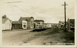
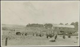
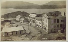
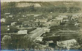
Geographic Features

Elements area

Taxonomy

Code

Scope note(s)

  • Includes both natural and artificial features

  • Physical landscape, built landscape

  • Urban and industrial landscapes

  • Topography

  • Site plans

  • Boundaries, districts, reserves, parks, sanctuaries, towns, etc.

  • NOTE: Mainly but not exclusively pertaining to photographic and cartographic records

  • SEE ALSO: Land, Settlement and Immigration

Source note(s)

  • MemoryBC Subject Groups

Display note(s)

    Hierarchical terms

    Geographic Features

      Equivalent terms

      Geographic Features

        Associated terms

        Geographic Features

          4130 Archival description results for Geographic Features

          4130 results directly related Exclude narrower terms
          2012.13.2.11 · Subseries · 1937-2011
          Part of J. Kent Sedgwick fonds

          Subseries consists of materials collected by Kent Sedgwick for research on the geography and natural resources in Prince George and its region. Includes material on the natural resource industry, including the opening of the McArthur Sawmill, the W. Lamb and Sons Lumber Sawmill, and mining; photocopied aerial photographs of Prince George; the climate, temperatures, and flooding; and the geographical features of Prince George.

          Geographic Features
          2006.20.11 · File · [ca. 1890 - 1940]
          Part of Northern BC Archives Historical Photograph Collection

          Photographs within this file document natural and artificial features across the landscape of Northern British Columbia. This landscape also includes the physical, built, urban and industrial landscapes; topography; site plans; boundaries, districts, reserves, parks, sanctuaries, towns, villages and cities, etc.

          2012.13.5.18 · File · 1978
          Part of J. Kent Sedgwick fonds

          File consists of notes and maps relating to the physical geography of the Central Interior and is background research for Geography Historical Geography of the Central Interior, a College of New Caledonia continuing studies course taught by Kent Sedgwick.

          General Operations Albums
          2000.1.1.3.19 · File · 1961 - [ca.1985]
          Part of Cassiar Asbestos Corporation Ltd. fonds

          File includes six aggregations of photographs which have been assembled in this file in order to maintain the integrity of each group by keeping the photos arranged together, though each group features operations pertaining to multiple files in this subseries. Includes groups featuring photos from 1961, 1965 1971, a helicopter trip, a community album, and a workplace album. Photographs depict images pertaining to the following operations at Cassiar, B.C.: mining, milling, maintenance, labratory tests, and tramline and town operations. Images featuring operations of the company town include the grocery store, bank, churches, school, library, lounge, pool, theater, community center, outdoor recreation, hospital, dentist, cafeteria, bus route, residences, air strip, firehall, laundromat, park, police, and newspaper.

          2000.1.1.3 · Subseries · [between 1952 and 1992]
          Part of Cassiar Asbestos Corporation Ltd. fonds

          Subseries consists of photographic material pertaining to the following subject areas: mine operations; plant operations;labour strike 1970s images; townsite operations of the company towns of Cassiar and Clinton Creek (including community activities associated therein and townsite development); as well as, images of mines not owned by Cassiar Asbestos Corporation, but which are believed to have been used for operational research purposes.

          Gang Ranch Sign
          2012.13.1.52.04 · Item · 1980
          Part of J. Kent Sedgwick fonds

          Image depicts the sign to Gang Ranch, located in the Upper Fraser Canyon, with graffiti on it.

          Gang Ranch - Fraser River
          2012.13.1.52.34 · Item · [1980?]
          Part of J. Kent Sedgwick fonds

          Image depicts the Fraser River, and a sign pointing towards Gang Ranch with an unknown individual hugging it, in the Upper Fraser Canyon.

          Gail and Sue Sedgwick
          2012.13.1.63.19 · Item · 1994
          Part of J. Kent Sedgwick fonds

          Image depicts two women sitting on a fallen tree on the shore of a lake, possibly Portage Lake; the woman in blue is "Gail," and the woman in red is Sue Sedgwick.

          Fur Trade
          2012.13.1.039 · Subseries · [between 1978 and 2008]
          Part of J. Kent Sedgwick fonds

          File contains slides depicting subjects related to the Fur Trade.

          2009.5.2.51 · Item · [ca. 1910?]
          Part of Taylor-Baxter Family Photograph Collection

          Photograph depicts two log buildings in fenced area on lake shore, forest trees in background. A man can be seen standing near docking area and small boat pier extending into water in foreground. Handwritten annotation on recto of photograph: "Fur Farm Red Rock Lake". This location is believed to at mile 27, north of Summit Lake.

          2009.7.1.063 · Item · [ca. 1873 - ca. 1920]
          Part of Archdeacon W. H. Collison fonds

          Photograph depicts a group of men, women, and children walking across beach towards water. Buildings visible on shore in left background.

          Handwritten annotation on verso reads: "Funeral party - en route to boat Metlakatla BC (Taking body over to Grave Island".

          2012.13.5.09 · File · 2004
          Part of J. Kent Sedgwick fonds

          File consists of notes, clippings, and reproductions relating to a book chapter titled "Frontier Outpost to 'Northern Capital': the functional transformation of Prince George, B.C., Canada" written by Kent Sedgwick and Greg Halseth for "Beyond the Metropolis: Urban Geography as if Small Cities Mattered". Includes: "RE: Book Chapters" printed email from Ben Ofori-Amoah to Greg Halseth and Kent Sedgwick (14 Sept. 2004). Includes a CD containing notes and material relating to the book chapter co-written by Kent Sedgwick and Greg Halseth (2004).

          Front Street, Quesnel, BC
          2011.3.1.17 · Item · ca. 1930
          Part of North Coast & Central BC Postcard Collection

          Street view photograph taken at the intersection of Front Street and Carson Avenue. Several men are gathered at Cowan's Hardware store on the corner. Also visible in this photograph is the Cariboo Hotel (visible furthest to the left), and the British American Hotel which is partially visible behind the J.A. Fraser store. Printed annotation on recto reads: "On Front Street, Quesnel, B.C."

          From Summit Lake
          2014.10.1.121 · Item · 1910
          Part of Arthur Holland Land Surveying Collection

          Photograph depicts two men preparing to load a canoe on a wagon. Two blanketed horses stand nearby with one person attending. There is a lake in the background, wild grasses and brush in the foreground.