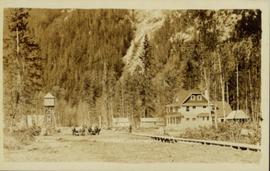
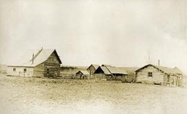
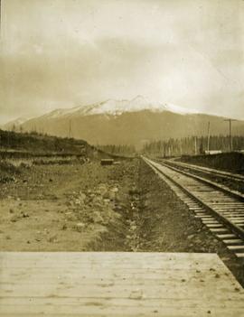
Geographic Features

Elements area

Taxonomy

Code

Scope note(s)

  • Includes both natural and artificial features

  • Physical landscape, built landscape

  • Urban and industrial landscapes

  • Topography

  • Site plans

  • Boundaries, districts, reserves, parks, sanctuaries, towns, etc.

  • NOTE: Mainly but not exclusively pertaining to photographic and cartographic records

  • SEE ALSO: Land, Settlement and Immigration

Source note(s)

  • MemoryBC Subject Groups

Display note(s)

    Hierarchical terms

    Geographic Features

      Equivalent terms

      Geographic Features

        Associated terms

        Geographic Features

          4130 Archival description results for Geographic Features

          4130 results directly related Exclude narrower terms
          Houses on Stilts
          2012.13.1.6.106 · Item · Nov. 1980
          Part of J. Kent Sedgwick fonds

          Image depicts a number of houses built on stilts over a body of water in an uncertain location.

          2011.3.1.06 · Item · [ca. 1905]
          Part of North Coast & Central BC Postcard Collection

          View of peninsula with houses and trees. Dock in mid ground, trees and grasses in foreground. Recto stamped “Port Simpson DE 17" and "Port Essington DE 18". Handwritten annotation on recto of photograph: "W. J. O'Neill Esq. Telegraph Point Via Pt. Essington B.C. Don't you think this pretty [Weggs & Mr. Byron?] was over last night - said he saw you and [Halie?]. Yours - BaBa".

          Houses in Giscome
          2012.13.1.87.072 · Item · [between 1975 and 1995]
          Part of J. Kent Sedgwick fonds

          Image depicts the Giscome B.C. townsite from across the railroad tracks looking southeast. Map coordinates 54°04'19.7"N 122°22'04.7"W

          Houses and Train in Giscome
          2012.13.1.87.073 · Item · [between 1975 and 1995]
          Part of J. Kent Sedgwick fonds

          Image depicts the Giscome B.C. townsite from across the railroad tracks looking southeast. Map coordinates 54°04'19.7"N 122°22'04.7"W

          Houses and Three Goats
          2012.13.1.87.021 · Item · [between 1975 and 1995]
          Part of J. Kent Sedgwick fonds

          Image depicts several houses, and three goats standing on a narrow dirt road. The location is uncertain, likely Sinclair Mills, B.C.

          Houses and a Ballpark
          2012.13.1.93.01 · Item · 1978
          Part of J. Kent Sedgwick fonds

          Image depicts a view of numerous houses and a ballpark at an uncertain location. It is possibly located somewhere in the Peace River Region.

          Houses
          2012.13.1.22.12 · Item · 1970
          Part of J. Kent Sedgwick fonds

          Image depicts numerous houses, and an unknown child standing in a street at Island Cache.

          Houses
          2012.13.1.22.17 · Item · 1970
          Part of J. Kent Sedgwick fonds

          Image depicts a few houses and a dog on a porch at Island Cache.

          House with Ivy
          2012.13.1.87.116 · Item · [between 1970 and 1990]
          Part of J. Kent Sedgwick fonds

          Image depicts a house with ivy growing over it. The location is uncertain.

          2012.13.1.87.050 · Item · [between 1975 and 1995]
          Part of J. Kent Sedgwick fonds

          Image depicts a house being removed from Upper Fraser, B.C. during demolition of town site. A sign on the house reads: "Murray Blackwell House Raising & Moving." Map coordinates 54°06'51.6"N 121°56'26.3"W

          House in Giscome
          2012.13.1.87.159 · Item · [between 1975 and 1995]
          Part of J. Kent Sedgwick fonds

          Image depicts a house in Giscome, B.C. Map coordinates 54°04'17.6"N 122°22'06.1"W

          House 40
          2012.13.1.84.46 · Item · 1994
          Part of J. Kent Sedgwick fonds

          Image depicts a house with a vehicle in a garage and the number 40 on it; location is uncertain.

          House - Elevated Main Floor
          2012.13.1.87.079 · Item · [between 1975 and 1995]
          Part of J. Kent Sedgwick fonds

          Image depicts a house with the main floor and entrance high off the ground. The location is uncertain, likely Giscome, B.C.

          Hospital Beach?
          2012.13.1.84.43 · Item · 1994
          Part of J. Kent Sedgwick fonds

          Image depicts what is possibly Hospital Beach in Kitimat, B.C. The facility in the background is possibly the Alcan smelter.

          Holts Ranch
          2014.10.1.151 · Item · 1911
          Part of Arthur Holland Land Surveying Collection
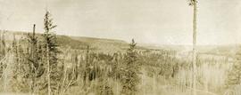
          Photograph depicts a cluster of log buildings with fences and corrals. A field in the foreground, trees and low hills in the distance. On the road from Quesnell to Fraser Lake 1911.

          2006.45 · Fonds · [ca. 1897]

          Contains photographs generally depicting landscapes, water scenes, and views of towns on British Columbia's north coast. Includes images featuring sternwheelers and other boats, canneries, fisheries, and individuals. Locations depicted include Port Essington and Port Simpson (Lax Kw’alaams) in BC, Fort Wrangell in Alaska, and other unknown towns. Includes one photograph of a man named Max Lohbrunner, and many other images depicting unidentified individuals.

          Historic trails
          2012.13.2.13.03 · File · 1982-1986
          Part of J. Kent Sedgwick fonds

          File consists of notes, clippings, and reproductions relating to historic trails in British Columbia. Includes material on The Okanagan Brigade Trail; the exploration trails of Jean Caux (better known as Cataline); and Hudson's Bay Company brigade trails. Includes: "The Okanagan Brigade Trail" pamphlet from the Okanagan Historical Society (1986); "The Okanagan Brigade Trail in the South Okanagan" pamphlet by Bob Harris, Harley Hatfield, and Peter Tassie (1989); and "Historic Routes '82" symposium program (1982).