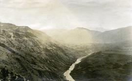
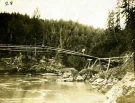
Geographic Features

Elements area

Taxonomy

Code

Scope note(s)

  • Includes both natural and artificial features

  • Physical landscape, built landscape

  • Urban and industrial landscapes

  • Topography

  • Site plans

  • Boundaries, districts, reserves, parks, sanctuaries, towns, etc.

  • NOTE: Mainly but not exclusively pertaining to photographic and cartographic records

  • SEE ALSO: Land, Settlement and Immigration

Source note(s)

  • MemoryBC Subject Groups

Display note(s)

    Hierarchical terms

    Geographic Features

      Equivalent terms

      Geographic Features

        Associated terms

        Geographic Features

          4130 Archival description results for Geographic Features

          4130 results directly related Exclude narrower terms
          2009.7.1.101 · Item · [ca. 1878 - ca. 1915]
          Part of Archdeacon W. H. Collison fonds

          Photograph depicts totem poles (crest poles?) in front of lodge buildings on river shore. Canoes can be seen floating in foreground, hills in background.

          Handwritten annotation on verso reads: "Chapter XII. Number 1. Section of Indian Village on Nass River showing lodges and totems".

          Loading for the Peace River
          2009.5.3.158 · Item · [ca. 1910]
          Part of Taylor-Baxter Family Photograph Collection

          Photograph depicts six men by building on shore. One man sits in small boat that has been loaded onto a wagon. River and opposite shore in background. Handwritten annotation on verso of photograph: "Loading for the Peace River." Photograph believed to have been taken either at Giscome Portage, or the trading post at Summit Lake, BC.

          2006.20.9.24 · Item · [ca. 1897 - 1960]
          Part of Northern BC Archives Historical Photograph Collection

          View of a scow loaded with provisions and several people passing through rapids of the Grand Canyon. Printed annotation on recto reads: “A scow loaded with provisions passing through the Grand Canyon on it’s way to Fort George.” Handwritten annotation in pencil on recto reads: “Nearly Bumped, Nachaco River” Handwritten annotation in pencil on verso reads: “My address will be Fort George BC. Dear Mrs. Cooper, I am up in the wild part of BC now where men horses and everything get drowned every day, sometimes automobiles get drowned also. This is the way we travel up where I am now. I saw a boat upside down in this Canyon it had a bundle of blankets tied on it and one oar was dancing in the whirlpool. This made my hair stand straight up and down.”

          Lillooet Area
          2012.13.1.053 · Subseries · [between 1971 and 1982]
          Part of J. Kent Sedgwick fonds

          File contains slides depicting places in the Lillooet area.

          Likely - Horsefly
          2012.13.1.069 · Subseries · [between 1976 and 1981]
          Part of J. Kent Sedgwick fonds

          File contains slides depicting places in and around the areas of Likely and Horsefly, B.C.

          Likely
          2012.13.1.69.03 · Item · July 1981
          Part of J. Kent Sedgwick fonds

          Image depicts numerous vehicles and individuals outside a hotel in Likely, B.C.

          Likely
          2012.13.1.69.31 · Item · [1981?]
          Part of J. Kent Sedgwick fonds

          Image depicts a bridge, and the town of Likely on the the other side of a river.

          Leo Creek - Office Building?
          2012.13.1.62.22 · Item · June 1978
          Part of J. Kent Sedgwick fonds

          Image depicts a building, possibly an office building, next to a set of rail road tracks in Leo Creek, B.C. An unknown individual is present, and a number of barrels and culverts are visible in the foreground.

          2012.13.1.78.25 · Item · 1982
          Part of J. Kent Sedgwick fonds

          Image depicts numerous boats docked by the Prince Rupert Fishermen's Co-operative Association from the deck of a ferry, possibly as it's leaving Prince Rupert, most likely for Haida Gwaii.

          2012.13.2.14.09 · File · 1987-1989
          Part of J. Kent Sedgwick fonds

          File consists of notes, reproductions, and letters relating to L.C. Gunn Park in Prince George. Includes: "Signage for Gunn Park" letter from Kent Sedgwick to the Mayor and Council (21 Dec. 1989); "L.C. Gunn viewpoint a proposal" documents within a duotang (1987); and "Donation to the City of Prince George" typescript letter from Graham Farstad to the Administration Committee ( 1 June 1988). Includes photographs depicting the opening of L.C. Gunn Park and the sign unveiling (3 Oct. 1988).

          Lava Formation?
          2012.13.1.50.077 · Item · [1978?]
          Part of J. Kent Sedgwick fonds

          Image depicts a formation of rock; presumably solidified lava, as the slide is simply labelled "lava." The location of the image is uncertain.

          2012.13.2.19.20 · File · 1975-1990
          Part of J. Kent Sedgwick fonds

          File consists of notes, clippings, and reproductions relating to lava beds in British Columbia, including Aiyansh, also known as the Tseax Cone, in the Nisga'a Memorial Lava Bed Provincial Park. Includes: "Craters of the Moon Guide" special edition newspaper from the United States National Park Service (1990); and "Craters of the Moon: National Monument, Idaho" pamphlet published from the United States National Park Service (1975). File also contains photographs depicting the Nisga'a Memorial Lava Bed Provincial Park.

          Launching Rebuilt Conveyor
          2009.5.3.56 · Item · 1912
          Part of Taylor-Baxter Family Photograph Collection

          Photograph depicts men standing on different deck levels of conveyor on the Fraser River. Wood planks built into shore in foreground, trees on opposite shore in background. Handwritten annotation on verso of photograph reads: "Launching Conveyor", on recto: "Launching the rebuilt steamer Conveyor at Tete Jaune 1912".

          2002.17.6 · Item · 3 July 1912
          Part of Henderson-Roe collection

          Map is entitled "Latest Map of Fort George District" and published 1912. Includes Peace River Recording Land District, Fort George Land Recording District, and Cariboo Land Recording District. Several sections are marked with red pencil.