Geographic Features

Elements area

Taxonomy

Code

Scope note(s)

  • Includes both natural and artificial features

  • Physical landscape, built landscape

  • Urban and industrial landscapes

  • Topography

  • Site plans

  • Boundaries, districts, reserves, parks, sanctuaries, towns, etc.

  • NOTE: Mainly but not exclusively pertaining to photographic and cartographic records

  • SEE ALSO: Land, Settlement and Immigration

Source note(s)

  • MemoryBC Subject Groups

Display note(s)

    Hierarchical terms

    Geographic Features

      Equivalent terms

      Geographic Features

        Associated terms

        Geographic Features

          4130 Archival description results for Geographic Features

          4130 results directly related Exclude narrower terms
          Likely
          2012.13.1.69.31 · Item · [1981?]
          Part of J. Kent Sedgwick fonds

          Image depicts a bridge, and the town of Likely on the the other side of a river.

          Likely - Horsefly
          2012.13.1.069 · Subseries · [between 1976 and 1981]
          Part of J. Kent Sedgwick fonds

          File contains slides depicting places in and around the areas of Likely and Horsefly, B.C.

          Lillooet Area
          2012.13.1.053 · Subseries · [between 1971 and 1982]
          Part of J. Kent Sedgwick fonds

          File contains slides depicting places in the Lillooet area.

          2006.20.9.24 · Item · [ca. 1897 - 1960]
          Part of Northern BC Archives Historical Photograph Collection

          View of a scow loaded with provisions and several people passing through rapids of the Grand Canyon. Printed annotation on recto reads: “A scow loaded with provisions passing through the Grand Canyon on it’s way to Fort George.” Handwritten annotation in pencil on recto reads: “Nearly Bumped, Nachaco River” Handwritten annotation in pencil on verso reads: “My address will be Fort George BC. Dear Mrs. Cooper, I am up in the wild part of BC now where men horses and everything get drowned every day, sometimes automobiles get drowned also. This is the way we travel up where I am now. I saw a boat upside down in this Canyon it had a bundle of blankets tied on it and one oar was dancing in the whirlpool. This made my hair stand straight up and down.”

          Loading for the Peace River
          2009.5.3.158 · Item · [ca. 1910]
          Part of Taylor-Baxter Family Photograph Collection

          Photograph depicts six men by building on shore. One man sits in small boat that has been loaded onto a wagon. River and opposite shore in background. Handwritten annotation on verso of photograph: "Loading for the Peace River." Photograph believed to have been taken either at Giscome Portage, or the trading post at Summit Lake, BC.

          2009.7.1.101 · Item · [ca. 1878 - ca. 1915]
          Part of Archdeacon W. H. Collison fonds

          Photograph depicts totem poles (crest poles?) in front of lodge buildings on river shore. Canoes can be seen floating in foreground, hills in background.

          Handwritten annotation on verso reads: "Chapter XII. Number 1. Section of Indian Village on Nass River showing lodges and totems".

          2009.6.1.115 · Item · 3 January 1975
          Part of The Honourable Iona Campagnolo fonds
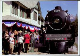
          Photograph depicts a forested mountain, the bottom half of which has been logged and terraced; beneath the mountain is a railroad track and parked vehickes including a schoolbus and two dumptrucks.

          Handwritten annotation on verso reads: “Fairview Sodturning, Prince Rupert, 1/3/75”.

          Logging
          2012.13.1.122.12 · Item · 1977
          Part of J. Kent Sedgwick fonds

          Image depicts a logging area somewhere near Prince George, B.C.

          Logging
          2012.13.1.122.13 · Item · 1977
          Part of J. Kent Sedgwick fonds

          Image depicts a logging area somewhere near Prince George, B.C.

          Logs and Machinery
          2012.13.1.87.056 · Item · [between 1975 and 1995]
          Part of J. Kent Sedgwick fonds

          Image depicts numerous piles of logs, and two unidentified individuals operating an excavator with a "thumb" attachment during the demolition of the Upper Fraser town site. Map coordinates 54°06'51.6"N 121°56'26.3"W

          2012.13.1.87.013 · Item · [between 1975 and 1995]
          Part of J. Kent Sedgwick fonds

          Image depicts a pile of old logs on the bank of the Fraser River with mountains in the background. In the foreground, a set of railway tracks run through an uncertain location, likely Upper Fraser, B.C.

          2011.3.3.64 · Item · 28 June 1928
          Part of North Coast & Central BC Postcard Collection

          Slightly elevated photograph of Prince Rupert buildings. A lone vessel is visible in the background. Printed annotation on recto reads: "Courtesy of Can Nat'l Rys. Prince Rupert. B.C." Handwritten annotation on verso reads: "Dear Elma. We reached Prince Rupert (in the picture) today. Friday we arrive at Skagway and the glaciers. Having a fine trip- good weather and a good crowd. Love from Claire." Postcard is addressed to: "Mrs. Claude Millersh, River Forest, Guerneville, Sonoma Co., California." Postcard is affixed with a two cent American stamp. Postmark on verso reads: "Ketohikan Alaska. Jun 28 3 PM 1928."

          Longworth - Railway Tracks
          2012.13.1.87.031 · Item · [between 1975 and 1995]
          Part of J. Kent Sedgwick fonds

          Image depicts two unidentified individuals standing next to the train station, and two railway tracks running through Longworth, B.C.