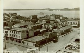
Geographic Features

Elements area

Taxonomy

Code

Scope note(s)

  • Includes both natural and artificial features

  • Physical landscape, built landscape

  • Urban and industrial landscapes

  • Topography

  • Site plans

  • Boundaries, districts, reserves, parks, sanctuaries, towns, etc.

  • NOTE: Mainly but not exclusively pertaining to photographic and cartographic records

  • SEE ALSO: Land, Settlement and Immigration

Source note(s)

  • MemoryBC Subject Groups

Display note(s)

    Hierarchical terms

    Geographic Features

      Equivalent terms

      Geographic Features

        Associated terms

        Geographic Features

          4130 Archival description results for Geographic Features

          4130 results directly related Exclude narrower terms
          Peace River region
          2012.13.2.19.16 · File · 2003-2010
          Part of J. Kent Sedgwick fonds

          File consists of clippings related to the Peace River region. Also includes photographs taken by Kent Sedgwick depicting Mackenzie, BC and the Peace River region (2003).

          Peace River Canyon
          2000.19.2.15 · Item · 29 Aug. 1927-26 Sept. 1927
          Part of Prentiss Gray Collection

          Photograph depicts the Peace River Canyon with the Peace River in the foreground and rocky, tree-lined cliffs flanking the river. In the background a forested mountain base is visible.

          Peace River
          2008.2.1.25 · Item · 2 January 1945
          Part of Northern BC Cartographic Collection

          Colour-coded topographic map depicting surveyed lands alienated, available for purchase or lease, or available for pre-emption. Depicts land districts, land recording districts, parks, communities, bodies of water, transport routes, communication lines, and triangulation stations.

          Peace River
          2012.13.1.091 · Subseries · [between 1974 and 1979]
          Part of J. Kent Sedgwick fonds

          File contains slides depicting places along the Peace River.

          Peace River
          2012.13.1.91.12 · Item · Oct. 1978
          Part of J. Kent Sedgwick fonds

          Image depicts the Peace River, possibly near Clayhurst or Hudson's Hope, B.C.

          Peace River
          2012.13.1.91.13 · Item · Oct. 1978
          Part of J. Kent Sedgwick fonds

          Image depicts the Peace River, possibly near Clayhurst or Hudson's Hope, B.C.

          Peace River?
          2012.13.1.91.06 · Item · Oct. 1978
          Part of J. Kent Sedgwick fonds

          Image depicts what is possibly the Peace River running parallel to a road, possibly Highway 29.

          Peace River
          2012.13.1.93.27 · Item · 1978
          Part of J. Kent Sedgwick fonds

          Image depicts the Peace River and visible layers of sediment deposits in the surrounding cliffs.

          2011.13.53 · Item · 9 August 1911
          Part of Parker photograph collection

          Side perspective photograph of a Portland Canal Short Line engine being either loaded or unloaded by several men at the station in Stewart, BC. Printed annotation on recto reads: "Aug 9 1911 Stewart BC."

          Pat's Pass
          2012.13.1.79.18 · Item · Aug. 1977
          Part of J. Kent Sedgwick fonds

          Image depicts a view of a valley; the slide itself labels the image in two places, "central basin" on the left side of the image, and "Pat's Pass" on the top of the image between the two mountains.

          2012.13.1.87.004 · Item · [between 1975 and 1995]
          Part of J. Kent Sedgwick fonds

          Image depicts several eighteen wheelers at the Pass Lake Road and Upper Fraser Road intersection with numerous houses and buildings in the background in McGregor, B.C. Map coordinates 54°04'38.1"N 121°50'00.1"W

          2009.5.2.52 · Item · [ca. 1910?]
          Part of Taylor-Baxter Family Photograph Collection

          Photograph depicts a man standing in a loaded canoe floating close to shore. Two men stand on rocky shore in left foreground. Tall hills in background, river rapids behind canoe in midground. Handwritten annotation on recto of photograph: "Parle Pas Rapids Peace River."

          Parks and Outdoor Recreation
          2012.13.2.14 · Subseries · 1970-2011
          Part of J. Kent Sedgwick fonds

          Subseries consists of material collected and created by Kent Sedgwick for research regarding parks and outdoor recreation in Prince George. Material on parks includes Fort George Park (renamed to Lheidli T’enneh Memorial Park in 2015); Cottonwood Island Park; Connaught Hill; Moore's Meadow; L.C. Gunn Park; the Nechako Cutbanks; Paddlewheel Park; Monkman Provincial Park; Fraser Canyon Park; and Carp Lake. Also includes information on the creation of plaques and monuments, including the Alexander Mackenzie monument; the “Arrival of Steel” CN railway plaque; heritage interpretative signs for the Grand Trunk Pacific Railway; the Millar addition; and flooding and rivers. The files consists of various pamphlets and correspondence regarding the development of parks and the creation of interpretive materials.

          Parking Lot Frisbee
          2012.13.1.93.18 · Item · 1979
          Part of J. Kent Sedgwick fonds

          Image depicts a group of people throwing a frisbee in a parking lot at an uncertain location, likely in the Peace River Region.

          Parker photograph collection
          2011.13 · Collection · [between 1910 and 1930]

          The photographs depict the geographic areas of Stewart, BC, Boundary Pass, Nelson River, Bitter Creek Glacier, Portland Canal, Red Cliff and Bear Creek; as well as the ships “Camosun” and “S.S. Prince George.” Types of subjects identified in this collection include: community life, surveying, mining and transportation (i.e. dog-sledding, horse and buggy, and the Portland Canal Short Line Railway “P.C.S.L. Rlwy”).

          2012.13.2.14.16 · File · 1988
          Part of J. Kent Sedgwick fonds

          File consists of notes and typescript letters relating to Paddlewheel Park in Prince George. Includes: "Name change from Glenora Park to Paddlewheel Park" typescript letter from Heritage Committee to the Mayor and Council (12 Sept. 1988) and "South Fort George Community Association" typescript letter from Glenn Jaye to Graham Farstad (1 June 1988).

          Paddlewheel Park
          2012.13.1.7.202 · Item · Nov. 2000
          Part of J. Kent Sedgwick fonds

          Image depicts the Fraser River at Paddlewheel park, with a train on the other side of the river, in Prince George B.C.