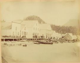
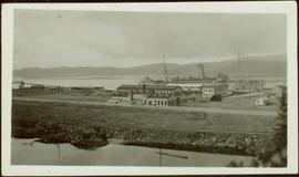
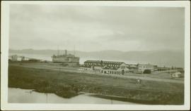
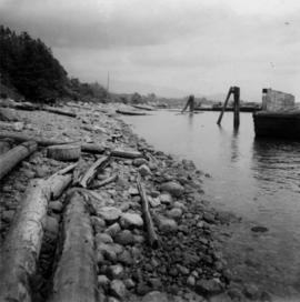
Geographic Features

Elements area

Taxonomy

Code

Scope note(s)

  • Includes both natural and artificial features

  • Physical landscape, built landscape

  • Urban and industrial landscapes

  • Topography

  • Site plans

  • Boundaries, districts, reserves, parks, sanctuaries, towns, etc.

  • NOTE: Mainly but not exclusively pertaining to photographic and cartographic records

  • SEE ALSO: Land, Settlement and Immigration

Source note(s)

  • MemoryBC Subject Groups

Display note(s)

    Hierarchical terms

    Geographic Features

      Equivalent terms

      Geographic Features

        Associated terms

        Geographic Features

          4130 Archival description results for Geographic Features

          4130 results directly related Exclude narrower terms
          Shore Line at Airport
          2012.13.1.124.02 · Item · 1970
          Part of J. Kent Sedgwick fonds

          Image depicts the shore line and surrounding land of a lake or river at an airport, possibly in Prince George, B.C.

          2006.45.11 · Item · [ca. 1897]
          Part of Historical North Coast Photograph Album

          Shops stand along riverside boardwalk. Storefront sign for R. Cunningham & Sons visible. Many people stand and sit on boardwalk, and canoes and small boats float in water in foreground.

          Handwritten photo captions beside image read: "R. Cunningham & Sons - Probably Port Essington", "NW coast canoe".

          Shacks and a Mountain
          2012.13.1.87.028 · Item · [between 1975 and 1995]
          Part of J. Kent Sedgwick fonds

          Image depicts two old shacks and a mountain in the background. Possibly located in or near Longworth, B.C.

          Seton Portage Area
          2012.13.1.82.12 · Item · July 1980
          Part of J. Kent Sedgwick fonds

          Image depicts a view of the area surrounding Seton Portage, B.C. Seton and Anderson Lake are both visible, with what is possibly either Seton Portage or Nosebag mountain also present.

          Seton Lake, Lillooet
          2020.08.29 · Item · [1914 or 1915?]
          Part of Pacific Great Eastern Railway Region Photograph Collection

          Photograph depicts the steam-operated sawmill at Seton Lake and a fish weir at the mouth of the creek. The railway grade alongside the lake, constructed circa 1914-1915, is visible in the background. The Seton Lake fish hatchery, which built and used the fish weir, ceased operations in 1915, dating this photograph sometime around 1914 or 1915.

          Seton Lake
          2020.08.30 · Item · [between 1908 and 1914]
          Part of Pacific Great Eastern Railway Region Photograph Collection

          Photograph depicts a view of the east end of Seton Lake. The Seton Lake sawmill and Seton Lake fish hatchery are visible in the foreground. The PGE railway grade alongside the lake has not yet been constructed, dating this photograph at or before 1914.

          Separated photographs
          2012.13.1.135 · Subseries · 1980-2011
          Part of J. Kent Sedgwick fonds

          File consists of photographs separated from other boxes and subseries depicting downtown Prince George, historic Prince George, the North Thompson region, Fort St. James historic site, Brooks, Alberta, Sinclair Mills, and Soda Creek.

          Sediment Layers
          2012.13.1.91.24 · Item · Oct. 1978
          Part of J. Kent Sedgwick fonds

          Image depicts an unidentified individual standing in front of a rock face with visible sediment layers. Located somewhere in the Peace River Region, possibly near Hudson's Hope.

          Sediment Layers
          2012.13.1.91.27 · Item · Oct. 1978
          Part of J. Kent Sedgwick fonds

          Image depicts a wall of rock with visible sediment layers at an uncertain location in the Peace River Region, possibly near Hudson's Hope.

          2006.20.11.2 · Item · [ca. 1900]
          Part of Northern BC Archives Historical Photograph Collection

          Photograph depicts a street scene along Second St. in Fort George. Wagons line the dirt road which is flanked by wooden buildings. A group of unidentified men stand on the boardwalk outside of Rigg's Restaurant. Handwritten annotation along bottom of photograph: "Second St. Ft. George".

          2011.3.3.41 · Item · 5 August 1925
          Part of North Coast & Central BC Postcard Collection

          Side perspective street view of the Canadian Bank of Commerce on a deserted dirt road. Printed annotation on recto reads: "2nd Ave Prince Rupert BC." Illegible faded photographer's mark on lower right corner. Handwritten annotation on verso reads: "The houses and pavements are made of wood. Love Daddy. xx." Postcard is addressed to: "Miss Greta Poole 'Airoudale'[??] Collingwood Road Paigulou Devon England." Postmark on verso reads: "Prince Rupert BC 10:30 AM Aug 5 1925."

          Seal Cove, Prince Rupert, BC
          2011.3.3.8 · Item · 1914
          Part of North Coast & Central BC Postcard Collection

          View from water of large industrial building (cannery?). Handwritten annotation in pencil on verso reads: “Seal Cove BC P. Rupert BC.” Handwritten message in ink on verso is addressed to “Miss Belding 33 Marlbro Avenue Hull Josks Eng.” 2 cancelled Canadian postage stamps read: “Vancouver B.C. Jul 4, 8 PM 1914”

          Scow's Last Lap
          2009.5.3.10 · Item · [ca. 1913]
          Part of Taylor-Baxter Family Photograph Collection

          Photograph depicts a crew of 13 men on a scow believed to be maneuvering through the Upper Fraser River at Scow's Last Lap (Scow Rapids), downriver from the Grand Canyon of the Fraser. Trees on opposite shore in background, rocky shore in foreground. Handwritten annotation on recto of photograph reads: "the last lap".