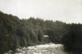
Colour-coded topographic map depicting lands surveyed as alienated, available for purchase or lease under Land Act, or reserved. Depicts land district boundaries, land recording divisions, provincial forest boundaries, HBC posts, triangulation stations, telephone lines, communities, bodies of water, and transport routes.
Elements area
Taxonomy
Code
Scope note(s)
Includes both natural and artificial features
Physical landscape, built landscape
Urban and industrial landscapes
Topography
Site plans
Boundaries, districts, reserves, parks, sanctuaries, towns, etc.
NOTE: Mainly but not exclusively pertaining to photographic and cartographic records
SEE ALSO: Land, Settlement and Immigration
Source note(s)
MemoryBC Subject Groups