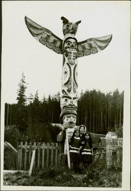
Geographic Features

Elements area

Taxonomy

Scope note(s)

  • Includes both natural and artificial features

  • Physical landscape, built landscape

  • Urban and industrial landscapes

  • Topography

  • Site plans

  • Boundaries, districts, reserves, parks, sanctuaries, towns, etc.

  • NOTE: Mainly but not exclusively pertaining to photographic

  • Read more

Source note(s)

  • MemoryBC Subject Groups

4135 Archival description results for Geographic Features

4135 results directly related Exclude narrower terms
Three People, Three Dogs
2012.13.1.84.04 · Item · 1994
Part of J. Kent Sedgwick fonds

Image depicts three individuals and three dogs standing by a stream at an uncertain location, possibly somewhere in Bear Glacier Provincial Park. The woman in purple is possibly Sue Sedgwick.

Three People on a Beach
2012.13.1.67.02 · Item · 1979
Part of J. Kent Sedgwick fonds

Image depicts two individuals seated at a picnic table while a third stands closer to the water on a beach somewhere in Kitimat, B.C. What appears to be a harbour can be seen on the water.

Three Hikers
2012.13.1.65.15 · Item · May 1975
Part of J. Kent Sedgwick fonds

Image depicts a view of the scenery, with three hikers in the bottom left corner of the image.

Three diversion tunnels
2000.13.1.66 · Item · [between 1962 and 1967].
Part of Ray Williston fonds

Item is a photograph of the three tunnels built to divert the Peace River around the Bennett Dam construction site.

Three Children and Two Goats
2012.13.1.87.022 · Item · [between 1975 and 1995]
Part of J. Kent Sedgwick fonds

Image depicts three unidentified children standing in the doorway of a house, with two goats ascending the porch steps. The location is uncertain, likely Sinclair Mills, B.C.

2014.10.1.008 · Item · 1907
Part of Arthur Holland Land Surveying Collection

Photograph depicts six horses harnessed to a center pole. Three men attend the horses, two men with pitchforks stand atop a wagon loaded with cut grain stocks in the background. Note: Fort Fraser, BC was at one time also referred to as "Fraser's Lake" -Read more

2011.12.01 · Item · ca. 1950
Part of Giscome, BC Historical Photograph collection

Photo depicts a street perspective of Third Ave., in Prince George, BC, ca. 1950. Handwritten annotation in pen on verso of postcard reads: “You will undoubtedly notice that there are no tall buildings. I don’t think that there is one building in PrinceRead more

The Tutshi
2012.13.1.98.06 · Item · 1999
Part of J. Kent Sedgwick fonds

Image depicts half of a ship, which is named the Tutshi, in Carcross, Y.T.

2012.13.2.19.29 · File · 1972
Part of J. Kent Sedgwick fonds

File consists of a pamphlet titled "The Quesnel-Lillooet Bulletin Area" prepared by the Department of Lands, Forests, and Water Resources from the Province of British Columbia. The pamphlet is a revised 2nd edition published in 1973, the original was published in 1968.

2011.3.4.15 · Item · 24 December 1915
Part of North Coast & Central BC Postcard Collection

Stern wheeler “Port Simpson” tied to riverbank. Printed annotation on recto reads: “On the Skeena river, Hazelton, B.C.” Handwritten message on verso is addressed to “Mrs. Flossie Strong 6 Nah St. Watermill ME, U.S.A” 1 cent Canadian postage stamp hasRead more

2009.7.1.263 · Item · 21 January 1914
Part of Archdeacon W. H. Collison fonds

Photograph of a large explosion next to a huge pile of debris. Buildings are visible on either side and railroad track can be seen in the foreground. Annotation on recto reads: "The Last Big Blast, Prince Rupert BC 21 Jan 1914 McRae Bros. Photo"

The Duke of Connaught
2012.13.2.02.37 · File · 2001-2007
Part of J. Kent Sedgwick fonds

File consists of notes and reproductions relating to Prince Arthur the Duke of Connaught, the third son of Queen Victoria who took the place of Governor General in Canada in 1911. Connaught Hill in Prince George was named in rememberance after PrinceRead more

The Bullion Pit
2012.13.1.69.25 · Item · [1981?]
Part of J. Kent Sedgwick fonds

Image depicts the Bullion Pit in Likely, B.C. It is a man-made canyon from the days of the gold-rush, formed by the use of hydraulic monitors. The gold-mine operated from 1892 to 1942.

The Bourchier Album
2009.5.3 · File · [ca. 1895 - 1950]
Part of Taylor-Baxter Family Photograph Collection

This photograph album consists of photographs of remote police barracks at Mile 47 and Mile 29; early settlements and/or mercantile stores at Tete Jaune Cache, McBride, Sand Creek, Fort George and South Fort George; Grand Trunk Pacific Railway forestryRead more

Bourchier, Alan K.
Tete Jaune
2012.13.2.17.33 · File · 1980-1994
Part of J. Kent Sedgwick fonds

File consists of notes, clippings, and reproductions relating to Tete Jaune.

Terzaghi Dam
2012.13.1.59.22 · Item · July 1980
Part of J. Kent Sedgwick fonds

Image depicts the Terzaghi Dam viewed from the downstream side near Bralorne B.C.