Environment

Elements area

Taxonomy

Code

Scope note(s)

  • Includes: environmental issues; nature, wilderness and scenery; climate and weather; environmentalists; environmental organizations and businesses; parks and natural areas; wildlife management; habitat and species protection/recovery; conservation activities.

Source note(s)

  • MemoryBC Subject Groups

Display note(s)

    Hierarchical terms

    Environment

      Equivalent terms

      Environment

        Associated terms

        Environment

          61 Archival description results for Environment

          61 results directly related Exclude narrower terms
          2006.20.10.12 · Item · [ca. 1930 - 1940]
          Part of NBCA Photograph Collection

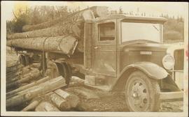
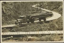
          Fully loaded logging truck driving along a wood plank logging road. Another road under construction is also visible through forest in background.

          Handwritten annotation in pencil on verso reads: “Logging - Giscome B.C. Plank truck road - also road under construction showing sills & cribbing."

          2006.20.10.5 · Item · [ca. 1930 - 1940]
          Part of NBCA Photograph Collection

          An “Indiana” flatbed logging truck releases logs from its load onto a makeshift log slide at the edge of a road.

          Handwritten annotation in pencil on verso: "unloading logs".

          Sawmill at Giscome, BC
          2006.20.10.9 · Item · [ca. 1930 - 1940]
          Part of NBCA Photograph Collection

          Handwritten annotation in pencil on verso: "Daily Capacity 100,000 f.b.m. sawmill in foreground planer mill and lumber yard in background.”

          2011.12.05 · Item · [ca. September 1950- June 1951]
          Part of Giscome, BC Historical Photograph collection

          Photograph of various plant life with Eagle Lake visible in the background. Handwritten annotation in pen on verso reads: “Eagle Lake from the top of the bluff. Eagle Lake is about 7 miles long & about 1 mile wide. It is a fair sized lake.”

          Open Field in Giscome
          2012.13.1.87.069 · Item · [between 1975 and 1995]
          Part of J. Kent Sedgwick fonds

          Image depicts a field in Giscome, B.C. On the right side of the image, in the background, is a grey strip that appears to be a mine, possibly the quarry at Eaglet Lake in Giscome, B.C. Map coordinates 54°03'52.9"N 122°22'10.0"W

          Open Field in Giscome
          2012.13.1.87.068 · Item · [between 1975 and 1995]
          Part of J. Kent Sedgwick fonds

          Image depicts a field in Giscome, B.C. On the right side of the image, in the background, is a grey strip that appears to be a mine, possibly the quarry at Eaglet Lake in Giscome, B.C. Map coordinates 54°03'52.9"N 122°22'10.0"W

          Open Field in Giscome
          2012.13.1.87.163 · Item · [between 1975 and 1995]
          Part of J. Kent Sedgwick fonds

          Image depicts an open field and Giscome, B.C. in the background. Map coordinates 54°03'52.9"N 122°22'10.0"W

          Mill Site at Giscome, BC
          2006.20.10.8 · Item · [ca. 1930 - 1940]
          Part of NBCA Photograph Collection

          Overview of the Giscome sawmill behind road. Lumber yard is visible in foreground while mill stands in background.

          Handwritten annotation in pencil on verso: "Giscome Mill / lumber yard in foreground".

          Mill Burner at Giscome, BC
          2006.20.10.7 · Item · [ca. 1930 - 1940]
          Part of NBCA Photograph Collection

          Man driving a two horse cart in front of beehive burner, cart is full of bark presumably sawed off the logs.

          Handwritten annotation in pencil on verso: "Mill Burner".

          Logging Truck at Giscome, BC
          2006.20.10.11 · Item · [ca. 1930 - 1940]
          Part of NBCA Photograph Collection

          Fully loaded logging truck driving along a switchback, wood plank logging road.

          Handwritten annotation in pencil on verso reads: “Truck Logging / Giscome BC.”

          Industries
          2006.20.10 · File · [ca. 1900 - 1940]
          Part of NBCA Photograph Collection

          Photographs within this file document resource industries within Northern BC such as mining, fishing, forestry etc. They also represent resource industry cooperatives, processing, packing and shipping industries, construction and ship building, as well as salvage companies and operations.

          House in Giscome
          2012.13.1.87.159 · Item · [between 1975 and 1995]
          Part of J. Kent Sedgwick fonds

          Image depicts a house in Giscome, B.C. Map coordinates 54°04'17.6"N 122°22'06.1"W

          Giscome Sawmill
          2012.13.1.87.176 · Item · [between 1975 and 1995]
          Part of J. Kent Sedgwick fonds

          Image depicts the Giscome, B.C. mill site looking west. Map coordinates 54°04'18.5"N 122°21'57.7"W

          Giscome Quarry
          2012.13.1.87.074 · Item · [between 1975 and 1995]
          Part of J. Kent Sedgwick fonds

          Image depicts what is possibly the quarry located at Eaglet Lake in Giscome, B.C.

          Giscome Landscape
          2012.13.1.87.071 · Item · [between 1975 and 1995]
          Part of J. Kent Sedgwick fonds

          Image depicts an open area with Eaglet Lake in the background. It depicts the previous site of the mill at Giscome, B.C. Map coordinates 54°04'19.7"N 122°22'04.7"W

          2012.13.1.89.084 · Item · [1980?]
          Part of J. Kent Sedgwick fonds

          Image depicts Giscome with the school on the left, the remnants of the town site in the middle and the church on the right. Map coordinates 54°03'58.2"N 122°22'04.8"W

          Giscome Dairy Farm
          2012.13.1.87.083 · Item · [between 1975 and 1995]
          Part of J. Kent Sedgwick fonds

          Image depicts a large, old and collapsing barn, as well as a nearby house of the dairy farm in Giscome, B.C. Map coordinates 54°03'53.3"N 122°21'22.6"W

          Giscome Dairy Farm
          2012.13.1.87.141 · Item · [between 1975 and 1995]
          Part of J. Kent Sedgwick fonds

          Image depicts the dairy farm in Giscome, B.C. Map coordinates 54°03'53.3"N 122°21'22.6"W

          Giscome Dairy Farm
          2012.13.1.87.152 · Item · [between 1975 and 1995]
          Part of J. Kent Sedgwick fonds

          Image depicts the dairy farm in Giscome, B.C. Map coordinates 54°03'53.3"N 122°21'22.6"W

          Giscome Community Hall
          2012.13.1.87.160 · Item · [between 1975 and 1995]
          Part of J. Kent Sedgwick fonds

          Image depicts the Giscome Community Hall in Giscome, B.C. Map coordinates 54°04'18.5"N 122°21'57.7"W

          Giscome CN Station
          2012.13.1.87.161 · Item · [between 1975 and 1995]
          Part of J. Kent Sedgwick fonds

          Image depicts the old CN station in Giscome, B.C. Map coordinates 54°04'20.7"N 122°22'01.1"W

          Giscome Bunkhouse
          2012.13.1.87.158 · Item · [between 1975 and 1995]
          Part of J. Kent Sedgwick fonds

          Image depicts the Giscome bunkhouse in Giscome, B.C. Map coordinates 54°04'17.6"N 122°22'06.1"W

          2012.13.1.87.087 · Item · [between 1975 and 1995]
          Part of J. Kent Sedgwick fonds

          Image depicts the Giscome mill site in Giscome, B.C. The railroad tracks are in the foreground. Map coordinates 54°04'17.6"N 122°22'06.1"W

          Giscome - Power Poles
          2012.13.1.87.098 · Item · [between 1975 and 1995]
          Part of J. Kent Sedgwick fonds

          Image depicts the remains of a street of houses in Giscome, B.C. The quarry is slightly visible in the background. Map coordinates 54°04'20.9"N 122°21'53.1"W

          Giscome - Eaglet Lake
          2012.13.1.87.090 · Item · [between 1980 and 2000]
          Part of J. Kent Sedgwick fonds

          Image depicts mill site and dock in Giscome, B.C. with Eaglet Lake in the background covered in ice. There is a large crowd of people gathered near the dock. Map coordinates 54°04'34.9"N 122°21'50.0"W

          Giscome
          2012.13.1.87.175 · Item · [between 1975 and 1995]
          Part of J. Kent Sedgwick fonds

          Image depicts the Giscome, B.C. town site with the Giscome railway station and the Giscome store in the center surrounded by vehicles. Map coordinates 54°04'18.5"N 122°21'57.7"W