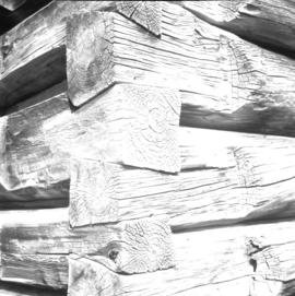
Buildings and Structures

Elements area

Taxonomy

Code

Scope note(s)

  • Includes: buildings; monuments and statues; bridges and trestles; building management; construction.

  • DO NOT USE for records pertaining to activities carried out in or on a building or structure, unless the building and the activity are directly related (e.g. hotels).

Source note(s)

  • MemoryBC Subject Groups

Display note(s)

    Hierarchical terms

    Buildings and Structures

      Equivalent terms

      Buildings and Structures

        Associated terms

        Buildings and Structures

          4442 Archival description results for Buildings and Structures

          4442 results directly related Exclude narrower terms
          Glenwalker Ranch
          2013.6.36.1.078.01 · Item · [13 May 1979]
          Part of David Davies Railway Collection

          Photograph depicts Glenwalker Ranch. Visible are details of the log construction of a barn that was built between 1890 and 1910.

          Giscome Street Scene
          2012.13.1.87.173 · Item · [between 1975 and 1995]
          Part of J. Kent Sedgwick fonds

          Image depicts a street in Giscome B.C. The Giscome Store is located on the left side of the image with the church in the background. Map coordinates 54°04'18.5"N 122°21'57.7"W

          Giscome Station
          2012.13.1.6.034 · Item · May 1975
          Part of J. Kent Sedgwick fonds

          Image depicts the old Giscome Train Station in Giscome, B.C. It was demolished between 1976 and 1977.

          2011.12.09 · Item · [ca. September 1950- June 1951]
          Part of Giscome, BC Historical Photograph collection

          Street view featuring a dirt road leading directly to Giscome School, a three room institution. On the right the steeple of the Catholic church is visible, beside which was Neff’s (sp?) corner store. Handwritten annotation in pen on verso reads: “Looking up our street. The school is at the end.”

          Giscome School - Before
          2012.13.1.87.084 · Item · [between 1980 and 2000?]
          Part of J. Kent Sedgwick fonds

          Image depicts the Giscome mill site in Giscome, B.C. The bunkhouse is in the background on the left and the school is in the foreground on the right. Map coordinates 54°04'04.8"N 122°22'04.7"W

          Giscome School - After
          2012.13.1.87.085 · Item · [between 1975 and 1995]
          Part of J. Kent Sedgwick fonds

          Image depicts the Giscome mill site in Giscome, B.C. The bunkhouse is no longer there and the school is in the foreground on the right. Map coordinates 54°04'04.8"N 122°22'04.7"W

          Giscome Sawmill
          2012.13.1.87.167 · Item · [between 1975 and 1995]
          Part of J. Kent Sedgwick fonds

          Image depicts the mill site at Giscome, B.C. Map coordinates 54°04'19.7"N 122°22'04.7"W

          Giscome Sawmill
          2012.13.1.87.171 · Item · [between 1975 and 1995]
          Part of J. Kent Sedgwick fonds

          Image depicts the mill site at Giscome, B.C. A sign in the foreground reads "Maynard's Industrial Auctioneers." Map coordinates 54°04'19.7"N 122°22'04.7"W

          Giscome Sawmill
          2012.13.1.87.168 · Item · [between 1975 and 1995]
          Part of J. Kent Sedgwick fonds

          Image depicts the mill site at Giscome, B.C. Map coordinates 54°04'19.7"N 122°22'04.7"W

          Giscome Sawmill
          2012.13.1.87.170 · Item · [between 1975 and 1995]
          Part of J. Kent Sedgwick fonds

          Image depicts the mill site at Giscome, B.C. Map coordinates 54°04'19.7"N 122°22'04.7"W

          Giscome Sawmill
          2012.13.1.87.176 · Item · [between 1975 and 1995]
          Part of J. Kent Sedgwick fonds

          Image depicts the Giscome, B.C. mill site looking west. Map coordinates 54°04'18.5"N 122°21'57.7"W

          Giscome Sawmill
          2012.13.1.87.169 · Item · [between 1975 and 1995]
          Part of J. Kent Sedgwick fonds

          Image depicts the mill site at Giscome and its beehive burner. Map coordinates 54°04'19.7"N 122°22'04.7"W

          Giscome Quarry
          2012.13.1.87.074 · Item · [between 1975 and 1995]
          Part of J. Kent Sedgwick fonds

          Image depicts what is possibly the quarry located at Eaglet Lake in Giscome, B.C.

          2009.5.3.150 · Item · [ca. 1910]
          Part of Taylor-Baxter Family Photograph Collection

          Photograph depicts people on river shore, and boat and buildings in midground. River bank in foreground, forest in background. Handwritten annotation on verso of photograph: "Giscombe Portage Fraser River", on recto: "Huble & Seaback on Fraser River."

          Giscome Parking Lot
          2012.13.1.87.174 · Item · [between 1975 and 1995]
          Part of J. Kent Sedgwick fonds

          Image depicts a parking lot full of vehicles with the Giscome store in the background. Map coordinates 54°04'18.5"N 122°21'57.7"W

          Giscome Landscape
          2012.13.1.87.071 · Item · [between 1975 and 1995]
          Part of J. Kent Sedgwick fonds

          Image depicts an open area with Eaglet Lake in the background. It depicts the previous site of the mill at Giscome, B.C. Map coordinates 54°04'19.7"N 122°22'04.7"W

          Giscome Houses
          2012.13.1.87.164 · Item · [between 1975 and 1995]
          Part of J. Kent Sedgwick fonds

          Image depicts a row of houses at an uncertain location, possibly in Giscome, B.C.

          2012.13.1.89.084 · Item · [1980?]
          Part of J. Kent Sedgwick fonds

          Image depicts Giscome with the school on the left, the remnants of the town site in the middle and the church on the right. Map coordinates 54°03'58.2"N 122°22'04.8"W

          Giscome Dock and Wood Scraps
          2012.13.1.87.166 · Item · [between 1975 and 1995]
          Part of J. Kent Sedgwick fonds

          Image depicts a dock at an inlet of Eaglet Lake in Giscome, B.C. There are numerous logs and other pieces of wood scattered in the foreground. Map coordinates 54°04'34.9"N 122°21'50.0"W

          Giscome Dairy Farm
          2012.13.1.87.083 · Item · [between 1975 and 1995]
          Part of J. Kent Sedgwick fonds

          Image depicts a large, old and collapsing barn, as well as a nearby house of the dairy farm in Giscome, B.C. Map coordinates 54°03'53.3"N 122°21'22.6"W

          Giscome Dairy Farm
          2012.13.1.87.141 · Item · [between 1975 and 1995]
          Part of J. Kent Sedgwick fonds

          Image depicts the dairy farm in Giscome, B.C. Map coordinates 54°03'53.3"N 122°21'22.6"W

          Giscome Community Hall
          2012.13.1.87.160 · Item · [between 1975 and 1995]
          Part of J. Kent Sedgwick fonds

          Image depicts the Giscome Community Hall in Giscome, B.C. Map coordinates 54°04'18.5"N 122°21'57.7"W

          Giscome CN Station
          2012.13.1.87.161 · Item · [between 1975 and 1995]
          Part of J. Kent Sedgwick fonds

          Image depicts the old CN station in Giscome, B.C. Map coordinates 54°04'20.7"N 122°22'01.1"W

          Giscome Bunkhouse
          2012.13.1.87.158 · Item · [between 1975 and 1995]
          Part of J. Kent Sedgwick fonds

          Image depicts the Giscome bunkhouse in Giscome, B.C. Map coordinates 54°04'17.6"N 122°22'06.1"W

          2012.13.1.87.086 · Item · [between 1980 and 2000]
          Part of J. Kent Sedgwick fonds

          Image depicts the Giscome mill site in Giscome, B.C. The bunkhouse is the large building with many windows. A train and railroad tracks are in the foreground. Map coordinates 54°04'17.6"N 122°22'06.1"W

          Giscome - Power Poles
          2012.13.1.87.098 · Item · [between 1975 and 1995]
          Part of J. Kent Sedgwick fonds

          Image depicts the remains of a street of houses in Giscome, B.C. The quarry is slightly visible in the background. Map coordinates 54°04'20.9"N 122°21'53.1"W

          Giscome - Eaglet Lake
          2012.13.1.87.090 · Item · [between 1980 and 2000]
          Part of J. Kent Sedgwick fonds

          Image depicts mill site and dock in Giscome, B.C. with Eaglet Lake in the background covered in ice. There is a large crowd of people gathered near the dock. Map coordinates 54°04'34.9"N 122°21'50.0"W

          Giscome - Church
          2012.13.1.87.099 · Item · [between 1975 and 1995]
          Part of J. Kent Sedgwick fonds

          Image depicts a church in Giscome, B.C. Map coordinates 54°04'16.2"N 122°21'54.3"W