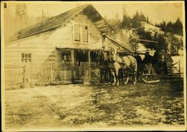
Buildings and Structures

Elements area

Taxonomy

Code

Scope note(s)

  • Includes: buildings; monuments and statues; bridges and trestles; building management; construction.

  • DO NOT USE for records pertaining to activities carried out in or on a building or structure, unless the building and the activity are directly related (e.g. hotels).

Source note(s)

  • MemoryBC Subject Groups

Display note(s)

    Hierarchical terms

    Buildings and Structures

      Equivalent terms

      Buildings and Structures

        Associated terms

        Buildings and Structures

          4442 Archival description results for Buildings and Structures

          4442 results directly related Exclude narrower terms
          2009.5.3.23 · Item · [ca. 1914]
          Part of Taylor-Baxter Family Photograph Collection

          Photograph depicts two men seated in horse-drawn sled. Horses stand in front of short picket fence in foreground, large log building and shed in midground. Trees on hill visible in background. It is speculated that the man seated behind the white horse may be Mr. A. K. Bourchier. Handwritten annotation on recto of photograph: "Alexandria road house".

          Horses
          2012.13.1.31.04 · Item · 1985
          Part of J. Kent Sedgwick fonds

          Image depicts several horses near a camper somewhere in Quesnelle Forks, B.C.

          Honey Sales
          2012.13.1.91.57 · Item · 1979
          Part of J. Kent Sedgwick fonds

          Image depicts several unidentified individuals standing in front of a store selling honey.

          2007.17.1.9 · Item · [ca. 1935]
          Part of James Joseph Claxton Photograph Collection

          Photograph depicts a dam and spillway obstructing a creek. Photo is adhered to paper backing, upon which handwritten annotation on recto reads: “This is the dam and spillway about nine miles up Hixon Creek belonging to the Hixon Creek Cariboo Gold Co., whose main camp on Hixon Creek was at the falls. A fellow Sterling or Bill Tordiffe & I took a contract to cut the logs for this dam in January 1934. The first few winters Quart [sic] Quesnel Quartz had to shut down for snow”

          2007.17.1.3 · Item · [ca. 1934]
          Part of James Joseph Claxton Photograph Collection

          Photograph depicts a dam and wooden spillway along a creek. Annotation on verso reads: "This is the dam and spillway about 9 miles up Hixon Creek belonging to the Hixon Creek Cariboo Gold Co. Original handwritten annotations on verso of photograph are signed by Tom Marsh and covered by mounting the photo on paper. Photograph is taped to paper. Typed annotation on recto of paper reads: “This is the dam and spillway about nine miles up Hixon Creek belonging to the Hixon Creek Cariboo Gold Co., whose main camp on Hixon Creek was at the falls. A fellow Sterling or (Bill) Tordiffe & I took a contract to cut the logs for this dam in January 1934. The first few winters Quesnel Quartz had to shut down for snow."

          2006.45 · Fonds · [ca. 1897]

          Contains photographs generally depicting landscapes, water scenes, and views of towns on British Columbia's north coast. Includes images featuring sternwheelers and other boats, canneries, fisheries, and individuals. Locations depicted include Port Essington and Port Simpson (Lax Kw’alaams) in BC, Fort Wrangell in Alaska, and other unknown towns. Includes one photograph of a man named Max Lohbrunner, and many other images depicting unidentified individuals.

          Highway 97
          2012.13.1.3.021 · Item · Oct. 1975
          Part of J. Kent Sedgwick fonds

          Image depicts Highway 97 at 15th Ave. looking north. Map coordinates 53°54'36.0"N 122°46'55.5"W

          Highway 97
          2012.13.1.3.022 · Item · Oct. 1975
          Part of J. Kent Sedgwick fonds

          Image depicts Highway 97 at 15th Ave. looking north. Map coordinates 53°54'42.1"N 122°46'53.1"W

          Highway 97
          2012.13.1.3.164 · Item · May 2001
          Part of J. Kent Sedgwick fonds

          Image depicts a section of Highway 97 looking south. Map coordinates 53°55'10.3"N 122°46'54.9"W

          H.F. Glassey with Wolf Pelts
          2009.5.2.67 · Item · [ca. 1935]
          Part of Taylor-Baxter Family Photograph Collection

          Photograph depicts H.F. Glassey wearing a suit and tie, holding up a wolf pelt in both hands. House stands behind Glassey, pelts hanging from eaves in front of porch. These pelts came from the Teslin Lake area (this region spans Northern British Columbia and the Yukon Territory). Anglican Church partially visible in left background. Typed annotation on recto of photograph: "Come up and do some hunting." Typed caption below this photograph: "Atlin." See also items 2009.5.2.68 & 2009.5.2.69.

          2009.5.2.83 · Item · [ca. 1935]
          Part of Taylor-Baxter Family Photograph Collection

          Photograph depicts Bert Glassey standing on wood sidewalk in front of building believed to be a small hotel. A dog stands in doorway, and a woman can be seen walking beside building. Trees and hills in background. Sign partially visible to left of Glassey reads "ROOMS".

          2009.5.2.86 · Item · [ca. 1935]
          Part of Taylor-Baxter Family Photograph Collection

          Photograph depicts Bert Glassey standing with two men on deck of building with the sign "POST OFFICE". Snow bank in foreground, two other buildings visible in right background. Typed annotation on recto of photograph: "Nesutlane Trading Post, at Teslin Lake, Yukon T. Self, Moor R.C.M.P and Stewart B.C. Police. Moore is a Brother of Verge."