Slide depicts a view of what is possibly the Upper Fraser River.
Aleza Lake, BC
250 Archival description results for Aleza Lake, BC
The Upper Fraser Historical Geography Project was conducted by UNBC faculty and a team of researchers between 1999 and 2002. The lead researchers were Aileen Espritiu, Gail Fondahl, Greg Halseth, Debra Straussfogel, and Tracy Summerville. The project resulted in the creation of 93 oral history records and their transcripts. Participants included regional forest industry executives, politicians (including former MLA Ray Williston, local mayors and Fraser Fort George Regional District representatives), forest industry workers, and former and contemporary Upper Fraser community residents. The oral histories document the rise, consolidation and demise of the forestry-based settlements along the Upper Fraser River between 1915 and 2000.
File consists of a booklet prepared for the May 9, 2002 UNBC/UBC Aleza Lake Research Forest Field Tour.
File contains a photocopied version of "Tree Farm Licence No. 29 - Eagle Lake Sawmills Ltd. Cutting Permit Application No. 7". Although this item is not related to the Aleza Lake Research Forest, it is relevant to forest history in the Prince George area and therefore retained by the Society.
Slide depicts cleared ground and felled trees in a forested area, likely at the Aleza Lake Experiment Station.
File contains an original copy of a BC Forest Service publication entitled "The Development of the Spruce-Balsam Type in the Aleza Lake Experimental Forest" by A.R. Fraser and J.L. Alexander.
File contains a photocopy of the BC Forest Service publication entitled "The Aleza Lake Research Forest: 'A Rich Past and a Bright Future' Provincial Colleges Tour" from June 1991.
File consists of 1 audiocassette of public presentation hosted by Bob Harkins discussing the history of sawmilling in Prince George Region. Introduces several people involved in sawmilling industry and also discusses history of the Northern Interior Lumbermen's Association. Also shows a historical film about sawmilling and provides commentary.
Harkins, BobFile consists of 19 photographs depicting Harry Coates, experiments, landscapes, and air photos, including:
- Photo pf Harry Coates ca. 1958 at Aleza lake Experiment Station
- Photo of Lloyd Brothers at Cluculz Lake, Gordon Talbot
- 3 photos: including a photo of pine trees, a photo of Harry Coates with a damaged tree, and a photo of a damaged pine
- 1 photo of a young man in safety gear sitting in the back of a parked pickup struck, holding circular saw and smiling at the camera
- 3 photos of cleared forest in the winter
- 2 photos from EP 442 Wansa Lake, P. 60, 61 and 70
- 3 photos of Fire Study June 1984
- 1 photo of EP 657.03 Squirral Damage, June 1984
- 1 photo EP 868.07 McBride May 1984
- 3 photos of Bobtail Demo 660 in 1992, EP 657.03.
File consists of slides depicting the Aleza Lake Research Forest and area taken by Michael Jull.
File consists of slides depicting the Aleza Lake Research Forest and area taken by John Revel.
Reproduced map on mylar depicts locations of elevations and benchmarks at the Aleza Lake forest.
File consists of 35 photographs of trees, cleared forest land, experimental plots sites, plantations, equipment, and one photograph of Harry Coates.
- 8 photos in folder "FES [Forest Experiment Station] [Stem?] Mapping"; photos include pictures of the Aleza Lake Research Forest Sign, trees, 3 photos from CP 410 Oct. 1992, and photo of Aleza Lake E loop [trail?] 1992
- Black and white photo of a young Harry Coates
- 5 photos in folder "SHEEP July 1990" include 2 photos of cleared land (back of each photo reads "Sheep penny?") and 3 photos of a an unknown piece of forestry equipment
- 8 photos in folder "Fire" of various locations of fire damaged forests in 1992
- 13 photos in "More Planting" envelope; photos include 1 from Red Rock plantation in 1971; 2 from Cedar Plot in Valemont in Fall 1992; 2 from Cedar Goat R[oad] Fall 1992; 2 from [Compan Plantation?], Spittal Creek Fall 1992; Douglas Fir, Valemount - Cedar [Creal?]; Spaced Aspen Spittal Creek Fall 1992; 2 Cedar Plot, Spittal Creek, Fall 1992; Whit Pine Spittal Creek Fall 1992; Buckhorn B. Spruce 1978.
Map reproduction of the Sinclair Spruce Lumber Co. Ltd. T.S.H.L. A01848 C.P. 310 cutting area, likely in the Aleza Lake Research Forest.
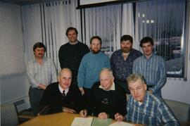
File consists of a photograph commemorating the signing of the first Aleza Lake Research Forest Management Plan. Front row, left to right: Ken Pendergast, BC Forest Service Prince George District Manager; Harry Coates, BCFS Forest Research Technician (1957-1993); John Revel, BCFS Silviculture Forester (1960-1993). Back row, left to right: Mike [?], BCFS Prince George Silviculture Manager; Henry Benskin, BCFS Research Branch; Michael Jull, BCFS Research Silviculturist, Prince George Region; Dan Lousier, BCFS Prince George Region Research Section Head; Brian Harding, Northwood Pulp & Timber Ltd. Woodlands Manager.
Item is a photograph of the S.B. Trick Lumber Co. Sawmill. Image shows men around processed lumber with the mill in the background.
Slide depicts a sawmill in operation, likely located in the Upper Fraser area, with a pile of burning wood products and a beehive burner.
Fonds consists of ledgers recording accounts and maintenance notes of the S. B. Trick Lumber Co. and one photograph of the Ambrose Trick Sawmill.
S. B. Trick Lumber Co.File is a Resource Folio of maps and accompanying information created by Northwood Pulp & Timber regarding Timber Sale Harvesting Licence A01847, Willow River Block, Willow River P.S.Y.U. Includes maps that depict ungulates, waterfowl, recreation areas, special influence areas, and timber types. Most of the sheets have a duplicate, some with very slight variations. The following maps are supposed to be included in the but were missing upon arrival at the Archives: fish & topography, cutting permits & roads, and soils.
File consists of information on the research done at Aleza Lake Research Forest and the history of that research.
File consists of an original and a copy of a BC Forest Service pamphlet entitled "Reforestation in the Central Interior: A glimpse of the past and a view to the future". This pamphlet includes discussion of the Aleza Lake Experiment Station and John Revel's work.
File consists of recreational guides from various places in British Columbia, especially Northern British Columbia. Guides include:
- The North Ridge Ecr-Trail Guide: Aleza Lake Research Forest
- Cluculz Lake Silviculture Demonstration Area: Trail Guide
- Willow River Interpretive Trail
- Crooked River Forest Self-Guided Circle Tour
- Forests for the World Interpretive Trail Guide
- Cottonwood Island Nature Park: Habitat Enhancement.
Slide depicts a burning building at the Aleza Lake Experiment Station on the date it was shut down by the BC Forest Service.
Slide depicts the Ranger Station at the Aleza Lake Experiment Station.
File consists of:
- Original version of Ralph Schmidt's 1993 BC Forest Service publication entitled "The Aleza Lake Experiment Station (1920's and 1930's)"
Series consists of publications created by those associated with the Aleza Lake Research Forest as well as the Aleza Lake Research Forest Society itself. Includes various clippings and articles from serial publications such as newspapers and newsletters that focus on the ALRF. Also includes publications that served as reference material on topics relevant to the ALRF.
Reproduced map on mylar depicts a proposed railway spur for the Aleza Lake Forest Experiment Station.
File contains an original "Proceeding of the Experimental Forests Workshop, April 28-29, 1992" co-published by the Government of Canada and the BC Ministry of Forests. Item is noted to be FRDA Report 202 and BCFRAC Report 2.
File contains an original "Prince George Land and Resource Management Plan" published by the Government of British Columbia.
File consists of "History of the Buckhorn Research Demonstration Area Prince George Forest Region" by J. Revel Nov. 1988 and maps, diagrams, and documentation for:
- Sx 84119G
- Sx 87109G
- EP 976.02.02
- EP 697
- EP 1185
- File also include three large maps: a reproduction of a BC Forest Service Aleza Lake Research Forest map, North Eastern British Columbia Fire Location Map (1961), and map of Summit Lake, Cariboo District B.C. (1966).
Series consists of one black and white photograph of S. B. Trick Lumber Company Sawmill.
Series consists of photographs created or accumulated by the Aleza Lake Research Forest Society.
File consists of a draft of "My History" from "Our Forests can be Sustainable through Research and Silviculture" with handwritten notes on the back of the pages; a page entitled "The foundations of forestry"; and "The Way It Was: the History of Aleza Lake" by Ethelwynn MacArthur.
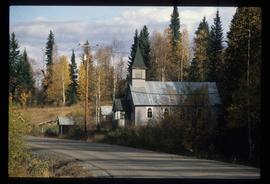
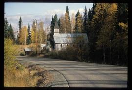
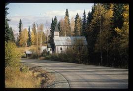
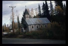
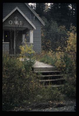
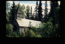
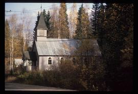
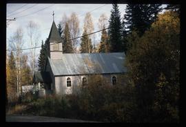
Image depicts the Oblates of Mary Immaculate Catholic Church in Aleza Lake, B.C. Map coordinates 54°07'08.2"N 122°02'00.0"W
Image depicts the Oblates of Mary Immaculate Catholic Church in Aleza Lake, B.C. Map coordinates 54°07'08.2"N 122°02'00.0"W
Image depicts the Oblates of Mary Immaculate Catholic Church in Aleza Lake, B.C. Map coordinates 54°07'08.2"N 122°02'00.0"W
Image depicts the Oblates of Mary Immaculate Catholic Church in Aleza Lake, B.C. Map coordinates 54°07'08.2"N 122°02'00.0"W
Image depicts the Oblates of Mary Immaculate Catholic Church in Aleza Lake, B.C. Map coordinates 54°07'08.2"N 122°02'00.0"W
Image depicts the Oblates of Mary Immaculate Catholic Church in Aleza Lake, B.C. Map coordinates 54°07'08.2"N 122°02'00.0"W
Image depicts the Oblates of Mary Immaculate Catholic Church in Aleza Lake, B.C. Map coordinates 54°07'08.2"N 122°02'00.0"W
Image depicts the Oblates of Mary Immaculate Catholic Church in Aleza Lake, B.C. Map coordinates 54°07'08.2"N 122°02'00.0"W
Image depicts the Oblates of Mary Immaculate Catholic Church in Aleza Lake, B.C. Map coordinates 54°07'08.2"N 122°02'00.0"W
Series consists of tools and materials Harry Coates used during his work as a BC Forest Service Research Technician at Aleza Lake Research Forest. Series also includes awards Harry Coates received during his career.
Large-format map depicts Northwood Pulp & Timber operating areas in 1975.
File contains four maps of the Aleza Lake Research Forest showing locations of Permanent Sample Plots in partial cut timber sales.
Large-format map depicts the Monkman Public Sustained Yield Unit (PSYU) and Tree Farm Licence 30 east of Prince George.
Large-format map depicts the Monkman Public Sustained Yield Unit (PSYU) east of Prince George.
File consists of various documents including:
- plantation charts at McLeod Lake
- notes on lodgepole pine
- notes entitled "A Sustainable Forest for Tomorrow"
- notes on white spruce
- "B.C. Natural Resources"
- E.P. 966 Post-Planting Ecophysiology on Interior Spruce Handout, 92.07.30 Tour
- "The Rise and Fall of Lodgepole Pine"
- Aleza Lake Research Forest "Historic Timber Sales" map (2013)
- "The Need to Develop a Sustainable Forest"
- "1992 N.S.C. Field Tour" Aleza Lake Research Forest"
- Typed notes entitled "Fifty Years of Practical Research - White Spruce and Lodgepole Pine" consisting of brief point-form notes on white spruce, lodgepole pine, and other species
- "E.P. 972.01 The Biological Effectiveness of Mounding and Herbicide Treatments Handout, 92.07.30 Tour"
- Photocopy of page from Appendix II of EP 668
- Edits to text entitled "Forest Management in BC: Evolve or Die" and accompanying email exchange
- handwritten notes
- photocopied pages from E.P. 786.06 and 859.03 report
- correspondence regarding presentation.
File consists of:
- Correspondence regarding the transfer of the Ministry of Forests records related to the Aleza Lake Experimental Station
- Aleza Lake Research Forest research notes on historical records
- Ministry of Forests Records Classifications
- Inventory report of BC Forest Service records relating to Aleza Lake
- Database print-out from the BC Forest Service Prince George Forest Region Research Installation Archive
- Ministry of Forests website print-outs from 2007, including a page on "Research Branch History"


