Six metal storage cases containing primarily slides depicting drill core sections in wooden storage trays. Cases contain inventories of slide images as well as annotations which document the year, drill hole number, and the length along the drill hole from which core sections are taken. In addition to the documentation of drill core sections, the cases contain slides depicting the following subjects: “Representative samples” of drill core fragments, drill core fragments in perspective, “physical characteristics” of the drill cores and the storage trays, the pit mine, a worker in a plaid shirt, close up shots of the geology of the working face, and images annotated “SHOTS OF JADE BOULDER CORE J5-J1”. Five slides originally filed separately and stamp dated “Jul. ‘73” depict what is speculated to be employees working on the diamond drilling project include 2 images annotated ‘R. Dickin Aug ‘72’, ‘I. Oliver Aug ‘73’, ‘S. Zimmer Aug ‘73’, and ‘core shack ’73’. The cases contain 234 7x7cm slides and at least 8 5x5 cm slides which are duplicates of the remaining images. The file also contains a slide strip containing several 7x7 cm slide images.
File contains images depicting various landslides near Cassiar BC. Set of 20 photographs (with 9 corresponding negative strips) date stamped June 1987 depict landslide near creek and dirt road with a Cassiar company truck. Set of 5 black and white photographs found in envelope marked "D. Stewart" are likely from 1988-1989 and depict a rockslide on the south western side of the pit mine, near the tramline. Album entitled “6200 DUMP SLIDE / SPRING, 1979” contains 34 photographs depicting aerial shots of a massive rockslide on the eastern slope of McDame Mountain, originating from the mine waste dump. Several images from album show greenish water pooling in the toe of the slide.
File contains images of mine operations and construction, as well as a variety of other subjects.
- Elements of the underground mine are depicted, including miners working, the marked rock face, yellow ducting and ventilation fan, the portal, mesh rockbolted onto adit walls, shotcrete being applied, and stacked mining construction materials.
- Mining equipment depicted in this file includes underground ore haulage truck, Wabco ore haulage truck, jackleg drill, stoper drill, scoop tram, jumbo drill, conveyor, pickup trucks, unidentified mixing or grinding machine, a cable wagon and half constructed ore haulage truck in the shop, and a continuous miner (also known as alpine miner or roadheader).
- A set of images show a dozer and a lowbed truck transporting a temporary building down the pit mine access road.
- Several images depict drill core fragments, asbestos ore, and geological features of the mine.
- Mining related process are depicted, including a young man sluicing and panning, a mine building under construction, and an unidentified steel frame structure with a hydraulic device suspended on a rail.
- A set of images shows a railway or highway construction project, including stockpile of construction materials, rail cars, caboose, locomotive, front end loader, dump truck, concrete mixing trucks, semi-trucks, and a rail car with large steel drums which are speculated to be specialized for tunnel construction.
- Further images show what is speculated to be tunnel construction.
- A set of images at a high ceiling underground mine which is not Cassiar depicts a man in a suite by a underground ore haulage truck, and other mining vehicles including a crane.
- A set of images depict an ungulate herd, possibly bighorn sheep, on a mountain side.
- The file includes several images which depict personal life, presumably from a family vacation, and access to these images may be restricted. These images depict man with children on a fishing trip, adults and children around a pool, a woman on a motorcycle, and a house and kitchen. Several groups of images are contained in envelopes annotated with dates and “K. Minty”.

Photograph depicts the North peak of McDame mountain in the earlier stages of strip mining, South peak unmined in background. Quonset and other shops visible in left foreground, unknown building built into mountainside in right foreground.
Photograph depicts the pit mine, and road in valley below. Town of Cassiar can be seen in distance at foot of south mountain range.
Photograph depicts view of mine, mountain range in background.
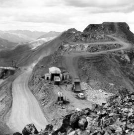
Photograph depicts the Cassiar mine, switchback road in foreground, mountain range in background. Pit is visible behind the West peak. The new mine garage can be seen on West peak just above "#7 switchback" in centre of image.
Photograph depicts the Cassiar mine to right of mine valley, north mountain range in background. Tramline station visible on west of open pit, and the new mine garage can be seen behind the West peak.
Photograph depicts benches above open pit at Cassiar mine. Drills and haulpaks visible in centre image.

Photograph depicts two pick hammers laid in asbestos fibre. Annotations on note glued to recto of photograph: "ASBESTOS"; "Detail view of asbestos talus. Early test pit near top of showing. Western slope." Areas of image have been labeled "A" and "B". Photo caption under printed copy of image in 1952 Annual Report: "A - Asbestos fibre partially opened by frost action. B - Serpentine rock originally containing the asbestos fibre."
File contains photographs depicting machinery, individuals, buildings, and mining processes at the open mine on McDame Mountain, Cassiar, B.C. Some photos depict benches from open strip mining, and two images feature models of the mine (1955 and 1970). Machinery depicted includes shovels, bulldozers, tractors, ore haul trucks (Kenworth, International Harvester, and Wabco), air track drills, blasthole drills, and Ingersoll-Rand Drill. Identified individuals include Fred Murray, R.R. [Kiresan?], C.E. Bronson, Bill Giachino, and "Sam".

Photograph depicts a man and woman standing on what is believed to be an early mining bench. Two men with air track drill can be seen in background, one man father down on left, mountain range in background. Image slightly distorted due to poor quality of negative.

Photograph depicts two men working with air track drill in mine area. Hose and dynamite box in foreground, mountains in background. Handwritten annotation on verso of photograph: "Sept. 1954." This photograph was originally stored inside duotang labeled "CASSIAR ASBESTOS CORPORATION LIMITED PHOTOGRAPHS 1954"; photo caption beneath this image: "Starting New Bench at South end of Deposit."
Photograph depicts what appears to be a small model of projected bench mining on McDame mountain. The model stands outdoors on small wood table, car partially visible in background. Annotation printed in border on verso of photograph: "1955."
Photograph depicts two men standing to left of Fred Murray on balcony of large building or structure speculated to be in the Cassiar valley. Portion of log structure in left foreground, man and hauling trucks on road in background.

Photograph depicts unknown man driving bulldozer on edge of mine area at high elevation. The dozer is an International model TD24 (manufactured between 1947 and 1955). A second man stands on edge of cliff, directing driver. Expansive mountain range in background.
Photograph depicts two blasthole drills on bench in mine, old garage visible in centre background. Snow-covered mountain range in background.
File contains photographs featuring:
- the pit mine: fault line, geology, snowdrifts, plowed snow, blast patterns marked by orange cones, mist, and surrounding mountains.
- Pit mine is depicted by aerial photographs and a profile diagram.
- Several photographs also depict what is speculated to be the portal to the underground mine adit in the early phases of development.
- One photograph depicts the shop building in the pit mine, used for maintenance of mining equipment and to house the primary crusher.
- Several photographs show office interiors and personnel and it is speculated that these photographs were taken in the upper floor of the shop building.
- Several photographs depict small sinkholes in the pit mine.
- Mining equipment depicted includes pickup trucks, front end loaders (including a Cat 988), ore haulage trucks, scoop trams, D8 Caterpillar dozer, grader, mining drill rig, jumbo drill, rock hammer, P&H excavator, and wireline extensometer. Photolab envelopes accompanying these materials were annotated “R. Tyne” and “falling ground”. Slide sleeves were annotated “Mine Nov-Dec 1975”, “AERIAL SHOTS OF MINE 1976” and “Phase 8 Dec 1975”.
- Photographs of a Gardner Denver blasting drill at the mine and other ground drills working
- Photograph of proposed power line to #1 switchback in 1975,
- Collection of photographs of a Wsbco truck with corresponding mechanical transfers of those photographs.
- Also photographs a Gardner Denver drill and a Bucyrus Erie drill that was rented to Cassiar Mine in 1974. This collection includes a depiction of an accident with these drills.
- An additional collection of photographs of #709 Drill that was involved in minor accident. A pipe was either damaged or was the cause of the accident.
- Negative collection of photographs with corresponding notes of descriptions.
- Photographs of G.D. 80 Drill - Blasthole drill at work in the open pit.
- Photographs part of Month End Reports from January - June 1980
- Photographs of portable toilets used on Mine site.
- Photograph collection of mine garage January 21, 1988
- Photograph collection of what is believed to be the inside of the mine garage and various storage units and equipment. Marked "Receiver File" in original enclosure.
- Photos of Crane in 1984.
- An Album of 192 photographs of machinery in March of 1976 working at the mine site. Some of the equipment from either the plantsite or the mill is also depicted.
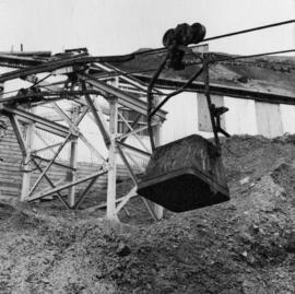
Photograph depicts bucket hanging from tramline in foreground. Support tower stands in midground in front of station building. Another building can be seen at top of mountain in background. Handwritten annotation on recto of photograph: "INCOMING BUCKET #1 STATION". Photograph was glued to cardboard backing with the annotation: "1962".
Photograph depicts a car and two dump trucks near a small garage by road in mine. One man stands at garage site among tires and miscellaneous tools. Blasthole drills, shovels, and dump trucks visible in distance. Rocks in foreground, mountains in background. Handwritten annotation on verso of photograph: "1961".
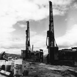
Photograph depicts men standing near two Atlas Copco Drillmasters (blasthole drills). These are precision hammer drills which had their own power source. Large bags of ammonium nitrate in foreground, mountaintops in background. The men depicted here were likely members of the explosive crew. It is believed that this photo was taken on the North ridge, near the cirque dump. Handwritten annotation on verso of photograph: "1961".

Photograph depicts tower and bucket tram in left foreground, plantsite in midground, mountains across valley in background. Dry rock storage building, mill, tailings pile, and many other buildings visible in plantsite. Handwritten annotation on verso of photograph: "1961".
File contains photographs taken for promotional purposes.
- Two photos depict a Cassiar display at an unknown event in 1963.
- Eight photos were professionally taken for use in the 1978 Cassiar Asbestos Corportaion Ltd. Annual Report, and possibly other publications. These photos depict a skyscraper and products made with asbestos.
- Additionally, two hand painted postcards of McDame Mountain and Christmas Tree House are included that may have been used for promotional reasons. Also, four slides of a display, "Story of Asbestos."
- five photographs of unofficial tour of Cassiar via airplane in the 1970s.
This map depicts a drawn bench plan for the estimated excavated waste for bench 6440 during the first quarter of 1972. Annotated details include the approximate excavated ore tonnages, broken and planned values for the first quarter and revised calculations from previous years values. Planned excavated areas are drawn with different colors.
This map depicts the generalized pit layout and estimated waste extraction areas for 5810 bench. Annotated details include numerical bench markers, extraction dates and approximate ore extraction amounts. The hand drawn plan consists of solid and dotted lines drawn with green, orange and lead pencil.
This map depicts the pit layout and estimated waste extraction areas for 6320 bench for the end of September to October. Extraction dates are included within certain portions of the plan. Annotated details include numerical bench markers, extraction dates, and approximate waste tonnage calculation for October. The hand drawn plan consists of solid and broken lines drawn with red, orange and lead pencils as well as black ink.
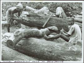
Item is a photograph of two men swede sawing a log.
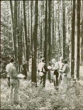
Item is a photograph of from left, Ralph Robbins and Jack Paine of the BC Forest Service, Ray Williston, Chief Forester for Canadian Forest Products Tom Wright, Deputy Minister of Forests Finley McKinnon, Canadian Forest Products Vice-President in Charge of Development John Liersch, and BC Chief Forester John Stokes investigating small wood in an area near Prince George.
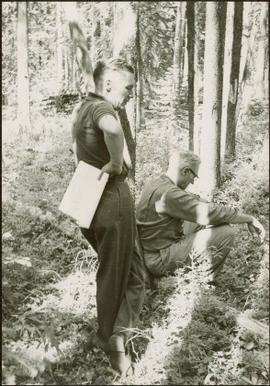
Item is a photograph of Ray Williston and John Liersch in a small wood area southwest of Prince George.

Photograph depicts a miner spraying enclosed area of river bed with water at high velocity. Cliffs in background.
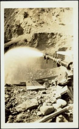
Photograph depicts water being sprayed from a pipe at high velocity over edge in mining area. Man's leg in foreground, cliffs in background.

Photograph depicts water being sprayed from pipes at high velocity in mining area. Unidentified man in midground, cliffs in background.
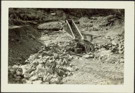
Photograph depicts a large structure in center of mining area in riverbed, equipment and supplies scattered throughout. Buildings and forest in background. Handwritten annotation on verso of photograph: "Spruce Creek, Lower Shovel Workings 6/25/39.", on recto: "Atlin".

Photograph depicts two log buildings in fenced area on lake shore, forest trees in background. A man can be seen standing near docking area and small boat pier extending into water in foreground. Handwritten annotation on recto of photograph: "Fur Farm Red Rock Lake". This location is believed to at mile 27, north of Summit Lake.
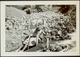
Three unidentified women lean over flowing stream in area speculated to be a mining location. Sluiceway appears to be visible in foreground.
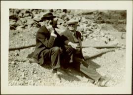
Glassey sits on ground with unknown man in area believed to be a mining location, rocks and logs in background.
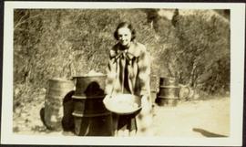
Unidentified woman holds pan in area speculated to be a mining location. Steel drums stand behind her, road and grassy hillside in background.
This photograph album consists of photographs of remote police barracks at Mile 47 and Mile 29; early settlements and/or mercantile stores at Tete Jaune Cache, McBride, Sand Creek, Fort George and South Fort George; Grand Trunk Pacific Railway forestry and railway camps; scows and paddlewheel conveyors on the Fraser River; automobiles; community leisure activities; as well as, images of the Bourchier family. The following South Fort George establishments are identifiable within these photographs: Empress Hotel, Ah Yee General Merchant, German Bakery, Northern Hotel, South Fort George Drug Store & Post Office, St. Michael’s Church, Prince George Hotel, Ford Monarch dealership, Astoria Hotel, and King George V Elementary School. Identified geographic locations featured in these photographs include: Tete Jaune, Upper Fraser, Mile 47, Mile 29, Fraser River, Mt. Robson, McBride, Sand Creek, Glacier Mountain, Moose River, Giscome Portage, Pott Falls, Red Deer River, Grand Canyon, Summit Lake, Canoe Pass, Connaught Hill, Nechako Bridge, and Island Cache.
Sans titre
Photograph depicts three men standing with oars in small boat, forest slash at their feet. More slash lies in foreground behind bushes and plants on swampy shore. Trees in background. These men are believed to be members of the Bourchier forestry crew.

Photograph depicts an empty canoe floating directly in front of small white tents on opposite shore. Forest trees in background.

Photograph depicts men on river boat and small canoe floating just off shore. Men sit and stand on shore among square bales and large cut lumber. Forest in background. Handwritten annotations on recto of photograph: "Fort Fraser wooding up at Giscome Portage", "Chilco at Giscome Portage".
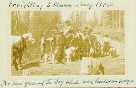
Photograph depicts four men and five sled dogs standing beside a horse-drawn wagon loaded with dog sleds with a forested landscape in the background.
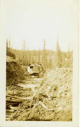
Photograph depicts a gas (?) shovel digging a ditchline through a forested area.
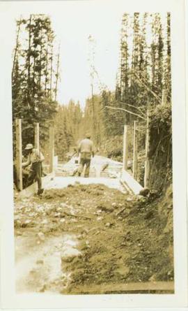
Photograph depicts two unidentified men working on a wooden flume located in a forested landscape. Handwritten annotation on verso of photograph states: "flume".
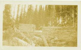
Photograph depicts three piles of stacked lumber located in a forested landscape. Annotation on verso of photograph reads: "Lumber for flumes. Co. has its own sawmill"
Subseries consists of correspondence relating to the Department of Environment (Environment Canada), the Department of Fisheries and Oceans (Fisheries and Oceans Canada), and environmental issues. Includes correspondence regarding Ministry of Environment programs and procedures; the Canadian forestry industry; forestry licenses; pollution and legislation controls for industry pollution; oil spills; polychlorinated biphenyl pollution; floods and flood control mechanisms; dams and stream diversions; trapping legislation; and wildlife conservation. Also includes correspondence regarding inquiries intro fisheries management legislation and policies; fisheries licensing; salmon fisheries issues; inquiries and statements of opinion about the yearly seal hunt; whale conservation; the economic zone off-shore fishing limits; small craft harbours; sport fishing; and the roe herring fishery. Contains speeches given by the Minister of Environment or given on his behalf and news releases from Fisheries and Oceans Canada.
File consists of a 33 paged report on the history of the Columbia Cellulose Company, Limited as of August 20, 1959.
With support from the Muskwa-Kechika Trust Fund as a Seed Grant, Dr. Paul Sanborn carried out a pilot study of soils in relation to prescribed burning in the Northern Rocky Mountains, in collaboration with Perry Grilz, then a Range Officer in the Ministry of Forests. Sanborn and Grilz conducted 3 days of field work in July 2001. Sanborn wanted to test the utility of plant-derived opal (phytoliths) as a soil indicator of vegetation history, in the hope of distinguishing natural grasslands from those created by anthropogenic burning.
This map depicts the pit layout and estimated waste extraction areas for 6380 bench. Extraction dates accompanied by its total tonnages are located within each planned area. Certain extraction dates are labeled with bench numbers. Annotated details include extraction dates, approximate total tonnages per area as well as extraction dates, total planned and broken tonnages, total tonnages from December 31, 1970 from a survey done in September 1, numerical bench markers as well as a rough colored legend depicting extraction month by color. The hand drawn plan consists of solid lines drawn with green, yellow, red and lead pencils.
This map depicts the pit layout and estimated waste extraction areas for 6320 bench. Extraction dates accompanied by its total tonnages are located within each planned area. Certain extraction dates are labeled with bench numbers. Annotated details include extraction dates, approximate total tonnages per area accompanied by extraction dates, total planned tonnages, total tonnages from December 31, 1971 as well as a rough colored legend depicting extraction month by color. The hand drawn plan consists of solid lines drawn with green, red, orange and lead pencils.