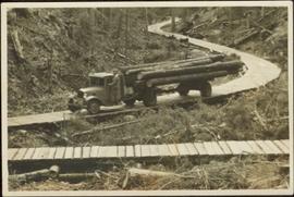
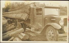
An “Indiana” flatbed logging truck releases logs from its load onto a makeshift log slide at the edge of a road.
Handwritten annotation in pencil on verso: "unloading logs".
An “Indiana” flatbed logging truck releases logs from its load onto a makeshift log slide at the edge of a road.
Handwritten annotation in pencil on verso: "unloading logs".
Overhead photograph of Giscome with the Eagle Lake Sawmill's beehive burner clearly visible in left foreground. Handwritten annotation in pen on verso reads: “Part of our community. school * ”
Street view featuring a dirt road leading directly to Giscome School, a three room institution. On the right the steeple of the Catholic church is visible, beside which was Neff’s (sp?) corner store. Handwritten annotation in pen on verso reads: “Looking up our street. The school is at the end.”
Closeup of Giscome School. Handwritten annotation in pen on verso reads: “Our school. This is my 0 room – the back of it.”
Elevated class photo featuring 28 students of grade 3, 4 and 5 posing for an outdoor photo in a field of grass. Wooden support for swing set visible to the left.
Some of the children from Division II standing for a group photograph in front of a wall displaying their work.
Side perspective of St. Frederick’s Catholic Church located on Brown Ave. in Giscome. Handwritten annotation in pen on verso reads: “The Catholic Church, St. Frederick.”
Small wooden outhouse with wooden planked pathway sits in an open field behind the Teacherage. Handwritten annotation in pen on verso reads: “Behind the teacherage. Guess what?”
Side perspective of the teacherage located on Brown Ave. in Giscome. Photo taken in November after the first snow. Handwritten annotation in pen on verso reads: “Our House.”
Photo displays the height of the snow on the front porch of the Giscome teacherage after a blizzard.
Side perspective of Knox United Church in winter. Handwritten annotation in pen on verso reads: “The United Church.”
File consists of a transcript of an oral history interview with Horst Sander. Also includes photocopies of Horst Sander's personal records, such as a tree farm license.
File consists of a transcript of an oral history interview with John and Bernice Trick.
File consists of a transcript of an oral history interview with Kate Anderson and Mae Romanin.
File consists of a transcript of an oral history interview with Heather (Scott) Empey.
File consists of an audio recording of an interview with Lea Gobbi and Kate Anderson. Includes two original recorded audio cassettes and two copies.
Image depicts an open area with Eaglet Lake in the background. It depicts the previous site of the mill at Giscome, B.C. Map coordinates 54°04'19.7"N 122°22'04.7"W
Image depicts the Giscome B.C. townsite from across the railroad tracks looking southeast. Map coordinates 54°04'19.7"N 122°22'04.7"W
Image depicts the Giscome mill site in Giscome, B.C. The bunkhouse is in the background on the left and the school is in the foreground on the right. Map coordinates 54°04'04.8"N 122°22'04.7"W
Image depicts the Giscome mill site in Giscome, B.C. The bunkhouse is the large building with many windows. A train and railroad tracks are in the foreground. Map coordinates 54°04'17.6"N 122°22'06.1"W
Image depicts employee houses on mill site in Giscome, B.C. Tug boats are in the foreground on the right. Map coordinates 54°04'23.4"N 122°22'16.9"W
Image depicts a street of houses in Giscome, B.C. Map coordinates 54°04'20.9"N 122°21'53.1"W
Image depicts the remains of a street of houses in Giscome, B.C. The quarry is slightly visible in the background. Map coordinates 54°04'20.9"N 122°21'53.1"W
Image depicts a church in Giscome, B.C. Map coordinates 54°04'16.2"N 122°21'54.3"W
Image depicts several houses and the Giscome saw mill in Giscome, B.C. in the background. Map coordinates 54°04'20.9"N 122°21'53.1"W
Image depicts the mill site at Giscome and its beehive burner. Map coordinates 54°04'19.7"N 122°22'04.7"W
Image depicts a Catholic church in Giscome, B.C. Map coordinates 54°04'15.5"N 122°21'52.1"W
Image depicts the creek flowing into Eaglet Lake. A grey area of hill on the right side of the image appears to be the Giscome Quarry. Map coordinates 54°04'26.2"N 122°22'04.3"W
Image depicts a farm in Giscome, B.C.
Original photographic print included in "Northern Interior Forest Experiment Station: Report of Preliminary Investigations" by Percy Barr. Photograph depicts mature spruce and balsam reproduction.
Man driving a two horse cart in front of beehive burner, cart is full of bark presumably sawed off the logs.
Handwritten annotation in pencil on verso: "Mill Burner".
Six men visible on hillside and wood plank roadway, working together to roll cut logs down the hill and load them onto the truck.
Handwritten annotation in pencil on verso read: “logs up to 32 feet in length.”
Fully loaded logging truck driving along a switchback, wood plank logging road.
Handwritten annotation in pencil on verso reads: “Truck Logging / Giscome BC.”
Fully loaded logging truck driving along a wood plank logging road. Another road under construction is also visible through forest in background.
Overhead photograph of Giscome buildings with Eaglet Creek running through the foreground. Handwritten annotation in pen on verso reads: “Notice the flatness of the land. Part of our community.”
Head on class photo featuring 28 students of grade 3, 4 and 5 posing for an outdoor photo in a field of grass. Wooden support for swing set visible to the left.
Photograph taken from the back of the classroom. Handwritten annotation in pen on verso reads: “In the classroom.”
Side perspective of Knox United Church located on Brown Ave. in Giscome. Handwritten annotation in pen on verso reads: “United Church.”
Side perspective of the teacherage located on Brown Ave. in Giscome. Photo taken in September. Handwritten annotation in pen on verso reads: “The Teacherage.”
Handwritten annotation in pen on verso reads: “Looking out of our classroom window up the street.” According to the donor, the car stuck in the snow belonged to his colleague, Bob White.
Image depicts a field in Giscome, B.C. On the right side of the image, in the background, is a grey strip that appears to be a mine, possibly the quarry at Eaglet Lake in Giscome, B.C. Map coordinates 54°03'52.9"N 122°22'10.0"W
Image depicts the Giscome B.C. townsite from across the railroad tracks looking southeast. Map coordinates 54°04'19.7"N 122°22'04.7"W
Image decpicts the old road to the townsite in Giscome, B.C. Map coordinates 54°04'19.7"N 122°22'04.7"W
Image depicts a house with the main floor and entrance high off the ground. The location is uncertain, likely Giscome, B.C.
Image depicts a large, old and collapsing barn, as well as a nearby house of the dairy farm in Giscome, B.C. Map coordinates 54°03'53.3"N 122°21'22.6"W
Image depicts the former location of employee houses on mill site in Giscome, B.C. Map coordinates 54°04'23.4"N 122°22'16.9"W
Image depicts the old CN station in Giscome, B.C. Map coordinates 54°04'20.7"N 122°22'01.1"W
Image depicts the Giscome mill foreman's house on the hill, with Eaglet Lake in the background and numerous piles of logs in the foreground. Map coordinates 54°04'28.0"N 122°22'05.8"W
Image depicts the mill site at Giscome, B.C. Map coordinates 54°04'19.7"N 122°22'04.7"W
Image depicts the mill site at Giscome, B.C. A sign in the foreground reads "Maynard's Industrial Auctioneers." Map coordinates 54°04'19.7"N 122°22'04.7"W