Previsualizar a impressão Fechar

Mostrar 62 resultados

Archival description
53 resultados com objetos digitais Mostrar resultados com objetos digitais
Alaska Highway Construction Album
2024.06 · Coleção · 1942

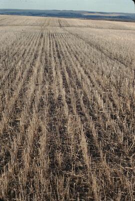
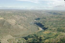
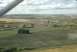
Photograph album contains 134 snapshots showcasing building activity, equipment, logging, and airplanes in British Columbia and the Yukon, taken during the building of the Alaska Highway in 1942. The photographer is unknown. Many of the photographs depict Fort St. John and Fort Nelson.

Some of the photographs are captioned as follows:

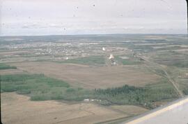
  • Looking north at Fort St. John, B.C.
  • P.R.A. Bellanea and Army Norseman sea-planes on Charley Lake near Fort St. John, B.C.
  • Looking toward outlet of Muncho Lake from Float Plane
  • Fort St. John, British Columbia. Canada
  • Colonel Ingalls’ bridge across Liard River
  • Post Office & Government Telegraph Office
  • P.R.A. Camps at Fort St. John, B.C. looking N.E.
  • Post Office & Government Telegraph Office - Fort St. John - 1942
  • Army Ferry on Peace River near Taylor's Flats
  • Looking west on Main Street, Fort St. John, B.C. May - 1942
  • Looking southwest across Summit Lake
  • Public Roads Administration Headquarters Buildings. Fort St. John, B.C. - April - 1942
  • Looking southwest from south bank of Peace River from Old Highway near Taylor Flats, B.C.
  • First Army Headquarters - Fort St. John, B.C. - 1942
  • Beginnings of Fort Alcan - May 1942 - Fort St. John, B.C.
  • Road between 101 and 157
  • Other side Muncho Lake
  • Big Black Bear
  • Liard River, Canada
  • Dog Sled. Muskwa River
  • Temporary Bridge at Muskwa, B.C.
  • Another bridge in British Columbia
  • Above Fort Nelson, B.C. White spot in picture is the “moon”
  • Mountains N-106
  • Coughlin’s equipment at work west of Fort Nelson - Nov. - 1942
  • Near Mile Post 175-N descending to shore of Muncho Lake
  • First Fairbanks sign erected in Fort St. John. Apr. 1942
  • Boat used to cross the Fort Nelson River at Fort Nelson
  • Typical P.R.A. Engineers Camp at Mile 84-N
  • Fort Alcan - near St. John. British Columbia. “1942.”
  • Captain Hinze and Army beachcraft used on Army reconnaissance surveys for Alaska Highway
  • Small single motored aircraft used by P.R.A. on Alaska Highway Reconnaissance flights forced down on Gravel Bar on the Laird [sic] River near Mile 313-N
  • Near Mile 173-N looking at outlet of Muncho Lake
  • Near Mile 145 N. Toad River looking downstream
  • Looking southwest at Muncho Lake at Army operations on shore Pioneer Road. First tote road may be seen above.
  • Hudson Bay Store at Dease Lake, end of truck portage from Telegraph Creek + Wrangell. Beginning of boat freighting to lower port
  • Mile 104 n. Sugarfoot Lake
  • Mile 104 N. Sugarfoot Lake
  • Looking north from Mile 140 N. at Folding Mountains - approx. 8,000 ft high
  • Army forces along Muncho Lake
  • Malamute sled dog at Fort Nelson
  • P.R.A. location. Engineers’ Camp near Mile 165-N
  • Few miles west of Ft. St. John looking downstream at Peace River. Old Fort St. John. Buildings on near shore
  • British Columbia Police Plane in Fort Nelson River at Fort Nelson, B.C.
  • Few miles west of Fort St. John - Looking across Toad River at Little Folded Mountain near Mile 141
  • Looking northwest at P.R.A. an Oakes Camp and Alcan Highway.
  • Clouds after a rainstorm over Teslin Lake, Yukon Territory between Watson Lake and Whitehorse.
  • Toad River and Big Folded Mountain near Mile 142 N
  • Teslin Lake between Watson Lake & Whitehorse Y.K. The lake is 72 miles long
  • Whitehorse, Yukon Territory
  • Dept. of Transport Ferry on Peace River near Taylor Flats.
  • Foothills east of Rocky Mountains between Watson Lake & Whitehorse, Yukon Territory
  • Public Roads Administration (P.R.A.) Camp at Whitehorse, Y.K.
  • Whitehorse end of the White Pass and Yukon Railway from Skagway, Alaska to Whitehorse, Y.K.
  • Husky sled dog. Ft. St. John, B.C.
  • Mile 103 N. Looking east at Army Camp at Mile 102 N. - Summit Lake
  • Opening of new bridge on Sikanni River
  • Peace River Bridge has now replaced this “Ferry” - Fort St. John, B.C
  • Muskwa River new Fort Nelson, B.C.
  • Bridge across the Muskwa River.
  • View of mountains across flat between 101 - and 157
  • Plane at Fort Nelson - Ft. Nelson River
  • Moose Calves
  • Suicide Hill - J 108. Now eliminated from Alaskan Highway
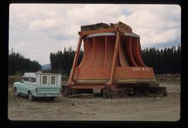
  • Road Construction Equipment Center Boom - Bulldozer and Side Boom
  • Center Boom. Taken at Water Line
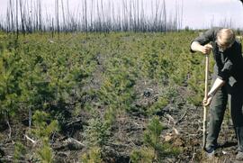
  • Early stages of road construction
  • Bulldozing for the Highway
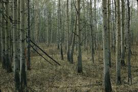
  • Clearing the tinder for the Highway
  • Convoy of trucks on Alaskan Highway
  • Repair Camps off Highway
  • Mud - Mud - Mud - Mud!
2020.4.6.162 · Dossiê/Processo · 1986
Parte de G. Gary Runka fonds

File consists of records created and accumulated by Gary Runka over the course of his consultancy work with Don Ference and Associates for Indian and Northern Affairs Canada for the "Analysis of Sequential Land Use Change - IR#172 (Montney Reserve)" project in relation to the legal case Apsassin et al v. Her Majesty. This file was numbered as G.G. Runka Land Sense Ltd. client file #162; that client number may be seen referenced elsewhere in the G. Gary Runka fonds. Includes correspondence, invoices, photocopied map areas, handwritten notes, photocopied legal documents, and photocopied government documents.

Includes the following:

  • Photocopied history and compilation of government documents by A.F. Honner relating to the history of the St. John Indian Reserve, 1961
  • Photocopied version of a report entitled "Peace River Agricultural Land Valuation" prepared by the Department of Finance, 1954.

Maps include:

  • Canada Department of Agriculture, "Canada Land Inventory, Land Capability for Forestry - Fort St. John, British Columbia, Peace River Land District - 94 A/SE", 1973.
  • Reproduction of BC Land Registry, "Plan of Subdivision of St. John Indian Reserve No. 172 Peace River District", Plan 3986, 1947.
  • Agriculture Canada, "Soils of Fort St. John-Dawson Creek Area, British Columbia, Soil Survey Report No. 42", 1985.
  • BC Ministry of Environment, "Climatic Capability for Agriculture - Fort St. John", 1983.
  • Reproduction of NTS map of "North Pine, British Columbia" with annotated overlay. Date of base map 1956, date of overlay unknown.
  • Reproduction of NTS map of "North Pine, British Columbia sheet 94 a/7 East Half" with annotated overlay. Date of base map 1956, date of overlay unknown.
  • Reproduction of Canada Land Inventory Ungulate Capability for Fort St. John 94 A/SE, [197-?]
  • NTS "Charlie Lake, Peace River Land District 94 A Edition 3", 1985.
2020.4.6.079 · Dossiê/Processo · 1982
Parte de G. Gary Runka fonds

File consists of records created and accumulated by Gary Runka over the course of his consultancy work for BC Ministry of Lands, Parks and Housing for the "Moberly DPA" project in Fort St. John. This file was numbered as G.G. Runka Land Sense Ltd. client file #079; that client number may be seen referenced elsewhere in the G. Gary Runka fonds. The Land Sense Ltd. client files generally include records such as correspondence, contracts, invoices, project reports, publications, ephemera, memoranda, maps or map excerpts, legal documents, meeting materials, clippings, and handwritten notes.

Maps include:

  • "Moberly River" NTS map annotated with Soils & Landforms;
  • "Moberly Crown Land Plan Area - Land Capability for Agriculture Interpretation" by G. G. Runka Land Sense Ltd., 1982;
  • "Hudson Hope" 1964 NTS map annotated with Soils & Landforms;
  • "Moberly Crown Land Plan Area", n.d. - 2 copies;
  • "Climate Capability for Agriculture 94A-SW", 1970.
2020.4.6.066 · Dossiê/Processo · 1982
Parte de G. Gary Runka fonds

File consists of records created and accumulated by Gary Runka over the course of his consultancy work for BC Ministry of Lands, Parks and Housing for the "Fort St. John North Deferred Planning Area (DPA)" project. This file was numbered as G.G. Runka Land Sense Ltd. client file #066; that client number may be seen referenced elsewhere in the G. Gary Runka fonds. The Land Sense Ltd. client files generally include records such as correspondence, contracts, invoices, project reports, publications, ephemera, memoranda, maps or map excerpts, legal documents, meeting materials, clippings, and handwritten notes. Includes the "Fort St. John North Deferred Planning Area for the Ministry of Lands, Parks & Housing, Peace Region - Final Report" by Talisman Land Resource Consultants, April 1983. File also includes 173 accompanying aerial photographs.

Trail Maps and Recreation Guides
2016.5.5.01 · Dossiê/Processo · [19-?]
Parte de Harry Coates fonds

File consists of trail maps and recreation guides from various places in British Columbia, especially Northern British Columbia. Maps include:

  • British Columbia Road Map and Parks Guide
  • Northwood Pulp and Timber Limited Forest Operations Recreation Map
  • Provincial Parks of Northern British Columbia
  • Visitor's Guide: Mackenzie Woodlands
  • Visitors Guide: Mackenzie Woodlands
  • Mackenzie Forest District Recreation Map
  • Dawson Creek Forest District Recreation Map
  • Morice Forest District Recreation Map
  • Fort St. James Forest District Recreation Map
  • Lakes Forest District Recreation Map
  • Cariboo Forest Region Recreation Map
  • Lakes District Visitors Map
  • Prince George Forest District Recreation Map
  • Vanderhoof Forest District Recreation Map
  • Fort St. John Forest District Recreation Map
  • Cariboo Forest Region Recreation Map (East)
  • Robson Valley Forest District Recreation Map
  • Fort Nelson Forest District Recreation Map
  • Forest Service Recreation Sites: Valemount - Blue River
  • Forest Service Recreation Sites: McBride - Goat River
  • Forest Service Recreation Sites: Prince George West
  • Forest Service Recreation Sites: Moberly - Sukunka
  • Forest Service Recreation Sites: Nation - Takla
  • Forest Service Recreation Sites: Murrat - Kiskatinaw
  • Recreation Road Map for the Prince George Forest Area (1987-1988)
  • Recreation Road Map for the Prince George Forest Area (1997)
  • The Bobtail Forest Service Road Tour
  • Forest Recreation Map: Northwood Pulp and Timber Limited
  • Forest Operations Recreation Map: Northwood pulp and timber limited
  • Forest Service: Recreation Sites Williston/Mackenzie
  • Forest Service Recreation Sites Prince George West
  • The Official Prince George Tourist Street Map
  • Ecological Reserves in British Columbia (July 1990)
  • Prince George Forest District map (April 1990) with annotations regarding trials.
Observatory Window
2012.13.1.93.53 · Item · 1978
Parte de J. Kent Sedgwick fonds

Image depicts a group of unidentified individuals look through an observatory window at an uncertain location, possibly in Fort St. John, B.C.

Computer Room?
2012.13.1.93.52 · Item · 1978
Parte de J. Kent Sedgwick fonds

Image depicts what appears to be a computer room at an uncertain location, possibly in Fort St. John, B.C.

Large Metal Cylinder
2012.13.1.93.51 · Item · 1978
Parte de J. Kent Sedgwick fonds

Image depicts a piece of machinery shaped like a large metal cylinder. It is possibly located somewhere in Fort St. John, B.C.

Inside Machinery
2012.13.1.93.50 · Item · 1978
Parte de J. Kent Sedgwick fonds

Image depicts two individuals at work inside what appears to be a piece of machinery. It is possibly located somewhere in Fort St. John, B.C.

Fort St. John? - Concrete Building Interior
2012.13.1.93.44 · Item · 1978
Parte de J. Kent Sedgwick fonds

Image depicts two unidentified individuals in hard hats leaning against the railing of a large, open space inside an unknown concrete structure. It is possibly located in Fort St. John, B.C.

Peace River
2012.13.1.93.36 · Item · 1978
Parte de J. Kent Sedgwick fonds

Image depicts the Peace River, possibly somewhere near Fort St. John, B.C.

Bare Trees
2012.13.1.93.35 · Item · 1978
Parte de J. Kent Sedgwick fonds

Image depicts a forest of bare trees, possibly somewhere near Fort St. John, B.C.

Group and a Bus
2012.13.1.93.34 · Item · 1978
Parte de J. Kent Sedgwick fonds

Image depicts a group of individuals and a bus with words that read: "Prince George Limousine & Charter." The river in the background is possibly the Peace River, and the location is possibly somewhere near Fort St. John, B.C.

Fort St. John? - Old Farm Equipment
2012.13.1.93.29 · Item · 1978
Parte de J. Kent Sedgwick fonds

Image depicts numerous pieces of what appears to be old farming equipment. There is also an unidentified individual sitting aginst the side of a building. The location is possibly Fort St. John, B.C.

Fort St. John
2012.13.1.91.03 · Item · Sep. 1974
Parte de J. Kent Sedgwick fonds

Image depicts an area of forests and fields somewhere near Fort St. John, B.C.

Fort St. John - Turbine
2012.13.1.51.140 · Item · Sep. 1979
Parte de J. Kent Sedgwick fonds

Image depicts an unknown individual standing next to a turbine located somewhere in Fort St. John, B.C.

Articles and papers written about Knox McCusker
2008.27.3 · Dossiê/Processo · 1935-1997
Parte de Knox McCusker Collection

File consists of the following items:

  • "Mac" by D.L. Surveyor
  • "Knox (Mac) McCusker: Dominion Land Surveyor" by E.L. Rutherford, V.C. Brink, R.S. Silver and M.Z. (Smokey) Neighbour
  • Excerpts from Men and Meridians by Don W. Thomson
  • Article re: Knox McCusker written on the occasion of his death (April 14, 1955)
  • "McKusker (sic) to open up Blueberry Mountain Area" (Alaska Highway News, June 8, 1950)
  • "McCusker was surveyor, big game guide….also rancher and trail blazer"
  • "Knox Freeman McCusker" written on the occasion of his death (The Canadian Surveyor, July 1955)
  • "Veteran Surveyor - Alaska Highway Stories"
  • Memories of Knox McCusker by his oldest niece Betty (McCusker) Rutherford
  • "Veteran Surveyor prefers horses for long bush treks" by Eric Young (Edmonton Journal)
  • Eulogy for Knox McCusker read by Stanley D. Seif at Burch Presbyterian Church in Fort St. John, B.C.
  • Eulogy for Gwendolyn Dorothy McCusker (July 1997)
  • "Tropical Valley No Myth: amazing story of woman who lived there" by Thomas A. Wayling (Vancouver Sun)
  • Photocopy of section of map: "Topographical sketch map showing route traversed by the Bedaux Sub-Arctic Expedition 1934 through the Rocky Mountains" (by Frank Swannell, March 27, 1935)
  • Memories of Knox McCusker by Bill McCusker, his oldest nephew
  • "There is always a reason; destiny made it a date. The corridor of the Alcan didn’t just happen" (Fort St. John publication)
  • Article on Knox McCusker (ALS News, Winter 1983)
Knox McCusker Collection
2008.27 · Coleção · 1909-2003

The Knox McCusker Collection consists primarily of photocopies of publications written by Mary Henry (1931-1935); annual reports; articles and papers written about Knox McCusker (1935-1997) as well as research materials pertaining to his life; articles and speeched written by Knox McCusker and general correspondence regarding surveying. Aside from these photocopies are some original records; namely: original correspondence between McCusker and G.G. Aitken (1934-1938); photographs (ca. 1930-1950); McCuskers 1909 certificate enabling him to be an Articled Pupil with the Dominion Land Surveyors; and an interview with McCusker conducted by J. Frank Willis (CBC, 1954).

Sem título
Planes on Apron at Fort St. John
2006.20.12.23 · Item · [ca. 1940]
Parte de Northern BC Archives Historical Photograph Collection

Handwritten photo album caption below this photo reads: “Fort St John Apron. F/Rideouts 'Norseman'^" Arrow is pointed at plane on far right with the number "2466" on its side and unidentified equipment below. Runway in foreground, approximately four military planes in background surrounded with unidentified people and equipment.

Sem título